Download

1 / 30
310 likes | 520 Vues

E N D
http://images.google.com/imgres?imgurl=http://i272.photobucket.com/albums/jj187/mrleesite/Geography/Unit%25202A/iceland-1.gif&imgrefurl=http://mrleehamber.fusedfiber.com/Unit%25202.htm&usg=__3ZMO4baBsLMgOMmfV2nsoylJD-4=&h=390&w=376&sz=9&hl=en&start=71&um=1&tbnid=vCSHSvruuYh5CM:&tbnh=123&tbnw=119&prev=/images%3Fq%3Ddivergent%2Bboundary%26ndsp%3D20%26hl%3Den%26rlz%3D1T4GPEA_enUS291US299%26sa%3DN%26start%3D60%26um%3D1http://images.google.com/imgres?imgurl=http://i272.photobucket.com/albums/jj187/mrleesite/Geography/Unit%25202A/iceland-1.gif&imgrefurl=http://mrleehamber.fusedfiber.com/Unit%25202.htm&usg=__3ZMO4baBsLMgOMmfV2nsoylJD-4=&h=390&w=376&sz=9&hl=en&start=71&um=1&tbnid=vCSHSvruuYh5CM:&tbnh=123&tbnw=119&prev=/images%3Fq%3Ddivergent%2Bboundary%26ndsp%3D20%26hl%3Den%26rlz%3D1T4GPEA_enUS291US299%26sa%3DN%26start%3D60%26um%3D1
Normal Fault – Divergent Boundaries • Locate points A and B on your model. • Move Point B so that it is next to point A. • Observe the model from the side (its cross-section). • Questions • Which way did point B move relative to point A? • What happened to rock layers X, Y and Z? • Are the rock layers still continuous? • What likely happened to the river? The road? The railroad tracks? • Thrust Fault – Convergent Boundaries • Locate points C and D on your model. • Move Point C next to point D. • Observe the cross-section of your model. • Questions • Which way did point D move relative to point C? • What happened to rock layers X, Y and Z? • Are the rock layers still continuous? • What likely happened to the river? The road? The railroad tracks? • Strike-Slip Fault – Transform Boundaries • Locate points F and G on your model. • Move the pieces of the model so that point F is next to point G. • Questions • If you were standing at point F and looking across the fault, which way did the block on the opposite side move? • What happened to rock layers X, Y and Z? • Are the rock layers still continuous? • What likely happened to the river? The road? The railroad tracks?
Fault Model Instructions • Color the fault model according to the color key. • Cut out the fault model and fold each side down to form a box with the drawn features on top. • Tape the corners together. This box is a three dimensional model of the top layers of the Earth’s crust. • The dashed lines on your model represent a fault. Carefully cut along the dashed lines. You will end up with two pieces.
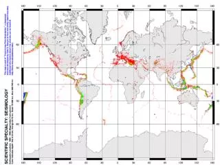
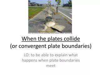
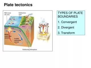
Plate tectonics sites featured include: • Divergent plate boundaries • The Mid-Atlantic Ridge at Iceland • Linear lakes and volcanic activity in the East Africa Rift Valley, the Red Sea) • Convergent plate boundaries • The volcanic islands in the Aleutian Island arc • Volcanoes in the Cascade Mountain Range • Volcanoes in the Andes Mountain Range • The Caribbean volcanic island arc • The Himalaya Mountain Range • Transform plate boundaries • Faulting in the San Andreas Fault Zone in central California
Divergent boundaries are areas in which plates move away from each other. The majority of these divergent boundaries are located along the crests of the mid-oceanic ridges. As the plates separate, fractures occur which are immediately filled with molten rock that up wells from the asthenosphere. This hot material cools and creates a new seafloor. As a result, new oceanic crust (lithosphere) is continuously being created between the diverging plates. The older crust moves away from the boundary, as it does so, it cools and contracts hence increasing in density and in thickness. This is why the older and cooler oceanic crusts are deeper. This average rate of spreading is about 5 cm per year. This is rapid enough to account for the creation of all Earth’s ocean basins within the last 200 million years. None of the ocean floors are older than 180 million years.
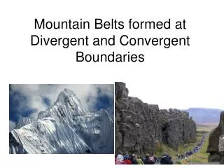
Convergent Boundaries - Continental Continental Mountains
The Himalayas Formed when the Indian Plate Collided with the Eurasian Plate
Convergent Boundaries Subduction Of Oceanic Crust – Forms Trench - Oceanic (denser) Continental
Marianas Trench The older, heavier plate bends and plunges steeply through the asthenosphere, and descending into the earth, it forms a trench that can be as much as 70 miles wide, more than a thousand miles long, and several miles deep. The Marianas Trench, where the enormous Pacific Plate is descending under the leading edge of the Eurasian Plate, is the deepest sea floor in the world. It curves northward from near the island of Guam and its bottom lies close to 36,000 feet below the surface of the Pacific Ocean.
Convergent Boundaries - Oceanic (Older) Oceanic (Younger) Subduction Of Older, Denser Crust
Divergent Boundaries - Oceanic Oceanic Mid-Ocean Ridge Sea-Floor Spreading Creation of New Ocean Floor
Rift Valleys
However, not all divergent boundaries are found in the middle of large oceans. The East African rift valleys represent the initial stage in the breakup of a continent.The volcanic activity associated with divergent boundaries is represented by volcanic mountains such as Kilimanjaro and Mount Kenya. The rift valleys are caused by the associated faulting taking place. As the spreading continues, the rift valley will lengthen and deepen. Eventually, it will spread out into the ocean. This is what transpired at the Red Sea. The Red Sea is the site of a recently formed divergent boundary. Here the Arabian plate separated from the Africa plate a few million years ago and began to move in a northeast direction. Similarly, if the African rift valleys remain active, they will eventually separate from mainland Africa. http://geology.com/plate-tectonics.shtml
Divergent Boundaries - Continental Continental Rift Valley Valley Floor Thins and Sinks Water Could Eventually Fill The Valley
Transform Boundaries New Crust Neither Created nor Destroyed San Andreas Fault Zone California
Converging Continental Crust vs. Continental Crust Converging Mountain Created Oceanic Crust vs. Continental Crust Converging Subduction Oceanic Below Continental Oceanic Crust vs. Oceanic Crust Converging Subduction Oldest Below Youngest
Diverging Continental Crust vs. Continental Crust Diverging Rift Valley Created Oceanic Crust vs. Oceanic Crust Diverging Mid-Ocean Ridge Created