Download
1 / 16
160 likes | 454 Vues
Benefits and Applications of GPS for GIS. Bruce Peetz Vice President Technology Trimble 19 October 2006. Agenda. GPS/GIS Overview – Productivity at the front end of GIS GPS/GIS Applications – Real world examples GPS Augmentation – The sub meter explosion.

E N D
Benefits and Applications of GPS for GIS Bruce Peetz Vice President Technology Trimble 19 October 2006
Agenda • GPS/GIS Overview – Productivity at the front end of GIS • GPS/GIS Applications – Real world examples • GPS Augmentation – The sub meter explosion
How GPS and mobile information systems have enhanced GIS • Ability to define data to be collected prior to field work • Data dictionaries • Ability to quickly and accurately collect information • Location and attribute information • Various levels of positional accuracy • Error checking on attribute entry • Compatibility with GIS and CAD systems
Ways GPS can be used in GIS… • Data collection • Recording something, somewhere • What do I have? • What condition is it in? • Data maintenance • Verifying something, somewhere • Is the information I have correct? • Data use • Current and accurate data to support decision making • Finding the asset to perform maintenance/repair
GPS/GIS Applications in Planning • Urban & Regional Planning • Data collection/maintenance (rural addresses, fire hydrant, signpost inventories) • Cadastral/Land Parcel Delineation • Emergency Planning & Response • Emergency response (wildfire, hurricane) • Pre-event risk assessment • Forestry • Data collection/maintenance • Tree inventory, logging roads, watershed
GPS/GIS Applications in Engineering & Construction • Construction management • Mapping and relocation of assets in lay down yard • Hazardous materials location • Road and highway construction • Inventory of existing infrastructure • Pavement management • Bridge and railroad inspection • Accurate location of inspection • Navigation to location of previous inspection
GPS/GIS Applications in Utilities & Communications • Asset/infrastructure management • Inventory of streetlights, utility poles, storm water facilities • Mapping and relocation of underground assets • Cable, Telephone, Electric • Pipeline integrity management
Real World GPS/GIS Applications • West Nile Virus - Richland County, South Carolina • Mosquito control personnel would pencil in data on cumbersome sheets of paper • Field paperwork would stack up back in the office and get recorded once a month. The data would then have to be re-entered into a database.
Real World GPS/GIS Applications • Enter Mobile GIS • Field crews are now collecting data and transferring it back to the GIS using a custom field application (Mosquito.Mobile) on rugged, sub-meter Geo XT running Windows Mobile • Benefits • Mobile GIS has allowed for improved analysis using location of mosquito breeding sites, location of infected birds combined with mosquito density, rainfall and demographic data • Now when an infected bird is located they are able to notify local child and senior-care centers within hours
Real World GPS/GIS Applications • GIS Road Sign Inventory and Maintenance - Boulder County, Colorado • Mobile GIS/GPS systems running ArcPad • Database on the handheld contains 7,000 signs along with attributes such as sign type and sign condition • Field to Office • Provides consistent flow from Mobile GIS device to database • Data is then sent via network to master database and back to field user Field to Office • Provides consistent flow from Mobile GIS device to database • Data is then sent via network to master database and back to field user
Real World GPS/GIS Applications • Cadastre/Land Administration and Titling • INCRA, Brazil – 300+ Pro XR systems in use for land redistribution • PETT (Proyecto Especial de Tiutulacion de Tierras), Peru – Pro XR systems • IDB-funded project to formalize boundaries and legal title, produce cadastral maps, and record and deliver 525,330 titles in the Coast and Sierra regions to beneficiaries • The end result will be about 178,131 new titles handed over to beneficiaries.
Real World GPS/GIS Applications • Centrales Electricas de Goias • GPS/GIS used to collect data on 1,800,000 poles across 34,000 KM2 • 12 month project involving 160 field technicians and 16 QA personnel • GeoXM and Recon GPS selected to meet 3 meter accuracy requirement • Custom Mobile GIS application: Electropocket by Soltec
GPS Augmentation:Nationwide DGPS • Corrections from NDGPS sites are used in combination with GPS position information to protect U.S. public safety, manage and operate the nation’s utility infrastructure and protect health and the environment
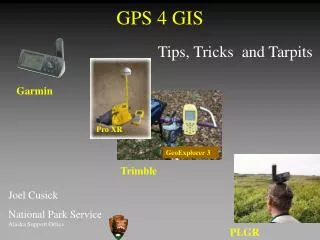
GPS Augmentation: NDGPS impact on public health, safety, and utilities • Public safety • National Park Service employees use corrections from NDGPS sites in forest fire management • Public health • Oakland County, Michigan used corrections from NDGPS site to map the location of wells and septic systems • Utility operations • Emerald County Utilities Authority in Pensacola, Florida used corrections from NDGPS sites to map and relocate critical utility infrastructure following recent hurricanes
GPS Augmentation:Advantages of NDGPS vs. WAAS • NDGPS correction signals curve around the Earth's surface, so users are not limited to "line-of-sight" reception. Natural or man-made obstructions, such as buildings, hills or vegetation, typically don't interfere with signal reception