Download
1 / 1
10 likes | 118 Vues
Hydrologic modeling of conservation farming practices on the Palouse Joshua Van Wie a , Jennifer Adam a , Jeff Ullman b a Department of Civil and Environmental Engineering, b Department of Biological Systems Engineering, Washington State University. Introduction

E N D
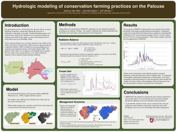
Hydrologic modeling of conservation farming practices on the Palouse Joshua Van Wie a, Jennifer Adam a, Jeff Ullmanb a Department of Civil and Environmental Engineering, b Department of Biological Systems Engineering, Washington State University Introduction The agricultural practice of field tillage has dramatic effects on surface hydrologic properties, significantly altering the processes of infiltration, evaporation, and runoff. In dryland farming regions such as the Palouse of the Pacific Northwest it is essential to maintain an adequate and reliable water supply as water is the limiting factor to crop yield in most years (Pannkuk, 1998). Conservation techniques leave a greater amount of crop residue on the surface after harvest that provides a physical barrier against runoff and evaporation (Fuentes, 2003) in addition to increasing infiltration by regulating soil temperature during cold weather (Singh, 2009). The purpose of this study is to investigate no-till methods and to simulate the over-winter water savings that may occur under widespread adoption of these methods using hydrologic modeling. Methods Tillage effects are represented in DHSVM by adjusting soil and vegetation parameters according to the intensity of tillage. The model is calibrated and verified using field scale runoff data from land under conventional and no-till management. Results The accuracy of DHSVM is determined by error statistics that evaluate the ability of the model to predict historical streamflows. Preliminary model runs for the North Fork Palouse River resulted in a Nash-Sutcliffe coefficient of 0.76 out of maximum possible value of 1.0 and a volume error of 2.3% for a 10-year simulation. These results compare well with previous applications of DHSVM. Further work is necessary to insure that the model is accurately predicting at both the field scale and the watershed scale. It is important to thoroughly understand the implications of field studies on the entire watershed as increased retention of water through the winter months and a higher soil water content at the beginning of the growing season may have the potential to increase crop yields in this arid region. Radiation Balance • Incoming radiation is affected by albedo and transmissivity through the residue layer. A method presented by Novak (2000) is added to DHSVM to adjust transmissivity: • τ (R) = (1 – ΔR) (1 – ΩΔR) • Incoming and outgoing longwave radiation are adjusted by applying a “view factor” to the Stefan-Boltzmann equation representing the fractional vegetation cover: • L = fN+1εsσT4 τ (Ri) = transmittance ΔR = residue area index Ω = clumping index L = longwave radiation fN+1 = view factor ε = emissivity of atmosphere or ground surface σ= Stefan-Boltzmann constant T= temperature of atmosphere or ground surface Frozen Soil • A simple algorithm given by Wigmosta (2009) is added to DHSVM to predict soil freezing using air and surface temperatures and a weighting factor w: • Tts= Tts-1 + w (Tta= Tts-1) • The hydraulic conductivity of frozen soil is reduced so that water does not infiltrate into frozen ground. • Model • The Distributed Hydrology Soil Vegetation Model (DHSVM) (Wigmosta et al., 1994) is applied for this research. • The model is first calibrated and validated at the field scale and then at the watershed scale. • Model inputs include soil, vegetation, and elevation data along with a stream network and climate forcing data. Conclusions • DHSVM has the potential to distinguish some of the key differences between the impacts of no-till farming and conventional methods through the adjusting of soil and vegetation model parameters. • A considerable amount of water may be retained in the seed-zone during the winter months by decreasing evaporation and runoff through the correct use of no-till farming and residue management. • Contact • Joshua Van Wie • Dept. of Civil & Env.Engineering • Pullman, WA 99164-2910 • joshvanwie@hotmail.com Management Scenarios • Region-wide management scenarios are modeled to study the impacts of widespread adoption of conservation methods. Soil moisture is compared for no-till and conventional tillage. B A Soil moisture contents are shown for the North and South forks of the Palouse River basin in early April under two scenarios: Heavy conventional tillage represented by bare soil and low albedo during the winter months. No-till modeled with an understory and high albedo during the winter. Stream network Vegetation Elevation