Download
1 / 71
710 likes | 943 Vues
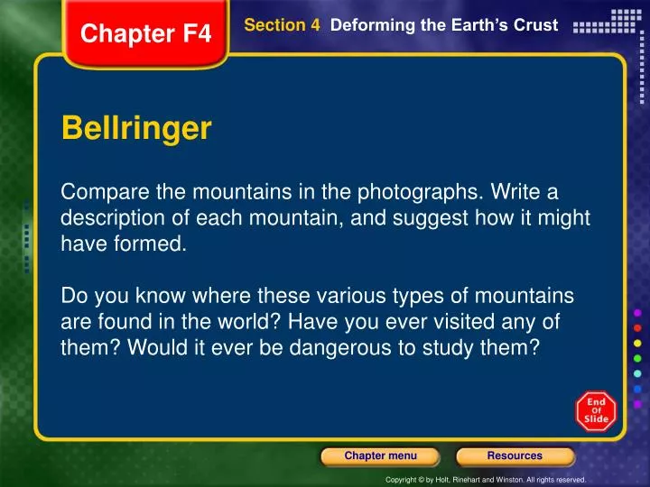
Section 4 Deforming the Earth’s Crust. Chapter F4. Bellringer. Compare the mountains in the photographs. Write a description of each mountain, and suggest how it might have formed.

E N D
Section4 Deforming the Earth’s Crust Chapter F4 Bellringer Compare the mountains in the photographs. Write a description of each mountain, and suggest how it might have formed. Do you know where these various types of mountains are found in the world? Have you ever visited any of them? Would it ever be dangerous to study them?
Section4 Deforming the Earth’s Crust Chapter F4 Objectives • Describe the types of stress that deform rocks and the major types of folds and faults. • Identify the most common types of mountains and explain the difference between uplift and subsidence.
Section4 Deforming the Earth’s Crust Chapter F4 Agenda • Day 1 • Today we will: • Do a do now. • Complete a start up activity. • Learn about mountains. • Day 2 • Today we will:
Section4 Deforming the Earth’s Crust Chapter F4 Objectives • compression • tension • folding • syncline • anticline • fault • uplift • subsidence
Section4 Deforming the Earth’s Crust Chapter F4 Deformation • Whether a material bends or breaks depends on the how much stress is applied to the material. • Stress is the amount of force per unit area on a given material. • Different things happen to rock when different types of stress are applied.
Section4 Deforming the Earth’s Crust Chapter F4 Deformation, continued • The process by which the shape of a rock changes because of stress is called deformation. • Rock layers bend when stress is placed on them. • When enough stress is placed on rocks, they can reach their elastic limit and break.
Section4 Deforming the Earth’s Crust Chapter F4 Deformation, continued • The type of stress that occurs when an object is squeezed, such as when two tectonic plates collide, is called compression. • When compression occurs at a convergent boundary, large mountain ranges can form.
Section4 Deforming the Earth’s Crust Chapter F4 Deformation, continued • Tension is stress that occurs when forces act to stretch an object. • Tension occurs at divergent plate boundaries, such as mid-ocean ridges, when two tectonic plates pull away from each other.
Section4 Deforming the Earth’s Crust Chapter F4 Folding • The bending of rock layers because of stress in the Earth’s crust is called folding. • Types of Folds Depending on how rock layers deform, different types of folds are made. • The major types of folds are anticlines, synclines, and monoclines.
Section4 Deforming the Earth’s Crust Chapter F4 Folding, continued • Anticlines are upward-arching folds. • Synclines are downward, troughlike folds.
Section4 Deforming the Earth’s Crust Chapter F4 Folding, continued • In amonocline,rock layers are folded so that both ends of the fold are horizontal.
Section4 Deforming the Earth’s Crust Chapter F4 Faulting • Some rock layers break when stress is applied. The surface along which rocks break and slide past each other is called a fault. • The blocks of crust on each side of the fault are calledfault blocks.
Section4 Deforming the Earth’s Crust Chapter F4 Faulting, continued • When a fault is not vertical, its two sides are either a hanging wall or a footwall.
Section4 Deforming the Earth’s Crust Chapter F4 Faulting, continued • The type of fault depends on how the hanging wall and footwall move in relationship to each other. • When a normal fault moves, it causes the hanging wall to move down relative to the footwall.
Section4 Deforming the Earth’s Crust Chapter F4 Faulting, continued • When a reverse fault moves, it causes the hanging wall to move up relative to the footwall.
Section4 Deforming the Earth’s Crust Chapter F4 Faulting, continued • A third major type of fault is a strike-slip fault. These faults form when opposing forces cause rock to break and move horizontally.
Section4 Deforming the Earth’s Crust Chapter F4 Plate Tectonics and Mountain Building • When tectonic plates collide, land features that start as folds and faults can eventually become large mountain ranges. • When tectonic plates undergo compressions or tension, they can form mountains in several ways.
Section4 Deforming the Earth’s Crust Chapter F4 Mountain Building, continued • Folded Mountains form when rock layers are squeezed together and pushed upward. • Fault-Block Mountains form when large blocks of the Earth’s crust drop down relative to other blocks. • Volcanic Mountains form when magma rises to the Earth’s surface and erupts.
Section4 Deforming the Earth’s Crust Chapter F4 Uplift and Subsidence • Vertical movements in the crust are divided into two types—uplift and subsidence. • Uplift is the rising of regions of the Earth’s crust to higher elevations. • Subsidence is the sinking of regions of the Earth’s crust to lower elevations.
Section4 Deforming the Earth’s Crust Chapter F4 Uplift and Subsidence, continued • Uplifting of Depressed Rocks Uplift can occur when large areas of land rise without deforming. • One way areas rise without deforming is process known as rebound. When the crust rebounds, it slowly springs back to its previous elevation.
Section4 Deforming the Earth’s Crust Chapter F4 Uplift and Subsidence, continued • Subsidence of Cooler Rocks Rocks that are hot take up more space than cooler rocks. • The lithosphere is relatively hot at mid-ocean ridges, but cools as it moves farther from the ridge. • As it cools, the oceanic lithosphere takes up less volume and the ocean floor subsides.
Section4 Deforming the Earth’s Crust Chapter F4 Uplift and Subsidence, continued • Tectonic Letdown Subsidence can also occur when the lithosphere becomes stretched in rift zones. • A rift zone is a set of deep cracks that forms between two tectonic plates that are pulling away from each other. • As tectonic plates pull apart, stress between the plates causes a series of faults to form along the rift zone.
Exit Ticket • What are mountains? Explain at least 2 ways in which they form.
Plate Tectonics Chapter F4 Concept Map Use the terms below to complete the concept map on the next slide.
Plate Tectonics Chapter F4
Plate Tectonics Chapter F4
Chapter F4 End of Chapter F4 Show
Standardized Test Preparation Chapter F4 Reading Read each of the passages. Then, answer the questions that follow each passage.
Standardized Test Preparation Chapter F4 Passage 1The Deep Sea Drilling Project was a program to retrieve and research rocks below the ocean to test the hypothesis of sea-floor spreading. For 15 years, scientists studying sea-floor spreading conducted research aboard the ship Glomar Challenger.Holes were drilled in the sea floor from the ship. Continued on the next slide
Standardized Test Preparation Chapter F4 Passage 1, continuedLong, cylindrical lengths of rock, called cores, were obtained from the drill holes. By examining fossils in the cores, scientists discovered that rock closest to mid-ocean ridges was the youngest. The farther from the ridge the holes were drilled, the older the rock in the cores was. This evidence supported the idea that sea-floor spreading creates new lithosphere at mid-ocean ridges.
Standardized Test Preparation Chapter F4 1. In the passage, what does conducted mean? Adirected Bled Ccarried on Dguided
Standardized Test Preparation Chapter F4 1. In the passage, what does conducted mean? Adirected Bled Ccarried on Dguided
Standardized Test Preparation Chapter F4 2. Why were cores drilled in the sea floor from the Glomar Challenger? Fto determine the depth of the crust Gto find minerals in the sea-floor rock Hto examine fossils in the sea-floor rock Ito find oil and gas in the sea-floor rock
Standardized Test Preparation Chapter F4 2. Why were cores drilled in the sea floor from the Glomar Challenger? Fto determine the depth of the crust Gto find minerals in the sea-floor rock Hto examine fossils in the sea-floor rock Ito find oil and gas in the sea-floor rock
Standardized Test Preparation Chapter F4 3. Which of the following statements is a fact according to the passage? ARock closest to mid-ocean ridges is older than rock at a distance from mid-ocean ridges. BOne purpose of scientific research on the Glomar Challenger was to gather evidence for sea-floor spreading. CFossils examined by scientists came directly from the sea floor. DEvidence gathered by scientists did not support sea-floor spreading.
Standardized Test Preparation Chapter F4 3. Which of the following statements is a fact according to the passage? ARock closest to mid-ocean ridges is older than rock at a distance from mid-ocean ridges. BOne purpose of scientific research on the Glomar Challenger was to gather evidence for sea-floor spreading. CFossils examined by scientists came directly from the sea floor. DEvidence gathered by scientists did not support sea-floor spreading.
Standardized Test Preparation Chapter F4 Passage 2The Himalayas are a range of mountains that is 2,400 km long and that arcs across Pakistan, India, Tibet, Nepal, Sikkim, and Bhutan. The Himalayas are the highest mountains on Earth. Nine mountains, including Mount Everest, the highest mountain on Earth, are more than 8,000 m tall. Continued on the next slide
Standardized Test Preparation Chapter F4 Passage 2, continuedThe formation of the Himalaya Mountains began about 80 million years ago. A tectonic plate carrying the Indian subcontinent collided with the Eurasian plate. The Indian plate was driven beneath the Eurasian plate. This collision caused the uplift of the Eurasian plate and the formation of the Himalayas. This process is continuing today.
Standardized Test Preparation Chapter F4 1. In the passage, what does the word arcs mean? Aforms a circle Bforms a plane Cforms a curve Dforms a straight line
Standardized Test Preparation Chapter F4 1. In the passage, what does the word arcs mean? Aforms a circle Bforms a plane Cforms a curve Dforms a straight line
Standardized Test Preparation Chapter F4 2. According to the passage, which geologic process formed the Himalaya Mountains? Fdivergence Gsubsidence Hstrike-slip faulting Iconvergence
Standardized Test Preparation Chapter F4 2. According to the passage, which geologic process formed the Himalaya Mountains? Fdivergence Gsubsidence Hstrike-slip faulting Iconvergence
Standardized Test Preparation Chapter F4 3. Which of the following statements is a fact according to the passage? AThe nine tallest mountains on Earth are located in the Himalaya Mountains. BThe Himalaya Mountains are located within six countries. CThe Himalaya Mountains are the longest mountain range on Earth. DThe Himalaya Mountains formed more than 80 million years ago.
Standardized Test Preparation Chapter F4 3. Which of the following statements is a fact according to the passage? AThe nine tallest mountains on Earth are located in the Himalaya Mountains. BThe Himalaya Mountains are located within six countries. CThe Himalaya Mountains are the longest mountain range on Earth. DThe Himalaya Mountains formed more than 80 million years ago.
Standardized Test Preparation Chapter F4 Interpreting Graphics This illustration shows the relative velocities (in centimeters per year) and directions in which tectonic plates are separating and colliding. Arrows that point away from one another indicate plate separation. Arrows that point toward one another indicate plate collision.
Standardized Test Preparation Chapter F4 1. Between which two tectonic plates does spreading appear to be the fastest? Athe Australian and the Pacific Bthe Antarctic and the Pacific Cthe Nazca and the Pacific Dthe Cocos and the Pacific
Standardized Test Preparation Chapter F4 1. Between which two tectonic plates does spreading appear to be the fastest? Athe Australian and the Pacific Bthe Antarctic and the Pacific Cthe Nazca and the Pacific Dthe Cocos and the Pacific
Standardized Test Preparation Chapter F4 2. Where do you think mountain building is taking place? Fbetween the African and South American plates Gbetween the Nazca and South American plates H between the North American and Eurasian plates Ibetween the African and North American plates
Standardized Test Preparation Chapter F4 2. Where do you think mountain building is taking place? Fbetween the African and South American plates Gbetween the Nazca and South American plates H between the North American and Eurasian plates Ibetween the African and North American plates