Download
1 / 39
390 likes | 399 Vues
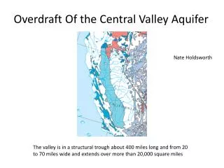
Appraisal of the Northern Shenandoah Valley Non-Carbonate Aquifer System, Warren County, Virginia. January 25, 2011. Generalized geologic province map of Warren County, Virginia. Location of study area. Nelms and Moberg (2010) Figure 1, p. 3. Average monthly precipitation.

E N D
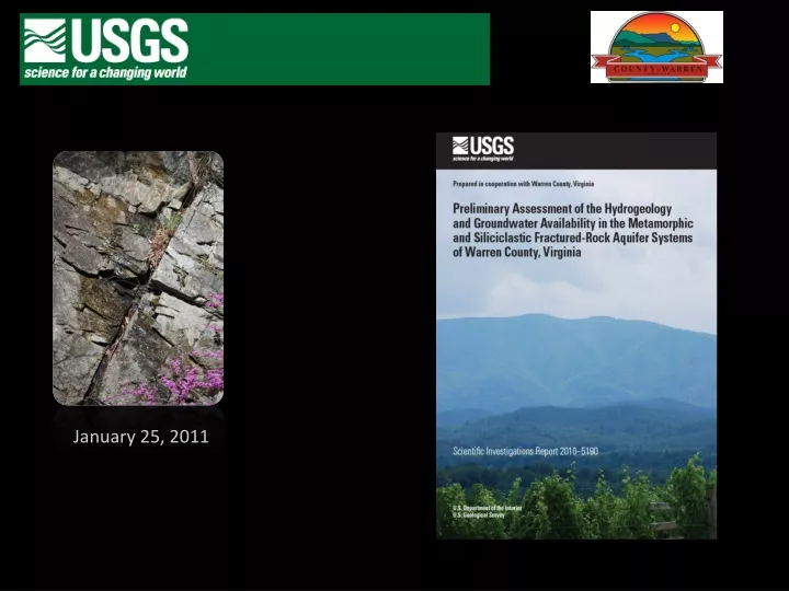
Appraisal of the Northern Shenandoah Valley Non-Carbonate Aquifer System, Warren County, Virginia January 25, 2011
Generalized geologic province map of Warren County, Virginia Location of study area Nelms and Moberg (2010) Figure 1, p. 3
Average monthly precipitation Nelms and Moberg (2010) Figure 3, p. 5
Average annual precipitation across Warren County, Virginia, based on parameter-elevation regressions on independent slopes model (PRISM). Normal values are based on the National Weather Service’s current normal climatological period from 1971 to 2000. Data from PRISM Climate Group, Oregon State University, http://www.prismclimate.org, created 12 May 2009 Nelms and Moberg (2010) Figure 4, p. 6
Generalized hydrogeologic units of Warren County, Virginia Geology from Rader and Conley (1995), Rader and Gathright (2001), Rader and others (2001, 2003), Virginia Division of Mineral Resources (2003), and Southworth and others (2009). Nelms and Moberg (2010) Figure 5, p. 8
Generalized hydrogeologic section across Warren County, Virginia Modified from Rader and Conley (1995) Nelms and Moberg (2010) Figure 2, p. 4
Joint types and bedding in folded rocks Modified from Earth Science Australia (2004); Harlow and others (2005).
Generalized conceptual hydrogeologic longitudinal section of the flow system in the Blue Ridge Physiographic Province in Warren County, Virginia Nelms and Moberg (2010) Figure 26, p. 41
Generalized conceptual hydrogeologic sections along strike and cross-strike in the siliciclastic fractured-rock flow system (Martinsburg Formation) in Warren County, Virginia. Nelms and Moberg (2010) Figure 27, p. 42
Summary statistics of well-construction and hydrologic characteristics of the rock units in Warren County, Virginia Nelms and Moberg (2010) Figure 8, p. 16
Summary statistics of well-construction and hydrologic characteristics of the rock units in Warren County, Virginia
Summary statistics of well-construction and hydrologic characteristics of the rock units in Warren County, Virginia
Depth to bedrock in Warren County, Virginia From Well-completion reports Nelms and Moberg (2010) Figure 9, p. 17
Depth to top of upper reported water-bearing zones in Warren County, Virginia From Well-completion reports Nelms and Moberg (2010) Figure 10, p. 19
Depth to top of lower reported water-bearing zones in Warren County, Virginia From Well-completion reports Nelms and Moberg (2010) Figure 11, p. 20
Reported well yields in Warren County, Virginia Nelms and Moberg (2010) Figure 12, p. 21
Density of wells with reported well yields less than 5 gallons per minute in Warren County, Virginia Nelms and Moberg (2010) Figure 13, p. 23
Density of wells with reported well yields greater than 50 gallons per minute in Warren County, Virginia Nelms and Moberg (2010) Figure 14, p. 24
Location of streamflow gaging stations, springs, and wells in the long-term water monitoring network for Warren County, Virginia. Nelms and Moberg (2010) Figure 15, p. 27
Water Levels Warren County Siliciclastic Rock 45V 3 Blue Ridge Shadows 45V 4 Blue Ridge Shadows (Destroyed) Clarke County Carbonate Rock 46W175 Blandy Farm National Weather Service Climatological Station 443229 Front Royal, Virginia Nelms and Moberg (2010) Figure 16, p. 28
Relation between water levels in well 45V 3, and combined effects of barometric pressure and earth tides, and of teleseismic earthquakes. Magnitude 8.4 - Southern Sumatra, Indonesia 2007 September 12 11:10:26 UTC Nelms and Moberg (2010) Figure 19, p. 31
Streamflow in Warren County, VA Warren County Streamflow Gages USGS 01630700 USGS 01630700 Gooney Run at Route 622 near Glen Echo, VA USGS 01636242 Crooked Run below Route 340 at Riverton, VA USGS 01636242 USGS 0163626650 Manassas Run at Route 645 near Front Royal, VA USGS 0163626650 Nelms and Moberg (2010) Figure 20, p. 32
Quarterly Spring Discharge in Warren County, VA 45VS 1 45VS 1 Weddle Spring (Carbonate) 46VS 17 46VS 17 High Knob Spring (Metamorphic) Nelms and Moberg (2010) Figure 21, p. 33
Warren County Metamorphic Basins 01630700 Gooney Run at Route 622 near Glen Echo, Va. 0163626650 Manassas Run at Route 645 near Front Royal, Va. Warren County Siliciclastic Basin 01636242 Crooked Run below Route 340 at Riverton, Va. Riparian Evapotranspiration Nelms and Moberg (2010) Figure 22, p. 35
Apparent age and percentage of young water fraction for sampling sites in Warren County, Virginia Apparent age data for Shenandoah National Park sites from Plummer and others (2000) Virginia Aquifer Susceptibility site from Nelms and others (2003). Nelms and Moberg (2010) Figure 24, p. 37
Apparent groundwater ages and percentage of young fraction in water samples from wells and springs in Warren County, Virginia, 2003–2005. Nelms and Moberg (2010) Table 3, p. 39
Apparent groundwater ages and percentage of young fraction in water samples from wells and springs in Warren County, Virginia, 2003–2005. Nelms and Moberg (2010) Table 3, p. 39
Hydrograph Separation—Streamflow Partitioning (PART) Where the curves coincide, groundwater discharge equals streamflow.
Annual water budget components for the Gooney Run, Crooked Run, and Manassas Run Basins in Warren County, Virginia, 2001–2007
Annual water budget components for the Gooney Run, Crooked Run, and Manassas Run Basins in Warren County, Virginia, 2001–2007
Annual water budget components for the Gooney Run, Crooked Run, and Manassas Run Basins in Warren County, Virginia, 2001–2007
Relation between annual rates of precipitation, mean streamflow, and mean base flow National Weather Service climatological station 443229 Front Royal, Virginia Nelms and Moberg (2010) Figure 31, p. 55
Relation between annual precipitation and effective recharge Warren County, Virginia Warren County Metamorphic Basins 01630700 Gooney Run at Route 622 near Glen Echo, VA 0163626650 Manassas Run at Route 645 near Front Royal, VA Warren County Siliciclastic Basin 01636242 Crooked Run below Route 340 at Riverton, VA Nelms and Moberg (2010) Figure 28, p. 47
Drainage basins and parcel acreage in Warren County, Virginia Nelms and Moberg (2010) Figure 29, p. 51
Physical and geologic characteristics, estimated effective recharge rates, and estimated water use at buildout of ungaged basins in Warren County, Virginia Nelms and Moberg (2010) Table 7, p. 52-53
Physical and geologic characteristics, estimated effective recharge rates, and estimated water use at buildout of ungaged basins in Warren County, Virginia
Physical and geologic characteristics, estimated effective recharge rates, and estimated water use at buildout of ungaged basins in Warren County, Virginia Nelms and Moberg (2010) Table 7, p. 52-53
Estimated domestic water usage at buildout and varying percentages of annual effective recharge for ungaged basins in Warren County, Virginia. • Estimated from the linear regression method of Yager and others (2008) • Domestic usage based on 2.48 individuals per parcel multiplied by 75 gallons per day per person normalized over the drainage basin area. • Current planning uses 50% of average annual effective recharge Yager and others, 2008 Nelms and Moberg (2010) Figure 30, p. 54
Publication Availability http://va.water.usgs.gov/warren/pub.htm http://pubs.usgs.gov/sir/2010/5190/