Download
1 / 70
710 likes | 826 Vues
Geology in the News. From the New York Times, Feb. 3, 2012. Mount Isa , Queensland, Australia World’s Largest Cu, Pb, Sn Mining Operation. Mount Isa. Mount Isa. Mount Isa , Queensland, Australia World’s Largest Cu, Pb, Sn Mining Operation. Mining Operation.

E N D
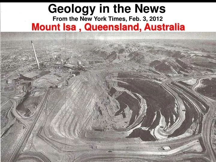
Geology in the News From the New York Times, Feb. 3, 2012 Mount Isa , Queensland, Australia World’s Largest Cu, Pb, Sn Mining Operation
Mount Isa , Queensland, Australia World’s Largest Cu, Pb, Sn Mining Operation Mining Operation Toxic waste area
Open Pit Mine Copper. Lead, silver miners in Pre-Cambrian shale and volcanic rock, 2 billion years old
Vagabond Venture Oil Group SEARCH FOR FOSSIL FUELS Winter 2012
The Course Outline The Basics: Week 1: Geology of Coal, Oil and Gas Week 2: Processes of Exploration Week 3: Engineering Processes: Reservoir/ Drilling/Production The Adventure: Week 4: ‘Vagabond Group’ chooses 2 prospects Week 5: ‘Vagabond Group’ drills Week 6: the Payout?! Your chance to invest ! A black-gold millionaire or dry hole hobo?
By now, you should start to see that deciding • WHAT to drill • WHERE to drill & • HOW to drill • is a TEAM EFFORT • Composed of • GEOLOGIST, GEOPHYSICIST, • LANDMEN, & ENGINEERS Today . . . .
Petroleum Engineer Primary Jobs: Reservoir Characterization Economic Analysis Covered in CLASS No. 6 Well Design & Drilling Production & Enhancements Covered in CLASS No. 5
Petroleum Engineer: Reservoir Characterization Job #1 Reservoir Characterization
Petroleum Engineer: Reservoir Characterization • “Reservoir characterization methodology: • determining reservoir architecture, • establishing fluid-flow trends, • constructing reservoir model, and • identifying reserve growth potential • Further investigations within reservoir type: • integrating data: petrophysical, seismic, and geologic attributes • 3-D geo-celluarmodel building; • delineating flow units and fluid flow compartments, • documenting reserve growth concepts under varying reservoir conditions” • Texas Bureau of Economic Geology
Petroleum Engineer: Reservoir Characterization From Seismic Data
Petroleum Engineer: Reservoir Characterization Generalized Stratigraphic Map
Petroleum Engineer: Reservoir Characterization PETROPHYSICAL & PALEO DATA Laboratory Analysis Well core Lithology Paleo Analysis
Petroleum Engineer: Reservoir Characterization PETROPHYSICAL DATA Laboratory Analysis Porosity – a measure of the open spaces within a rock that can contain oil or water. Unit of measurement is PERCENT Permeability – a measure of the ability for fluid to flow thru a rock. Unit of measurement is DARCY Point of Reference: Concrete BlockBrick Gulf of Mexico Pliocene Sandstone 1 millimeter Porosity Permeability +/- 20% +/- 5 % 2 – 5 D .025 D (25 mD)
Petroleum Engineer: Reservoir Characterization PETROPHYSICAL DATA – Rules of Thumb
Petroleum Engineer: Reservoir Characterization Correlation of Well Logs (more on logging later…)
Petroleum Engineer: Reservoir Characterization Resulting in Reservoir Model • Reservoir characteristics are input to a program that generates a 3D map of the subsurface reservoir • The 3D map can then be used to assess where hydrocarbon has migrated to which then indicates where future wells should be drilled
Petroleum Engineer: Reservoir Characterization TYPICAL QUESTIONS TO ASK REGARDING RESERVOIR CHARACTERIZATION • What is the source rock? • What type of reservoir rock is expected? • What reservoir porosity is expected? • What reservoir permeability is expected? • What is the expected trapping mechanism? • What type of drive mechanism is expected? • Is the well type a straight hole or deviated? • What is the planned TD (total depth) of the well? • How many feet of pay is expected? • How do characteristics vary between in-field wells? • How many PROVEN reserves are expected to be found? SPEAKING OF “RESERVES”…
Petroleum Engineer: Reservoir Characterization Classification of Reserves is key! What are Reserves? The amount of oil & gas in a reservoir currently available for production Why are they important?: Reserves when produced generate a cash flow and by estimating the total cash flow from a well, the “expected value” of that well can be calculated. This sets the limit on much you can spend in developing the well for any expected Return on Investment (ROI)!
Petroleum Engineer: Reservoir Characterization Classification of Reserves is key! • BUT… • There are several different reserves names used: • Reserves in Place (physically contained in the reservoir; remember that only 25 to 30% of that can actually be recovered with conventional technologies; OOIP) • Recoverable Reserves (estimate of what can be produced from the reservoir) • Proven Reserves, Developed or Undeveloped (reserves that can be calculated with reasonable certainty because the field has been defined by appraisal well(s) that have been tested) • Proved Behind-Pipe Reserves (undeveloped, proven reserves calculated behind the casing) • Proved (P90), Probable (P50) and Possible (P10) Reserves
Petroleum Engineer: Reservoir Characterization Classification of Reserves is key! • Proved (P90) Reserves – 90 % chance or greater that the reserves are there; must have “very high certainty” that reserves can be “economically” recovered with current technology. Security and Exchange Commission (SEC) allows only reporting of P90 as official data. • Probable (P50) Reserves- 50 % chance that the reserves are there • Possible (P10) Reserves - 10 % chance that the reserves are there • Remember estimates are based on data from a location as much as 2 miles below the surface, and on characteristics of a hole 6” in diameter extrapolated over several hundred acres of reservoir… • Reserves estimating is more of an art than a science!
Petroleum Engineer: Reservoir Characterization Note that the world understands that “proved” reserves is what’s important… USA Today
Petroleum Engineer: Reservoir Characterization Note that the world understands that “proved” reserves is what’s important… 10th ! Domestic International
Petroleum Engineer: Reservoir Characterization Note that the world understands that “proved” reserves is what’s important… 6th !
Petroleum Engineer: Well Design & Drilling Job #2 Well Design and Drilling
Petroleum Engineer: Well Design Well Design during drilling Blowout Preventer Blowout Preventer – Monitor & Controls the pressure within each casing string of the well Casing String – Successive sections of pipe of decreasing diameter set one inside the other and cemented in place Surface `` Casing Strings
Petroleum Engineer: Well Design How is Casing Installed? • Drill 36” hole to design depth • Slide 30” casing to depth within 36” hole • Cement 30” casing to 36” hole • Drill 24” hole thru cement in 30” casing to design depth • Slide 20” casing to depth within the 24” hole • Cement 20” casing to 24” hole • And so on …. Surface 30” Casing 36”hole 24”hole 20” Casing
Petroleum Engineer: Well Design Typical Well Casing Program • 30” Casing = Conductor Pipe (hung at surface; it is drilled or driven) • 20” Casing = Surface Casing (hung at surface; may not be necessary, depends on geology) • 13 3/8” Casing = Intermediate Casing (hung at the surface) • 9 5/8” Casing = Intermediate casing (depending on design, could be hung off of 13 3/8”) • 7” Liner = Not a casing per se because it is hung off the end of the 9 5/8” casing; it doesn’t run to the surface Casing Size Depth 30 in (36”hole) 500 ft 20 in (26”hole) 3,000 ft 13 3/8 in (17 ½” hole) 7,000 ft 9 5/8 in (12 ½” hole) 10,000 ft 7 in Liner (8½” hole) 15,000 ft
Petroleum Engineer: Well Design Well Casing Program • Why is casing needed? • Protect freshwater aquifers that might be present in the subsoil • Prevents contamination between rock strata layers • Contain any unusual pressure in the layers of rock strata that might be encountered • Prevent borehole collapse while drilling deeper • Provide control of drilling mud being pumped down-hole Freshwater Aquifer Low Pressure Zone or future producing zone Wellbore thru the rock strata High Pressure Zone Black Gold! Cap Rock http://www.youtube.com/watch?NR=1&v=fNq2uKfSvhw&feature=endscreen
Petroleum Engineer: Well Design Well Design during completion Xmas Tree Xmas Tree– Monitor & Controls the pressure within the each casing of the well while allowing the well to flow to the surface Perforations– Holes shot thru the casing to allow fluid to flow into the wellbore Down-hole Completion Equipment – Devices & tools installed in the well to control which reservoir is produced and to give real-time data Surface `` Down-hole Completion Equipment` Perforations
Captured from a YouTube Video. This is a section of pipe tubing; Shaped charges will be set off to make the perforations. These pictures show the power of the shaped charges…
Petroleum Engineer: Well Design Well Design during completion To Production Facilities Xmas Tree Production Tubing – A string of pipe that runs from the producing zone to the wellhead in which oil and/or gas flows to the surface facilities Surface `` Down-hole Completion Equipment` Perforations
Petroleum Engineer: Well Design Types of Well Design • “Straight-hole” • Directional or “Deviated Well” • “Horizontal Well” Black Gold! Cap Rock
Petroleum Engineer: Well Design Deviated Well • Why drill a deviated well? • Known fault can cause an unplanned deviation from the projected drill path • High pressure zones might exist to one side of a fault • Subsurface “debris” like ancient reefs could cause a slower drill rate (ROP) than desired (time is money!) High Pressure zones behind fault Fault Black Gold! Cap Rock
Petroleum Engineer: Well Design Deviated, Horizontal Wells • Why drill a horizontal well? • Low permeability reservoirs are best produced by horizontal wells, the ultimate in “deviated well” • Three kinds of horizontal wells, long/short/medium radius: • Long = 10 per 100ft • Medium = 20 per 100ft • Short = 40 per 100ft Target Reservoir
Petroleum Engineer: Well Design Horizontal Well Procedure • At start of deviation, replace drillbit with a “bent sub”, gyroscope, steerable mud motor & bit • Add logging-while-drilling (LWD) unit & power pack within 20 ft of bit • Slowly rotate drillstring to prevent “sticking” & start “pushing” steerable system forward while flowing mud to mud motor • Drill while being pushed forward & steer system as need be to maintain horizontal direction
Petroleum Engineer: Well Design Multilateral, Horizontal Wells • Added advantage of horizontal well design is to include “Multilaterals” (additional boreholes from the same drillsite) • From one wellsite, several sections of the reservoir can be accessed & produced Significant Production Increase Drillsite Plan view
Petroleum Engineer: Drilling Plan Horizontal Drilling Advantages • Increase in reserves in place by 2% of the original oil in place (OIIP)** • Cost ratio of horizontal versus vertical wells is approximately 2 to 1** • Production ratio for horizontal wells versus vertical wells is approximately 3.2 to 1** • Inclusion of multilaterals increases production ratio even more!! ** per U.S. Department of Energy
Petroleum Engineer: Well Design Final Well Program • Well Schematic – Showing hole (bit) size, casing plan, mud plan, planned TD • Drilling Time Estimate – Breakdown total time into key components to various depths • Well Cost Estimate – Listing of all expected costs for the well • Well Time VS. Depth Plot – a “picture” of how much drilling time is planned for each casing run
Petroleum Engineer: Drilling LETS GET STARTED DRILLING!!
Petroleum Engineer: Drilling Well Location? Onshore Offshore
Petroleum Engineer: Drilling Well Type? Exploratory (“Wildcat Well”) On-structure (“In-field”, Appraisal) Normal Success Rate = +/-1 in 10 to +/- 3 in 10 Normal Success Rate = +/- 5 in 10 to +/-9 in 10
Petroleum Engineer: Drilling Main Components of Drilling Derrick Traveling Block/Swivel Turntable/Kelly/ Kelly Bushing Blowout Preventer Casing (different sizes) Drill String Drill Bit Drill Mud
Petroleum Engineer: Drilling Drilling Mud Mud IN • What is Drilling Mud • A mixture of clay with either water, oil, oil and water, or synthetic organic matter and water. To this, various viscosity and density enhancers and additives to achieve specific objectives (adjust pH, control bacteria, de-foam, filtrate reducers, etc.) are added. Mud out Well bore How does it get in the well? Mud is pumped into the drill pipe, flows down the drill pipe, exits out the drill bit, and flows, along with rock cuttings, up the borehole back to the rig. Drill Bit
Petroleum Engineer: Drilling What is the Drilling Mud System? • A ‘CLOSED SYSTEM’ where the drilling mud is mixed & pumped: • from the mud pit/tanks, • up into the mud hose • down into the drillstring, • thru the drillbit, • up the wellbore, • over the shellshakers and • back to the mud pit/tanks 3. Mud Hose 2. Mud Pump 1. Mud Pit or Tanks 4. Circulate Mud down drillstring and back up borehole exit below Blowout Preventer 5. Shale shakers
Petroleum Engineer: Drilling What does Drilling Mud do? • Cools drill-bit • Stabilizes borehole walls • Transports rock cuttings (“cuttings”) to surface (mud engineer examines cuttings w/microscope to check for oil and porosity) • Offsets hydrostatic/reservoir pressure


![READ [PDF] New York Times Wednesday Crossword Puzzle Omnibus Volume 3 (New York Times](https://cdn7.slideserve.com/12661648/slide1-dt.jpg)