Download
1 / 28
280 likes | 352 Vues
Explore Capilano, Fulton Place, and Gold Bar with endless recreation activities year-round. Discover scenic routes, mature trees, ravines, and historical sites while staying active!

E N D
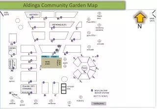
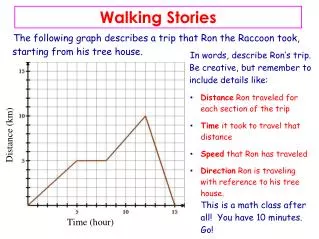
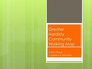
Greater Hardisty Community Walking Map Fulton Place Capilano & Gold Bar
Greater Hardisty Community Walking Map The communities of Capilano, Fulton Place and Gold Bar, often referred to as Greater Hardisty, invite active living. The district is bordered by the North Saskatchewan River to the north, Fulton Ravine to the west and Gold Bar Ravine to the east.
Recreation activities are endless. In winter, go skating at one of the outdoor rinks within the three community leagues. There is also the Michael Cameron Arena, the Ottewell Curling Club, 10 km of lighted cross-country ski trails, and toboggan hills that range from bunny runs to kamikaze.
Summer Summer amenities include sports fields, ball diamonds, playgrounds, spray parks and the Capilano Tennis Club. One can stroll through quiet neighbourhoods enjoying the well-landscaped yards and mature trees, or hike and bike the many ravine and river valley trails. Picnic spots are numerous. At any time of year, enjoy the Hardisty Leisure and Fitness Centre, the off-leash dog parks, and the six suggested walking routes on this map.
Signature View Picnic tables and benches invite people to stay awhile and enjoy the view of the river and the Edmonton skyline.
4.8 Km Loop • 4.8 km • Connects all three community leagues • A mini-loop around one community league block is about 1 km • The walk includes other green spaces, well-landscaped yards and mature trees • Start at any community league to make the loop
6 Km Figure-Eight Loop • The two routes meet at Sobey’s shopping centre • North: 2.6 km South: 3.4 km • Two original farm houses on 101 A Ave • The districts were originally surveyed as river lots • St. Michael’s Catholic Church was designed by Douglas Cardinal • Grotski/Cardinal House –Designated Historic Site • Net Zero House • MacLab Development 1957 • Mature spruce were once Grade 1 seedlings • Coal Mines & Gold Panning are part of the community history • Mature trees
American Elm Mature trees grace the neighborhood
Scenic Workout 3.5 km • 3.5 km • Start near Hardisty Swimming Pool • Scenic Lookout along Hardisty Drive • Follows the Trans Canada Trail • Can link to other trails on the walking map and to the river valley trail system to extend your workout
Stair Workout 3.0 km • 3.0 km • Park near Hardisty Pool • Cross Fulton Ravine Bridge & 54 stairs • Cross Gretzky Drive on Pedestrian Bridge • 179 Stairs – river view downstream east • Two landings on the stairs are great for workouts • Bottom of stairs link to river valley trails East, West and North
Scenic East 2.5 km • 2.5 km • Start at the Ottewell Curling Rink • Follow the lane along the top of Gold Bar Ravine • Views of Gold Bar Ravine, the refineries, the river, Ada Blvd. and Rundle Park
Fulton Ravine 1.5 km • 1.5 km • Fulton Toboggan Hill • Terrace Heights Playground • Charming bridge over Fulton Creek • 54 steps out of the ravine on south side • Uneven trail surface • Hiking path along the creek is very rough • Three storm control bridges over the creek • Marsh marigolds in the spring • Home to rabbits & coyotes
Gold Bar Ravine 3.0 km • 3 km – starting at Gold Bar Community League • 2.5 km – parking pullout on 106B Avenue • Ties in with river valley trails • Shelter with washrooms in Gold Bar Park • Rugged pathway • Links to river valley trails including Goldstick Park X-C ski trails • Commemorative marker to Premier Lougheed and those who started river valley system