Download
1 / 31
310 likes | 456 Vues
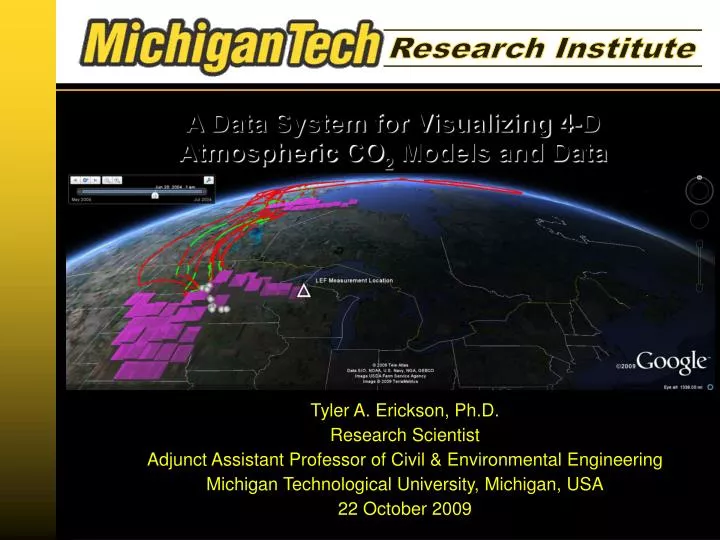
A Data System for Visualizing 4-D Atmospheric CO 2 Models and Data. Tyler A. Erickson, Ph.D. Research Scientist Adjunct Assistant Professor of Civil & Environmental Engineering Michigan Technological University, Michigan, USA 22 October 2009. Collaborators.

E N D
A Data System for Visualizing 4-D Atmospheric CO2 Models and Data Tyler A. Erickson, Ph.D. Research Scientist Adjunct Assistant Professor of Civil & Environmental Engineering Michigan Technological University, Michigan, USA 22 October 2009
Collaborators Prof. Anna M. MichalakUniversity of MichiganAnn Arbor, Michigan, USA Carbon Cycle Science Researcher Prof. John C. LinUniversity of WaterlooWaterloo, Ontario, Canada STILT Atmospheric Transport Model Creator
Time is Important Geospatial representation of present conditions is fine,but predicting future conditions is really useful and interesting...
Temporal Change is Everywhere Land cover change Climate Change Disease Spread Environmental Change Economic Change Photo credit: John McColgan of the Bureau of Land Management, Alaska Fire Service
Spatial-Temporal Data radio collar(a.k.a. caribou bling) Location: North Slope of Alaska, USASource: The National Academies Location: Central CanadaSource: NASA
Problem #1: Too Few Data! Collecting data with in-situ sensors is expensive Even with dense meshesof sensors, processes are severely undersampled Soddie Meteorological TowerLocation: Niwot Ridge LTER, Colorado, USASource: Tyler Erickson
Solution #1: Model it! “Give me a modeland data with which run it,and I shall estimate allthe properties of the worldin both space and time.” - Archimedes of Syracuse(severely paraphrased)
Spatial-Temporal Modeling DATA(x,t) = MODEL(x,t) + ERROR(x,t) Models should rigorously represent reality, if possible Errors near each other are often similar(i.e. geostatistics)
Problem #2: Too Much Data! Data volumes are overwhelming! How do you go about exploringthe data in space and time? Soddie Meterological TowerLocation: Niwot Ridge LTER, Colorado, USASource: Tyler Erickson
CO2 Monitoring Source: http://commons.wikimedia.org/wiki/File:Mauna_Loa_Carbon_Dioxide.png
Carbon Balance Source: NASA
Atmospheric Carbon Monitoring NOAATall Tower Adapted from work by: K. Mueller, University of Michigan
By the Numbers... A Typical Particle Simulation: 500*24 per day, simulated particles 10*24 hours of simulation per particle 6 positions per hour per particle 30 days, total dataset length TOTAL: ~500 million records per measurement tower
How does this data get reported? Source: Lin, J.C. et al., 2003. JGR (Atmospheres) Figure 7
Another Approach IDEA: Provide model results in user-friendly, standard data formats OGC KML 2.2 standard
What's under the Hood? Virtual Globe ClientApplication KML GeospatialServer SciPy/NumPy libkml pylibkml DataStorage
GeoDjango + = “A world-class geographic web framework” • A geospatial extension of a web framework designedfor publishing on-line newspapers (Django)created by a law student (Justin Bronn) • Python-based • Leverages GEOS, GDAL, Proj.4, and PostGIS • Templates allow for output in various geospatial formats Image Sources: Wikipedia and Wikimedia Commons
pylibkml pylibkml is a Python wrapper for the libkml C++ library Allows for easy programmatic creation of valid KML documents http://code.google.com/p/pylibkml/ from pylibkml import Kml placemark = Kml().create_placemark({ 'name' : 'FOSS4G 2009', 'description' : 'In Sydney', 'timestamp' : {'when': '8/22/2009'}, 'point' : Kml().create_point({ 'extrude' : True, 'altitudemode' : 'relativetoground', 'coordinates' : Kml().create_coordinates( 151.1998,-33.8761), }) })
Why Google Earth? Free (for some uses) Open Source Easy to Use Interface Rich Reference Imagery Wide User Base Runs on Linux Full KML Implementation Talks to External Servers Source: http://www.flickr.com/photos/gillpoole/
Google's KML in Research Competition Earlier this year Google hosted a contest onusing KML to communicate scientific research Judging criteria: Usability Educational value Visual/interactive appeal Efficiency Attribution KML output from this data system was selected as one of 5 professional winners
Tall Tower Measurements NOAATall Tower Adapted from work by: K. Mueller, University of Michigan
Sensitivity to Surface Flux NOAATall Tower Adapted from work by: K. Mueller, University of Michigan
What Else Goes Under The Hood? ASCII Grid netCDF GeoTiff ESRIShapefile KML CONSUME (Fuel Consumption & Emissions Model) SciPy/NumPy libkml WKT Raster
WKT Raster Adds raster-vector spatial analysis to PostGIS http://trac.osgeo.org/postgis/wiki/WKTRaster 2 2 2 2 2 2 2 2 2 2 2 2 2 2 2 2 2 2 2 2 2 2 2 2 2 2 2 2 1 1 1 1 1 1 1 1 2 2 2 2 2 2 0 0 1 2 2 2 2 0 0 1 1 0 0 1 1 1 1 1 1 1 1 2 2 2 2 2 2 2 2 2 2 2 0 0 1 1 1 1 1 0 1 1 1 1 1 1 1 1 2 2 2 2 2 2 2 2 2 2 2 2 1 1 1 1 1 1 1 1 1 1 1 1 1 1 1 2 2 2 2 2 2 2 2 2 2 2 2 1 1 1 1 1 1 1 1 1 1 1 1 1 1 1 2 2 2 2 2 2 2 2 2 2 2 2 1 1 1 1 1 1 1 1 1 1 1 1 1 1 1 2 2 2 2 2 2 1 1 1 2 2 2 2 2 2 1 1 1 1 1 1 1 1 1 1 1 1 2 2 2 2 2 2 2 2 2 2 2 2 1 1 1 1 1 1 1 1 1 1 1 1 1 1 1 2 2 2 2 2 2 0 1 1 2 2 2 2 2 0 1 1 1 0 1 1 1 1 1 1 1 1 2 2 2 2 2 2 2 2 2 2 0 0 0 0 1 1 1 0 0 1 1 1 1 1 1 1 1 2 2 2 2 2 2 1 1 1 1 1 1 1 1 2 2 2 2 2 2 2 2 2 2 2 2 2 2 2 2 2 2 2 2 Example:Intersection(geometry,raster) → raster and = b a Source: WKTSpecifications1.0.ppt (Pierre Racine)
Next Steps Atmospheric Carbon Application: move from prototypeto a web-accessible tool for researchers Allow users to upload data from atmospheric transport model runs Improve KML styling Create visualizations of additional high-dimensional datasets
Questions? Tyler A. Erickson, Ph.D. Email: tyler.erickson@mtu.edu Web: http://people.mtri.org/tyler+erickson Twitter: tylerickson Code: http://bitbucket.org/tylere/geodjango-stilt/