Download
1 / 12
120 likes | 321 Vues
Government. Return on the investment made collecting the dataBetter decisionsEvidence based policy makingProbityOpen GovernmentWisdom of crowds. Why make data available to the public?. data. Informed decision making (design). Government. Public. Public. Government2.0eGov was about online form submission, Gov2.0 is about making data available to usersPrivacy protectionA ?duty of care'End user expectationsInteractiveFree (marginal cost should be zero for data providers)Easy

E N D
1. ESRI MEAUC, 2009, Bahrain
2. Return on the investment made collecting the data
Better decisions
Evidence based policy making
Probity
Open Government
Wisdom of crowds Why make data available to the public?
3. Government2.0
eGov was about online form submission, Gov2.0 is about making data available to users
Privacy protection
A �duty of care�
End user expectations
Interactive
Free (marginal cost should be zero for data providers)
Easy & fast (REST technology)
Attractive & fun
Challenges of making data available to the public
4. From Jack�s opening address
GIS is being deployed as a way to understand and work on a host of problems facing society
GIS is key to our future and planning for�environmental�change
Collaboration�and data�sharing�between Government is being enabled by�GIS
Cloud�computing and�GIS�allowing Govt and citizens to mash-up data creating a�geospatial�literate society
Geoservices�using�RESTful�technology is the next big step in GIS
ESRI�ArcGIS�Online�is based in the�cloud�and is a free service
GIS�moving from�observing�the past to�designing�the future
Technology
RESTful web services (ArcGIS 9.3 and moving towards 9.4)
ArcGIS Online for world base mapping
GIS directions
5. Public access to utility data?
6. Public access to health data?
7. Public access to Census data?
8. Consider end user requirements and capabilities
9. Content collaboration (the new way of publishing)
Content collaboration by experts
Wisdom of crowds
Think lots of small comments on specific data elements
Google Wave?
10. The cloud - a nice way to handle peak loads Issue with dissemination to the public is unknown demand.
Can use Cloud environments (Google App Engine, paid services) to host applications and thus reduce internal hardware loads.
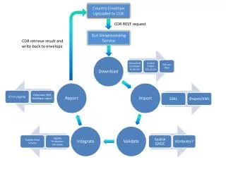
11. Government 2.0, Commonwealth Spatial Data Initiative (CDSI)
Bahrain Spatial Data Infrastructure (BSDI)
We have a 3-way mash-up using web services technology from ESRI US, DOTARS and ABS data. Gov2.0� Web Services in action
12. ArcGIS Server 9.3.1
Store specific spatial data
Produce the thematic maps dynamically based on the data selection using as equal interval calculation
Overlay the thematic map
ESRI Web Services technology
Mash-up the thematic map with other data supplied by Government
Could use:
ESRI ArcGIS Server Online
Bing Maps
Google maps
Yahoo Maps
Presented through the Space-Time Research SuperVIEW front end
ESRI technology integration
13. Thank you, questions?