Download
1 / 13
130 likes | 299 Vues
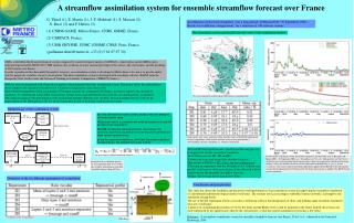
G. Thirel (1), F. Rousset-Regimbeau (2), E. Martin (1), J. Noilhan (1) and F. Habets (3) (1) CNRM-GAME, Météo-France, CNRS, GMME/MC2, France, (2) Direction de la climatologie, Météo-France, France, (3) UMR SISYPHE, UPMC, ENSMP, CNRS, Paris, France

E N D
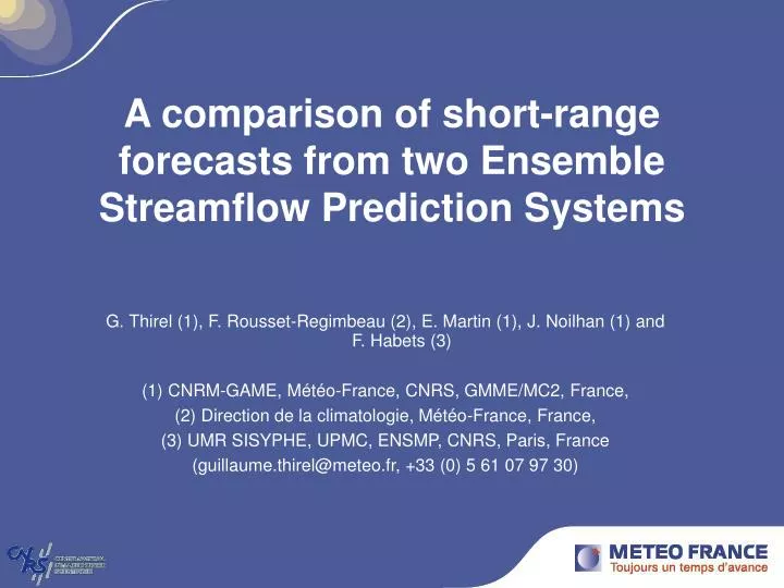
G. Thirel (1), F. Rousset-Regimbeau (2), E. Martin (1), J. Noilhan (1) and F. Habets (3) (1) CNRM-GAME, Météo-France, CNRS, GMME/MC2, France, (2) Direction de la climatologie, Météo-France, France, (3) UMR SISYPHE, UPMC, ENSMP, CNRS, Paris, France (guillaume.thirel@meteo.fr, +33 (0) 5 61 07 97 30) A comparison of short-range forecasts from two Ensemble Streamflow Prediction Systems
Introduction • Every day since 2004 : an Ensemble Streamflow Prediction System (ESPS) based on SIM (hydro-meteorological model) (Rousset, 2007). • over all of France • forced by ECMWF Ensemble Prediction System (EPS) forecasts • medium-range (10 days), validated (more details on a poster, on Thursday, Hall A, 13:30 –15:00) ⇒ Increasing needs for short-range forecasting (Mediterranean region) • A short-range ESPS based on the Météo-France EPS (PEARP) • Short-range (2 days) OBJECTIVES : To compare the impacts of two 2-day EPS forecasts on this ESPS. • ECMWF EPS forecasts • Météo-France PEARP EPS forecasts
The SIM hydro-meteorological model Meteorological analysis SAFRAN Observations + NWP models • PPrecipitation, temperature, humidity, wind, radiations E Surface scheme H ISBA + G Snow Physiographic data for soil and vegetation Qr Qi Nash Daily Streamflow Hydrological model Poor Weak to moderate Good MODCOU Aquifer Habets et al. (2008)
The SIM based ESPS ENSEMBLE FORECASTS ECMWF/PEARP Ensemble forecasts 51/11 members, 2-day forecasts T+ Precip Spatial DESAGGREGATION ENSEMBLE FORECAST SOIL ISBA MODCOU WAT. TABLES RIVERS FINAL STATES ANALYSIS RUN (daily) Observations Meteor. models 10-year climatology Wind, Rad., Humidity SAFRAN SOIL WAT. TABLES RIVERS STATE SOIL WAT. TABLES RIVERS FINAL STATE ISBA MODCOU
The Seine in Paris, March 2001 flood Q90 Q50 Q10 • Correct flood intensity and temporality prediction (rise, date of the flood peak, fall) • Correct spread • Flood prediction as early as 11-12 March : pre-alert, alert
Project outline • Comparison on the first two days of simulation • 569 days of simulation (10 March 2005 – 30 September 2006) • 881 gauge stations compared • Project outline : • The two EPS forecasts used as input • Precipitation disaggregation • Streamflow prediction scores • Conclusions, perspectives
ECMWF 51 members Homogeneous resolution 10 days (+5) Singular vector, leading time 2 days Resolution in operational database 1.5° PEARP 11 members Zoomed version 60 H forecast Singular vectors leading time 12 hours over Europe Resolution in operational database : 0.25° The two EPS forecasts used as input
Precipitation disaggregation • ECMWF : altitudinal gradient (climatological) • 2 mm/m/year where altitude < 800m • 0.7 mm/m/year where altitude > 800m • PEARP : bias removal calibrated over one year Results over the test period : 10 March 2005 – 30 September 2006 Observations (5000 rain gauges) ECMWF (Day 1) PEARP (Day 1) Statistical scores are always better for PEARP than for ECMWF rainfall
BSS low flows (Q10) Blue : ECMWF better with 90% of certainty according to the resampling test Red : PEARP better with 90% of certainty ECMWF : 98 stations PEARP : 184 stations ECMWF : 33 stations PEARP : 329 stations Day 1 Day 2
BSS High flows (Q90) Blue : ECMWF better with 90% of certainty according to the resampling test Red : PEARP better with 90% of certainty ECMWF : 49 stations PEARP : 338 stations ECMWF : 19 stations PEARP : 486 stations Day 2 Day 1
Distribution by basin size (BSS) Q10 Day 1 Q90 Day 1 ECMWF PEARP Basins sizes Basins sizes Q10 Day 2 Q90 Day 2 Basins sizes Basins sizes
Conclusions PEARP disaggregated rainfall was better than ECMWF. The disaggregation method was different for the two EPS (must be adapted to the meteorological model). The PEARP ESPS showed improvements on floods and small scale basins at short-range scale Results confirmed by various statistical scores (RPSS, reliability diagrams, False Alarm and Hit Rates, and a seasonal study.) Interest for flood forecasting in France (SCHAPI) Details of the study in On the impacts of short-range meteorological forecasts for ensemble streamflow predictions, G. Thirel, F. Rousset-Regimbeau, E. Martin, F. Habets, Journal of Hydrometeorology, 2008, Accepted.
Perspectives • Improvement of rainfall disaggregation • Forecast « real » streamflows : • To be compared with observations, not a reference run of the model • Build a realistic initial state for the model : Assimilation of observed streamflows to retrieve a correct soil moisture (description of the method on a poster on Thursday, Hall A, 17:30 - 19:00) Analysis Observation Perturbed simulation Observation Analysed simulation