Download
1 / 1
10 likes | 109 Vues
Analysing, Modelling & Reconstructing Spatial Forest Structure. Arne Pommerening , School of the Environment and Natural Resources, University of Wales, Bangor, Gwynedd, LL57 2UW, United Kingdom, Email: arne.pommerening@bangor.ac.uk. 1. Introduction. 2. System design.

E N D
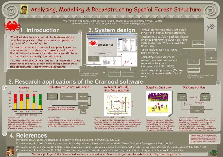
Analysing, Modelling & Reconstructing Spatial Forest Structure Arne Pommerening, School of the Environment and Natural Resources, University of Wales, Bangor, Gwynedd, LL57 2UW, United Kingdom, Email: arne.pommerening@bangor.ac.uk 1. Introduction 2. System design • Virtual lab for the analysis and recon- struction of spatial forest structure. • Implemented as JAVA package, object- oriented programming (OOP), platform independent (MS Windows, Mac OS, Unix/Linux). • Woodland structures as part of the landscape deter- • mine to a large extent the occurrence and population • dynamics of a range of species. «interface» iPoint2D • Indices of spatial structure can be employed as surro- • gate measures of biodiversity to measure and to monitor • the difference between values ideal for a specific habi- • tat function and currently observed values. • Using modern design patterns • (gang of four). Point2D MarkedPoint2D • Computing a wide variety of • nearest neighbour indices and correlation functions (Pommerening, 2002, 2006). «abstract» Area2D • In order to employ spatial statistics for research into the significance of spatial forest and landscape structure a • flexible approach in bioinformatics is required. SpatialTree «interface» Tree CircularPlot RectangularPlot NonSpatialTree • Modelling point processes (Matérn • cluster, Poisson and Matérn hard- • core). Process Reconstruction UML diagram of the plot inheritance in Crancod . UML diagram of the point and tree hierarchy in Crancod. 3. Research applications of the Crancod software Analysis Evaluation of Structural Indices Sampling Simulation (Re)construction Research into Edge-Bias Compensation Object (forest) Sample trees Original forest Measurements Analysis Sampling error Reconstruction error ? Total error b = 100m b = 150m b = 200m b = 80m Synthesis How well do the indices contribute to a synthesis of forest structure? a = 80m Reconstructed forest a = 100m Model a = 150m Pommerening and Stoyan (2006a) a = 200m Pommerening (2002) Pommerening (2006) Pommerening and Stoyan (2006b) Quantifying spatial woodland structure witha wide range of indices and functions. Deve- loping and testing of new indices and functions. Can be based on full enumerations of populations as well as samples. How well do indices contribute to synthesising spatial woodland structure at the computer? A variant of cellular automata was used as a model driving the synthesis in this study. The treatment of edge trees can affect the estimation of structural indices since they can involve off-plot neighbours. The study investigated whether and in what circumstances edge-correction methods are necessary, and evaluated the performance of six different approaches. Sampling simulation is a method to identify the optimal sampling design and sample size for estimators of spatial woodland structure. Circular, rectangular and relascope (Bitter-lich) sample plots can be simulated. (Re)construction is the process of synthesising spatial forest structure or even the spatial structure of a landscape by means of a stochastic optimisation technique. This paves the way to habitat generators which can become an important aspect of conservation planning. 4. References Financial support for this software project has been gratefully received from the WelshEuropean Funding Office and the Forestry Commission, Wales. Crancod is also a result of the activities of the EFI project centreConForest. Pommerening, A., 2002. Approaches to quantifying forest structures. Forestry75, 306-324. Pommerening, A., 2006. Evaluating structural indices by reversing forest structural analysis. Forest Ecology & Management 224, 266-277. Pommerening, A. and Stoyan, D., 2006a. Edge-correction needs in estimating indices of spatial forest structures. Canadian Journal of Forest Research 36, 1723-1739. Pommerening, A. and Stoyan, D., 2006b. Reconstructing spatial forest structure from inventory data. Journal of Vegetation Science. In preparation. The core package of the Crancod software can be downloaded free of charge from the website http://tyfcoed.bangor.ac.uk.