Download
1 / 16
160 likes | 280 Vues
Large-scale Geoelectrical Measurements to Investigate a Buried Valley and its Interaction to Deep Salt water Intrusion. Andreas Junge 2 , Jörn Schünemann 1 and Thomas Günther 1 1 Leibniz Institute for Applied Geosciences, Hannover, Germany

E N D
Large-scale Geoelectrical Measurements to Investigate a Buried Valley and its Interaction to Deep Salt water Intrusion Andreas Junge2, Jörn Schünemann1 and Thomas Günther1 1Leibniz Institute for Applied Geosciences, Hannover, Germany 2Institute for Geosciences, University of Frankfurt, Germany 20th Salt Water Intrusion Meeting June 23-27, 2008 Naples, Florida, USA
Outline • 1. Introduction • Geology • Previous Measurements • 2. Processing • 3. Results • 4. Conclusions
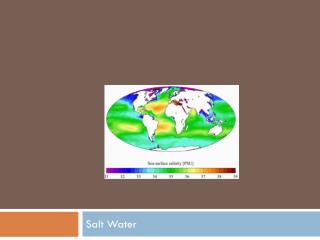
Geology • valley incised into Tertiary • not visible at surface • Quaternary filling: gravel, sand, clay • Lauenburg Clay between 50-70 m depth • important for groundwater supply • depth up to 400 m, width 1-2 km, length approx. 40 km
Previous Measurements • Airborne Electromagnetic Measurements (AEM) • apparent resistivity map of the frequency 1830 Hz • max. depth of 150 m • salt water intrusions near the coast at shallow depth • glacial valley visible due to clay • Geest shows high resistivity Siemon et al., 2001, Identification of salt water Intrusions and Coastal Aquifers Using the BGR Helicopter-borne Geophysical System, SWICA, Morocco
Previous Measurements BurVal Working Group: Kirsch et al., 2006, Groundwater resources in buried valleys - a challenge for geosciences • seismics sees boundary of valley • AEM (full image) and Skytem (columns) results • depth limited due to clay layer => DC measurements • complete electric image of subsurface
Measuring area • 20 receiver stations (red) distances between 500 and 1000 m • 10 transmitter stations (black - E1-E10) • area of 6 km2 • red lines mark buried valley
Station layout and current injection • central electrode + 3 directions • 75 m dipole length • 3 channel MT transient recorder Geolore, sampling rate 8 Hz • injected current 1 to 40 A • square-wave signal of 9 s period • injection time: 20 min
Signalprocessing • removal of anthropogenic and long-periodic noise
Inversion • inversion with FD code DC3dInvRes (Günther, 2004) • homogeneous model, 8 layers: 0-20m, …, 600-800 m • individual weighting of data by errors
1st layer: medium r, 2nd-5th: higher r, 6-8th: medium-low r • layers 5-6: low resistivity on right hand side
clay makes valley visible • clear differentiation between salt water and valley
3D subsurface model with electrode positions • dimensions: 4000 x 3000 x 800 m
clay layer sand Base of Quaternary Tertiary clay and salt water salt water • able to identify clay layer • right hand side: high salt water level • sand with freshwater on left hand side • transition zone under buried valley
clay layer sand salt water
Conclusions • 3D resistivity image by large-scale DC dipole-dipole experiment • gap between seismics and EM closed • clear differentiation between valley and salt water • probably limited infiltration of salt water into valley • different hydraulic conductivities prevent accumulation of salt water in the valley