Download
1 / 32
320 likes | 475 Vues
An Evaluation of Borehole Flowmeters Used to Measure Horizontal Ground-Water Flow in Limestones of Indiana-Kentucky-Tennessee, 1999. Martin R. Risch, presenter, DODEC 2000. U.S. Geological Survey in cooperation with the U.S. Army Environmental Center.

E N D
An Evaluation of Borehole Flowmeters Used to Measure Horizontal Ground-Water Flow in Limestones of Indiana-Kentucky-Tennessee, 1999 Martin R. Risch, presenter, DODEC 2000
U.S. Geological Surveyin cooperation with theU.S. Army Environmental Center John T. Wilson, Wayne A. Mandell, Frederick L. Paillet, E. Randall Bayless, Randall T. Hanson, Peter M. Kearl, William B. Kerfoot, Mark Newhouse, William H. Pedler
Overview of Presentation • Use of Borehole Flowmeters • Project Concept • Description of Flowmeters Evaluated • Evaluation of Flowmeters • Interim Observations
Use of Borehole Flowmeters • Conventional geophysical techniquesidentify bedrock features of potential flow. • Conventional vertical flowmetersidentify bedrock features that actually flow. • Horizontal flowmeters measure direction and velocity of horizontal flow. • Flowmeter data can be used for site assessment, flow models, and remediation planning.
Project Concept • Army Environmental Center has technical oversight of environmental restoration. • Army bases are underlain by limestone bedrock modified by fracturing and dissolution. • Trials with vertical and horizontal heat-pulse flowmeters were favorable. • Evaluation of available horizontal flowmeter techniques was needed.
Description of Directional Borehole Flowmeters Evaluated (Principles, Tools, Methods) • Heat-pulse dissipation (KVA flowmeter) • Video particle tracking (colloidal borescope) • Acoustic attenuation (acoustic doppler velocimeter) • Borehole dilution (hydrophysical logging)
KVA Heat-Pulse Flowmeter Probe tip with heat-pulse generator and thermistor temperature sensors Control box with readout(in thermistor machine-units)
KVA Heat-Pulse Flowmeter Glass beads inside packer Probe with “fuzzy packer”
Colloidal Borescope Probe with cable Probe tip: lens, camera, light
Acoustic Doppler Velocimeter Deployment into well Doppler probe with acoustic emitter and three receivers
Hydrophysical Logging Logging tool with 3 fluid conductivity and temperature sensors Calibration of fluid conductivity probes
Hydrophysical Logging Making Deionized Water Fluid management system
Evaluation of Flowmeters • Study areas: Jefferson Proving Ground, IN and Fort Campbell, KY-TN • Selection of test wells and background geophysical logging • Arrangements for flowmeters & hydrophysics
Jefferson Proving Ground (2) 200-ft, 5-in. wells tested Limestone layer with vuggy porosity & other layers of limestone & shaley limestone Flat upland; 25 ft drift Fort Campbell (3) 161-ft, 6.25 in. wells tested Massive limestone with one to three dissolution-enhanced cavities along bedding planes Rolling hills; karst terrain Study Areas
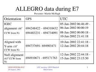
Background Geophysical Logging • Suite of geophysical logs: gamma, formation resistivity, fluid column resistivity, induction, neutron, caliper, and acoustic televiewer. • Identify potential water-producing zones, such as bedding planes, dissolution features, and fractures. • Select zones to be used as measuring points for horizontal flowmeters and hydrophysics.
Logging to identify Vertical Flow Vertical heat-pulse flowmeter
Evaluation Process • Borehole camera used to identify depths forhorizontal flowmeter measurements. • Flowmeter measurements at specified depths in five test wells. • Pumping of nearby well at Jefferson Proving Ground to induce horizontal flow.
KVA Heat-Pulse Flowmeter • Flow velocities 1-4 ft/day at different depths; • Flow velocities and directions variable; • Flow velocity increased and flow directions more variable during pumping of nearby well; • Packer met resistance with borehole wall– no measurements in lower third of some wells; • If packer was loose opposite cavities—vertical leakage affected velocity measurements; • Calculation of aquifer transport velocity (0.7 –0.9 of borehole flow velocity).
Colloidal Borescope • Velocity and direction highly variable except at preferential flow zones; • Consistent measurements opposite permeable rock or fractures, “swirling flow” above and below; • Wider range and larger values for borehole velocity; • During pumping of nearby well, average flow velocity decreased, flow directions consistent in flow zones.
Acoustic Doppler Velocimeter • Downward vertical flow in total length of wells (from falling sediment)—considered suspect; • Adjustment for background noise, up to 3X; • Flow directions & velocities variable through total length of both wells; • Reasonably measured flow direction & velocity of water entering at one fracture and leaving at another.
Hydrophysical Logging • Provides estimates of flow velocity over a range of depths rather than discrete points; • Direction of flow not measured; • Horizontal and vertical flow can be measured; • Volumetric inflow rate (gpm) and velocity were calculated with mass flux analysis of repeated logs of fluid electrical conductivity (FEC); • Indicated connection of flow zones and increased velocity during pumping of nearby well
Hydrophysical Logging - Discharge 0.01 gpm - Velocity 0.1 ft/day (at 42 to 46 ft)
Hydrophysical Logging with Wireline Packer(Paillet, Hess, and Williams, 1998)
Interim Observations • KVA Heat-Pulse Flowmeter • Effective for identifying average horizontal flow directions, especially in absence of vertical flow; • Horizontal flow velocities can be variable, particularly where packer was opposite cavities; • Packer can prevent deeper measurements in some wells.
Interim Observations • Colloidal Borescope • Continuous graphing identifies zones with flow; • Zones with flow show more consistency in velocity and direction; • Multiple exit fractures for vertical flow causes variability in horizontal flow measurements.
Interim Observations • Acoustic Doppler Velocimeter • Experimental, two units in use in USGS; • Lower resolution of 25 ft/day too high for most wells; • Stabilization threshold velocity may need to be smaller; • Standard method needed for “background noise”; • Technology adjustment could have effect.
Interim Observations Hydrophysical Logging • Substantial requirement for logistics, equipment, personnel; • Zones of largest horizontal flow can be identified; • Inflow rates < 0.01 gpm may be below minimumthis method; • Volumetric inflow from hydrophysical logging wassame as vertical downflow estimated with verticalflowmeter.
Interim Observations General • Borehole camera on rods provided exact depths of features for flow measurements. • Methods may not agree because of low flow or vertical flow or both. • Need to convert borehole velocity to aquifer velocity. • Wireline packer could be useful for isolating flow for borescope and doppler.