Download
1 / 1
10 likes | 120 Vues
All models participating in PILPS Phase 2(e) capture the broad dynamics of annual evaporation, snow melt and runoff, but large differences in snow accumulation and ablation, turbulent heat fluxes, and streamflow exist.

E N D
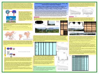
All models participating in PILPS Phase 2(e) capture the broad dynamics of annual evaporation, snow melt and runoff, but large differences in snow accumulation and ablation, turbulent heat fluxes, and streamflow exist. • A significant portion of the Torne-Kalix basin lies above the Arctic Circle and it is consequently characterized by low available energy. Annual net radiation varies between 16 and 40 W/m2. • At high latitudes, available net radiation rather than available water limits latent heat. The majority of the models are able to capture this characteristic. • All models capture the broad feature of the advance of the first snow free day from south to north with snow lingering in the northwest part of the study area. However, the timing of the first snow-free day in the south varies by more than 6 weeks. • The greatest among-model differences in energy and moisture fluxes in these high-latitude environments occur during the spring snowmelt period, reflecting different model parameterizations of snow processes. • Differences in net radiation are governed by differences in the radiative surface temperature during the winter months. • Differences in net radiation are governed by differences in surface albedo during the spring/early summer. • Differences in net radiation are smallest during the late summer when snow is absent. Figure 1. Location of the Torne and Kalix Rivers (red) within the BALTEX domain (white) Mean monthly net radiation versus albedo and radiative surface temperature, and surface temperature versus albedo. The slope of the dashed lines in the first two columns shows how net radiation would change if either albedo or surface temperature were the only control on net radiation. Predicted annual average latent heat flux (1989 – 1998) and estimate from basin water balance Predicted average last day of snow cover (1989 – 1998) and estimate from visual satellite data • The four models with the largest temperature depression in January do not stand out as a group with respect to turbulent and ground heat fluxes. The sensible heat flux is a function of the near surface temperature gradient, the surface roughness and the parameterization of the stability correction, so similar temperature gradients can result in different sensible heat fluxes. • The magnitude of the near surface temperature gradient becomes smaller as the snow disappears. • Similarly, the variability in the near surface temperature gradient, both the among-grid cell variability and the among-model variability, diminishes as the snow disappears. Top: surface temperature depression (land surface temperature minus air temperature). Bottom: Mean January sensible, latent and ground heat flux. Each bar and whisker shows the mean, one standard deviation on either side of the mean and the minimum and maximum value for all 218 model grid cells. Calibration basins runoff statistics • The formulation of aerodynamic resistance and stability corrections in areas of no overstory are at least as important as the sensitivity to representation of canopy interception in explaining intermodel differences in winter evaporation. • Models with the highest effective aerodynamic resistances during the winter simulate the highest total snow accumulation, due to the suppression of turbulent exchanges. • The average snow albedo is less important in explaining between-model differences in cumulative snow sublimation. Annual average melt for two sub-regions of the Torne-Kalix as a function of a) effective aerodynamic resistance and b) average snow albedo. The effective parameters were estimated by fitting equivalent bucket models to reproduce the complex LSS output. Flow duration curves based on daily flows during the period 1989-1998. Land-surface parameterizations in northern regions: Results from PILPS Phase 2(e) Laura C. Bowling and Dennis P. Lettenmaier, Department of Civil and Environmental Engineering, University of Washington, Seattle, WA, USAB. Nijssen, Departments of Civil Engineering and Engineering Mechanics, Hydrology and Water Resources, University of Arizona General Model Performance Abstract Participants: Group I: A. SPONSOR, Russian Academy of Sciences B. RCA, Swedish Meteorological and Hydrological Institute C. IHAS, Frontier Research Center for Global Change, Japan GROUP II: D. SEWAB, GKSS Research Center, Germany E. ISBA, National Center for Atmospheric Research, CNRM, France F. NSIPP, NASA Goddard Space Flight Center G. CLASS, Meteorological Service of Canada H. IBIS, Canadian Forest Service I. CHASM, Macquarie University, Australia J. VIC, University of Washington GROUP III: K. MATSIRO, Frontier Research System for Global Change L. HY-SSiB, NASA Goddard Space Flight Center M. VISA, University of Arizona N. SAST, University of Arizona O. MECMWF, Royal Netherlands Meteorological Institute P. NOAH, NCEP Environmental Modeling Center Q. SWAP, Russian Academy of Sciences GROUP IV: R. SSiB, University of California, Los Angeles S. ECMWF, European Centre for Medium-Range Weather Forecasts T. MOSES-CEH, Centre for Ecology and Hydrology, U.K. U. MOSES, Met Office, U.K. The potential sensitivity of land-atmospheric interactions to climate warming at high latitudes has motivated improvements to parameterizations of cold region processes in land surface schemes used in numerical weather prediction and climate models. PILPS (Project for Intercomparison of Land-surface Parameterization Schemes) Phase 2(e) was designed to evaluate the performance of uncoupled land surface schemes for a high latitude watershed, the Torne/Kalix River system in northern Scandinavia. The Torne and Kalix Rivers drain 58,000 km2 along the border between Sweden and Finland, a domain that was represented by 218 grid boxes at ¼ degree spatial resolution for the ten-year period 1989-1998. Participants were asked to estimate parameters of their models using streamflow observations for two small subcatchments within th Torne/Kalix basin, prior to running models over the entire domain. Streamflow at the basin mouth(s) was not provided to participants, although observations were available for subsequent model evaluation. All twenty-one models participating in PILPS 2(e) were able to capture the broad dynamics of snowmelt and runoff, but large differences in snow accumulation, turbulent heat fluxes and streamflow were apparent. The results showed that limited net radiation in the high latitude environment (varying between 15 and 28 W/m2 on annual average) provides a lower bound on runoff generation. Net radiation during the snow accumulation season is primarily controlled by surface temperature, which in turn influences turbulent fluxes. Those models with the largest negative near surface temperature gradients tend to suppress turbulent fluxes through stability corrections. Although the timing of runoff was dominated primarily by snowmelt, annual runoff volume was controlled in large part by sublimation. Estimates of effective aerodynamic resistances for 13 of the models showed a clear trend toward reduced sublimation and increasing snow accumulation with increasing resistance. Water balance estimate Model Controls on Energy Fluxes Annual average sensible heat versus average latent heat for the 21 PILPS 2(e) LSS. Dashed boxes indicate the basis for division into four groups for interpretation purposes. Forcing Data Calibration Experiment The land surface characteristics provided to participants included spatially distributed (cell-specific) soil textures, elevations, vegetation type and LAI. Hourly meteorological forcings (solar and terrestrial radiation, precipitation, humidity, air temperature and wind speed) were compiled from station data provided by the Swedish Meteorological and Hydrological Institute (SMHI) for the ten year period 1989-1998. The effect of calibration on model performance was explored for two sub-basins, the 566 km2 Ovre Abiskojokk and the 1,341 km2 Ovre Lansjarv. Daily observed streamflow was provided for 1989 through 1998 and modelers were instructed to calibrate their models to the extent possible. • Eleven of the 21 models performed some sort of calibration for these basins. • In almost all cases, the fit of the simulated hydrographs, as measured by the monthly root mean squared error, was improved through calibration. • Improvements in the simulated annual runoff volume were somewhat less pronounced. Mean monthly precipitation from three stations: a) Haparanda, b) Katterjakk and c) Naimakka, versus the corrected precipitation used for PILPS 2(e) and using the correction method derived from the WMO solid precipitation intercomparison project • Even though the largest evaporation rates occur in the summer (June, July and August), inter-model variations in mean annual runoff are primarily related to the model-predicted winter snow sublimation. Models with higher rates of sublimation predict lower annual runoff. • Storage of snowmelt runoff in the soil column primarily influences the timing of the peak rates of both runoff and turbulent fluxes, rather than the absolute magnitude. There is no direct relationship between the ratio of subsurface to surface flow and the volume of annual runoff. • The models with high sublimation generally lose their snow pack too early compared to observations and underpredict annual runoff. These differences in snow sublimation appear largely dependent on differences in snow surface roughness parameterizations. • As is often the case in high latitude studies, the experiment is limited, in part, by the quality of atmospheric forcing data available. Known problems include the following: • Wind-induced errors on the observation of solid precipitation resulted in the under-observation of solid precipitation that was corrected in the gridded dataset; • Sub-daily precipitation data are scarce, so precipitation was disaggregated statistically using the limited available data; and • Incoming radiation components are not regularly observed and must be estimated. An inappropriate estimation technique resulted in a large bias in the original forcing data that had to be replaced after the experiment was underway. • An analysis of the forcing dataset in conjunction with other available data products indicates that there are no significant biases in the final forcing data. • As a group, those models that transferred calibration results to the basin at large (circled below) had a smaller bias and RMSE in their daily streamflow simulations than those that did not. Of the ten models that used transferred calibration results, seven produced acceptable simulations of low flows, compared to only two of the eleven models that did not use calibration parameters. Mean annual snowfall and the proportion lost to melt and sublimation For more information, see the PILPS 2(e) home page, at: http://www.hydro.washington.edu/Lettenmaier/CurrentResearch/PILPS-2e/index.htm. A full description of the PILPS 2(e) experiment design and summary analyses will be available in the following publications: Bowling, L.C., D.P. Lettenmaier, B. Nijssen, L.P. Graham, D.B. Clark, M. El Maayar, R. Essery, S. Goers, Y.M. Gusev, F. Habets, B. van den Hurk, J. Jin, D. Kahan, D. Lohmann, X. Ma, S. Mahanama, D. Mocko, O. Nasonova, G.Y. Niu, P. Samuelsson, A.B. Shmakin, K. Takata, D. Verseghy, P. Viterbo, Y. Xia, Y. Xue, and Z.L. Yang, 2002, Simulation of high latitude hydrological processes in the Torne-Kalix basin: PILPS Phase 2(e) 1: Experiment description and summary intercomparisons, Journal of Global and Planetary Change, accepted. Nijssen, B., L.C. Bowling, D.P. Lettenmaier, D.B. Clark, M. El Maayar, R. Essery, S. Goers, Y.M. Gusev, F. Habets, B. van den Hurk, J. Jin, D. Kahan, D. Lohmann, X. Ma, S. Mahanama, D. Mocko, O. Nasonova, G.Y. Niu, P. Samuelsson, A.B. Shmakin, K. Takata, D. Verseghy, P. Viterbo, Y. Xia, Y. Xue, and Z.L. Yang, 2002, Simulation of high latitude hydrological processes in the Torne-Kalix basin: PILPS Phase 2(e) 2: Comparison of model results with observations, Journal of Global and Planetary Change, accepted. Bowling, L.C., D.P. Lettenmaier, B. Nijssen, J. Polcher, R.D. Koster and D. Lohmann, 2002, Simulation of high latitude hydrological processes in the Torne-Kalix basin: PILPS Phase 2(e) 3: Equivalent model representation and sensitivity experiment, Journal of Global and Planetary Change, in review. Mean annual runoff and the proportion derived from surface and subsurface runoff. The dashed horizontal line indicates observed mean annual runoff. Observed daily average solar insolation at Kiruna: a) versus the PILPS base-run forcing data, b) versus the PILPS rerun forcing data and c) versus the mean annual cycle of rerun forcing data. Simulated and observed mean monthly discharge (1989 – 1998) at the basins mouths