Download
1 / 1
10 likes | 135 Vues
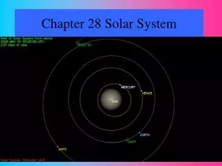
Slanted. Also Rectified. Rectified. The FITS World Coordinate System and its application to STEREO and Solar-B William Thompson, L-3 Communication, NASA/GSFC. What is it?

E N D
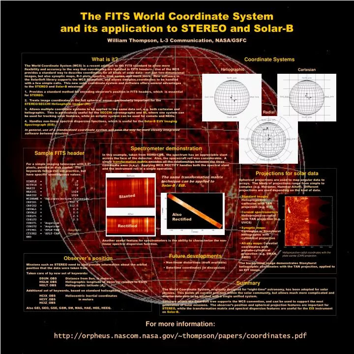
Slanted Also Rectified Rectified The FITS World Coordinate System and its application to STEREO and Solar-B William Thompson, L-3 Communication, NASA/GSFC • What is it? • The World Coordinate System (WCS) is a recent addition to the FITS standard to allow more flexibility and accuracy to the way that coordinates are handled in FITS headers. Use of the WCS provides a standard way to describe coordinates for all kinds of solar data—not just two-dimensional images, but also synoptic maps, R-Ө plots, spectra, time series, and much more. New software in the SolarSoft library supports the WCS formalism, and allows complex coordinates to be handled with a few simple calls. This new solar coordinate system and software offers several advantages to the STEREO and Solar-B missions: • Provides a standard method for encoding observer’s position in FITS headers, which is essential for STEREO. • Treats image coordinates in the full spherical sense—particularly important for the STEREO/SECCHI Heliospheric Imager (HI). • Allows multiple coordinate systems to be applied to the same data set, e.g. both cartesian and heliographic. This is particularly useful for the SECCHI coronagraphs and HI, where one system can be used for tracking solar features, while an ecliptic system can be used for comets and NEOs. • Handles non-linear spectral dispersion functions, which is useful for the Solar-B EUV Imaging Spectrograph (EIS). • In general, use of a standardized coordinate system will pave the way for more closely integrated software between missions. Coordinate Systems Heliographic Cartesian Radial Spectrometer demonstration In this example, taken from SOHO/CDS, the spectrum has an appreciable slant across the face of the detector. Also, the spacecraft roll was considerable. A single transformation matrix encodes all the relationships between the three coordinate axes (λ,x,y). Applying WCS_RECTIFY handles both the spectral slant and the instrument roll in a single operation. Another useful feature for spectrometers is the ability to characterize the non-linear spectral dispersion function. Sample FITS header For a simple imaging telescope with 2.5” pixels, pointed at disk center. The keywords follow current practice, but have specific unambiguous values. SIMPLE = T BITPIX = -32 NAXIS = 2 NAXIS1 = 1024 NAXIS2 = 1024 WCSNAME = ‘Helioprojective-Cartesian’ CRPIX1 = 512.5 CRPIX2 = 512.5 CRVAL1 = 0.0 CRVAL2 = 0.0 CDELT1 = 2.5 CDELT2 = 2.5 CUNIT1 = ‘Angstrom’ CUNIT2 = ‘Angstrom’ CTYPE1 = ‘HPLN-TAN’ (longitude) CTYPE2 = ‘HPLT-TAN’ (latitude) END Projections for solar data Spherical projections are used to map angular data to arrays. The kinds of projections range from simple to complex (e.g. Mercator, Hammer-Aitoff). Different projections are used depending on the kind of data. The background image demonstrates Stonyhurst heliographic coordinates with the TAN projection, applied to an EIT image. The same transformation matrix technique can be applied to Solar-B / EIS. • Standard images: Helioprojective-cartesian with TAN projection (e.g. EIT) • Coronal spectrometers: Helioprojective-radial with TAN projection (e.g. UVCS) • Synoptic maps: Carrington or Stonyhurst heliographic with cylindrical projection • All-sky maps: Celestial coordinates with pseudo-cylindrical projection (e.g. SWAN, SMEI) Helioprojective-radial coordinates with the plate-carrée (CAR) projection. • Future developments • Non-linear distortions (draft available) • Date/time coordinates (in discussion) Observer’s position Missions such as STEREO need to also provide information about the orbital position that the data were taken from Taken care of by new set of keywords: DSUN_OBS Distance from Sun, in meters HGLN_OBS Heliographic longitude of observer relative to Earth HGLT_OBS Heliographic latitude (B0) Additional set of keywords, based on standard heliospheric coordinates, e.g. HCIX_OBS Heliocentric Inertial coordinates HCIY_OBS in meters HCIZ_OBS Also GEI, GEO, GSE, GSM, SM, MAG, HAE, HEE, HEEQ. Summary The World Coordinate System, originally designed for “night-time” astronomy, has been adopted for solar physics. This builds on current practice within the solar community, but allows much more complicated and diverse data sets to be treated with a single unified system. Software within the SolarSoft tree supports the WCS convention, and can be used to support the next generation of solar missions. The observer’s position and spherical projection features are important for STEREO, while the transformation matrix and spectral dispersion features are useful for the EIS instrument on Solar-B. For more information: http://orpheus.nascom.nasa.gov/~thompson/papers/coordinates.pdf