Download
1 / 2
20 likes | 166 Vues
Aquatic Species Irrigation Water Use Potable Water Use Water Supply Water Planning Study. Overview of Water Planning Study.

E N D
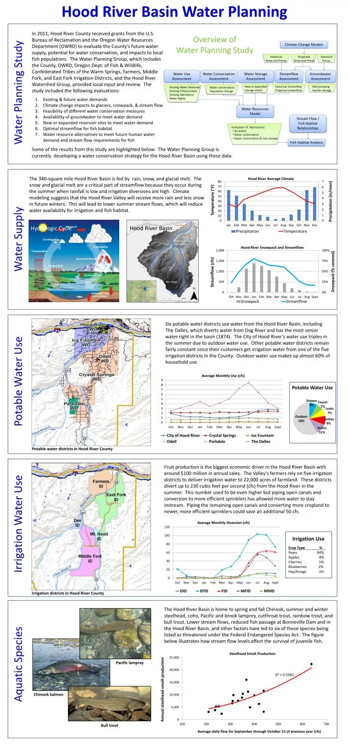
Aquatic Species Irrigation Water Use Potable Water Use Water Supply Water Planning Study Overview of Water Planning Study • In 2011, Hood River County received grants from the U.S. Bureau of Reclamation and the Oregon Water Resources Department (OWRD) to evaluate the County’s future water supply, potential for water conservation, and impacts to local fish populations. The Water Planning Group, which includes the County, OWRD, Oregon Dept. of Fish & Wildlife, Confederated Tribes of the Warm Springs, Farmers, Middle Fork, and East Fork Irrigation Districts, and the Hood River Watershed Group, provided local input and review. The study included the following evaluations: • Existing & future water demands • Climate change impacts to glaciers, snowpack, & stream flow • Feasibility of different water conservation measures • Availability of groundwater to meet water demand • New or expanded reservoir sites to meet water demand • Optimal streamflow for fish habitat • Water resource alternatives to meet future human water demand and stream flow requirements for fish Climate Change Models Historical Temp and Precip. Projected Temp and Precip Historical Precip. Water Use Assessment Water Conservation Assessment Water Storage Assessment Streamflow Assessment Groundwater Assessment New or expanded storage site(s) Historical streamflow Projected streamflow Well pumping Aquifer storage Existing Water Demands Existing Infrastructure Existing Operations Water Rights • Water conservation • Population change Water Resources Model Stream Flow / Fish Habitat Relationships • Evaluation of Alternatives: • No action • Water conservation • Water conservation & new storage Fish Habitat Analysis Some of the results from this study are highlighted below. The Water Planning Group is currently developing a water conservation strategy for the Hood River Basin using these data. The 340-square mile Hood River Basin is fed by rain, snow, and glacial melt. The snow and glacial melt are a critical part of streamflow because they occur during the summer when rainfall is low and irrigation diversions are high. Climate modeling suggests that the Hood River Valley will receive more rain and less snow in future winters. This will lead to lower summer stream flows, which will reduce water availability for irrigation and fish habitat. Hood River Basin Hydrologic Cycle Hood River Basin Water Planning Image courtesy NOAA/Wiki Commons Six potable water districts use water from the Hood River Basin, including The Dalles, which diverts water from Dog River and has the most senior water right in the basin (1874). The City of Hood River’s water use triples in the summer due to outdoor water use. Other potable water districts remain fairly constant since their customers get irrigation water from one of the five irrigation districts in the County. Outdoor water use makes up almost 60% of household use. Potable Water Use Potable water districts in Hood River County Fruit production is the biggest economic driver in the Hood River Basin with around $100 million in annual sales. The Valley’s farmers rely on five irrigation districts to deliver irrigation water to 22,000 acres of farmland. These districts divert up to 230 cubic feet per second (cfs) from the Hood River in the summer. This number used to be even higher but piping open canals and conversion to more efficient sprinklers has allowed more water to stay instream. Piping the remaining open canals and converting more cropland to newer, more efficient sprinklers could save an additional 50 cfs. Irrigation Use Crop Type % . Pears 84% Apples 8% Cherries 5% Blueberries 2% Hay/forage 1% Irrigation districts in Hood River County The Hood River Basin is home to spring and fall Chinook, summer and winter steelhead, coho, Pacific and brook lamprey, cutthroat trout, rainbow trout, and bull trout. Lower stream flows, reduced fish passage at Bonneville Dam and in the Hood River Basin, and other factors have led to six of these species being listed as threatened under the Federal Endangered Species Act. The figure below illustrates how stream flow levels affect the survival of juvenile fish. Pacific lamprey Chinook Salmon Bull trout
By the year 2050 the Hood River Basin is expected to get around 2.3° F warmer. This will lead to more precipitation falling as rain instead of snow, resulting in less snowpack, higher winter streamflows, and lower summer streamflows. Summertime precipitation is also expected to decrease, which will result in even lower summer stream flows and higher crop water demands. The good news is that water conservation has significant potential to protect water availability for potable use, irrigation, and fish habitat. The “East Fork Hood River Summer Streamflow” graph below shows historical (i.e., current) and predicted future stream flows. The red line shows predicted summer stream flow levels in the year 2050 if no conservation measures are taken, whereas the blue line shows flow if all possible water conservation measures are implemented. This includes piping open canals and upgrading 50% of the farms that do not currently have efficient sprinklers. What You Can Do Future Imbalances? Image courtesy NOAA/Wiki Commons Reduce on-farm water use Change out old impact sprinklers to more efficient rotator and micro sprinklers. This is the single most effective action residents can take to ensure there’s enough water for both farming and fish. Plus, you’ll likely be able to receive some assistance for the cost of the new sprinklers. Reduce outdoor water use Water early in the day between 4 and 9 am when evaporation is lowest. The next best time is after 8 pm at night. Avoid watering on windy days. Water infrequently but deeply. This promotes growth of deep root so plants can withstand longer dry periods. Check for leaky sprinklers, hose, broken sprinkler heads, and water lines. Fix them. Never apply water faster than it can be absorbed. Sloped areas are tricky to water effectively. Contour around each plant to create a water well, or use terracing. For new landscapes, choose native drought tolerant plants for water savings and less maintenance. Consider letting your lawn go dormant in summer. It will green up again in the fall. Redirect sprinklers to avoid hitting the pavement. Watering pavement is wasteful. Sweep your driveway or sidewalk instead of hosing it off. Remove weeds regularly and use a weed barrier such as mulch material, bark, or filter fabric. Weeds rob the other plants of water. Mix composted yard trimmings, manure, leaves and other organics into your soil to increase its water retention capacity and nutrients. Reduce indoor water use 1. Upgrade your toilet and showerhead to low flow models. You may be eligible for Energy Star rebates to help cover the cost. Hood River Basin Water Planning For more information please call 386-6063 or visit: http://hoodriverswcd.org/