Download
1 / 31
310 likes | 442 Vues
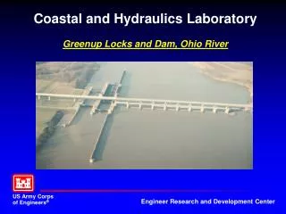
Nutrient Monitoring on the Ohio River: Balancing Information Needs. The Ohio River Basin. 981 Miles long from Pittsburgh, PA, to Cairo, IL Drainage basin covers 204,000 sq. miles in 14 states Basin home to 25+ million people Drinking water for 3 million people

E N D
Nutrient Monitoring on the Ohio River: Balancing Information Needs
981 Miles long from Pittsburgh, PA, to Cairo, IL Drainage basin covers 204,000 sq. miles in 14 states Basin home to 25+ million people Drinking water for 3 million people 120+ species of fish live in the Ohio River 20 dams and 49 power-generating facilities 230 million tons of cargo transported annually Ohio River/ Basin Facts
About ORSANCO • Interstate Compact agency • Member states: Illinois, Indiana, Kentucky, New York, Ohio, Pennsylvania, Virginia, West Virginia. • 3 Commissioners per state plus 3 federal
Authority: Ohio River Valley Water Sanitation Compact • The Compact is incorporated in the laws of each of the member states. • The Compact is also incorporated in Federal law. • The Compact was signed by the Governors and State Commissioners on June 30, 1948.
Guiding Principle: Wastes discharged in one state shall not harm the waters of another state.
Commission Structure 3 Commissioners per State = 24 3 Federal Commissioners = 3 Total Commissioners = 27 Standing Committees Special Committees Program Advisory Committees Advisory Committees ORSANCO Staff Administrative Technical Public Information
ORSANCO Commissioners Represent: • Municipal Utilities (4) • State/Fed environmental agencies (8) • Attorneys (4) • Elected Official (1) • Environmental consultants (3) • Educational institutions (1) • Industry (1)
Current Program Areas • Water Quality Monitoring and Assessment • Biological Studies • Spill Detection and Response • Pollution Control Standards • Public Involvement
Monitoring/Assessment Requirements of the Ohio River VWS Compact • No specific mention • Article I sets water quality goals for interstate waters, pledges states to work cooperatively to reach them. • Article VI sets water quality requirements for intrastate waters. • Implied need – status and trends monitoring/assessment.
Monitoring/Assessment Requirements of the Ohio River VWS Compact • Article VIII charges the Commission to study the pollution problems of the District. • Implied need - any monitoring/assessment effort that identifies causes of water quality problems.
Current Monitoring and Assessment Activities • Monitoring of the Ohio River on behalf of the states • Biennial water quality assessment (305[b]) • Special studies as directed –currently wet weather studies, biological criteria development
Routine Monitoring Programs • Bimonthly ambient monitoring • Bacteria and Dissolved Oxygen • Fish Population studies • Macroinvertebrate sampling • Fish Tissue analyses
ORSANCO Nutrient Related Activities • Algae and Nutrient Monitoring • Nutrient Criteria Development • Participation in Gulf Hypoxia Meetings • Nutrient Loading Project • Organize and coordinate Ohio River Sub Basin Committee
Algae Monitoring • Taste and Odor problems in drinking water supplies • Need for consistent data • Cooperative sampling with water utilities
Nutrient Criteria Development • Need for cause (nutrient) and effect (algae, chlorophyll a) data • Desire for multiple observations to define relationships
Current Algae/ Nutrient Monitoring Program • Cooperative monitoring by ten Ohio River drinking water utilities. • Samples collected two times per month. • Analyses for algae, chlorophyll a, turbidity, total P, TKN, ammonia N, nitrite + nitrate N.
Ecoregions of the Mainstem TN – 2.18 mg/L TP – 0.076 mg/L TN – 0.31 mg/L TP – 0.010 mg/L TN – 0.69 mg/L TP – 0.037 mg/L
Average Phosphorous Concentrations Default USEPA Criteria Ecoregion VI – 0.076 mg/L Ecoregion IX – 0.037 mg/L Ecoregion XI – 0.010 mg/L River-wide Average TP = 0.15 mg/L 0.11 mg/L 0.12 mg/L 0.10 mg/L 0.18 mg/L 0.16 mg/L 0.25 mg/L 0.11 mg/L 0.11 mg/L 0.15 mg/L 0.24 mg/L
Average Nitrogen Concentrations Default USEPA Criteria Ecoregion VI – 2.18 mg/L Ecoregion IX – 0.69 mg/L Ecoregion XI – 0.31 mg/L River-wide Average TN = 1.50 mg/L 1.50 mg/L 1.56 mg/L 1.22 mg/L 1.44 mg/L 1.67 mg/L 2.22 mg/L 1.36 mg/L 1.68 mg/L 1.94 mg/L 1.15 mg/L
ORSANCO Participation in Gulf Hypoxia Deliberations • Attended meetings on behalf of member states since 1995. • Have attended all Task Force meetings. • Full Commission met in conjunction with Task Force in 2002. • Received funding for 1st year of Sub Basin Committee operation in June, 2005.
Actions Assigned to Sub Basin Committees Develop strategies for nutrient reduction for each sub-basin Reduce loadings from point sources Increase assistance to agricultural producers/ businesses for implementation of best management practices
Estimated peak season total nitrogen loads on selected tributaries (lbs/day/sq.mi.)
Information Needs for Gulf Action Plan • Quantify Ohio River nutrient loading to the Mississippi over time. • Quantify tributary loads for prioritization. • Track tributary conditions to assess program effectiveness
Monitoring Program Design Questions • Can current program meet Gulf Action Plan needs? • Can resources be shifted away from criteria development? • Role of probabalistic design