Download
1 / 16
160 likes | 251 Vues
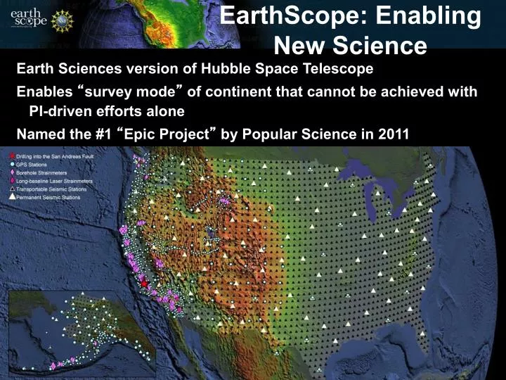
Earth Sciences version of Hubble Space Telescope Enables “ survey mode ” of continent that cannot be achieved with PI-driven efforts alone Named the #1 “ Epic Project ” by Popular Science in 2011. EarthScope: Enabling New Science.

E N D
Earth Sciences version of Hubble Space Telescope Enables “survey mode” of continent that cannot be achieved with PI-driven efforts alone Named the #1 “Epic Project” by Popular Science in 2011 EarthScope: Enabling New Science
“Integrated observational system of systems” (~$200 million) SAFOD: 3.1 km borehole into the San Andreas Fault PBO: 1099 geodetic stations; 81 strainmeter/seismic stations USArray: 2605 seismic and 30 magnetotelluric stations Topographic imaging: 1000s of km2 high resolution topography/InSAR swaths Geochronology: Age dating of wide range of rock types EarthScope: Instrumentation
Exploring the Structure and Evolution of the North American Continent The EarthScope scientific community conducts multidisciplinary research across the Earth sciences utilizing freely available data from instruments that measure motions of the Earth's surface, record seismic waves, and recover rock samples from depths at which earthquakes originate. EarthScope National Office @ ASU: • Foreground Education and Public Outreach • Propel EarthScope science • Community oriented (earthscope@asu.edu)
Synoptic perspective Community data and facilities Hierarchical nesting of focused projects within broad coverage www.earthscope.org
Integrated geodetic and seismic facility cooperative agreement planning UNAVCO will submit a proposal in September 2012 for 2013-2018 Operations and Maintenance including the Plate Boundary Observatory. IRIS will do the same for USArray. The proposals must demonstrate deep community input (the GeoP-ES meetings are an excellent source). Any expansion of purview will come from a fixed level of funding and therefore at the expense of something else important or increased efficiency. UNAVCO/PBO and IRIS/USArray as base infrastructure for expansion and integration. Lay the groundwork now to indicate scientific importance
PBO in green and yellow ANSS backbone in purple
Alaska 2013-2018 272 sites 85 km grid
Alignment of EarthScope and GeoPRISMS science objectives Tentative correlation
NOAA’s Continuously Operating Reference Stations (CORS)--GPS
USArray ground motion visualization Oklahoma earthquake http://www.iris.edu/spud/gmv
Transportable Array • ~1245 stations so far; ~439 to go • ~778 stations removed http://arcserver1.iagt.org/TacoKMZ
Contingent Plans: Canada Canada deployment • ~50 TA stations • ~25 Polaris stations Goals & benefits • Direct observations of key tectonic structures and boundaries • Improve imaging – avoids edge effects by improving the northeast TA footprint • Observe northeastern North America earthquakes at a range of distances (ground acceleration; Q) • Provide framework for focused studies (e.g., FA experiments) • Encourages robust collaboration with Canadians – dividends when USArray deploys to Alaska • Letters of support already helping with provincial lands permitting Status • Recon for Ontario nearly complete • Recon for Quebec next summer ~25 POLARIS stations ~50 TA stations Eastern seismicity 6 years, ~2800 events
TA 1N4 Concept • Concept: leave every fourth TA station behind in central and eastern US • Engage NRC and USGS • Efforts to-date • Provided input to USGS report for NRC • Stakeholder meetings • NSF • US NRC • USGS • State Geologists • DOE • Concept in discussion at OMB and OSTP 1-in-4 (1N4) Create a 250 station permanent network in the central and eastern US by leaving 1 out of every 4 TA stations behind Adoptions allow for the replacement equipment to be more suitable for Alaska deployment