Download
1 / 11
110 likes | 238 Vues
IFORA Îles forestières africaines African Forest Islands. Philippe Le Gall IRD-IRAD Yaoundé Cameroun. ANR -IFORA. Mwanengouba. IFORA Coordinator : Michel Veuille îles forestières africaines - African forest islands Funding agency : ANR-Biodiversité 2007-2009 (France). Member institutions

E N D
IFORAÎles forestières africainesAfrican Forest Islands Philippe Le Gall IRD-IRAD Yaoundé Cameroun ANR -IFORA
Mwanengouba IFORACoordinator : Michel Veuille îles forestières africaines - African forest islands Funding agency : ANR-Biodiversité 2007-2009 (France) Member institutions Belgium U. Libre de Bruxelles Cameroun U. Yaoundé-1 IRAD France CIRAD CNRS EPHE INRA IRD Muséum U. Aix-Marseille U. Montpellier-2 Gabon IRETS Annobon DNA sequencing : 2 CNS Genoscope sequencing projects (France) * Veuille (MNHN-INRA-IRD) ‘Barcoding insects for identification’ (BI4I) 120.000 sequences * McKey (3 joint projects in plant barcoding) 76.000 sequences
Objectives • To establish surveys along the VLC • To understand the high biodiversity of the VLC and the surroundings areas and the biogeography of the taxa involved • To include ecological, biological, geographical and genetic results into a single framework
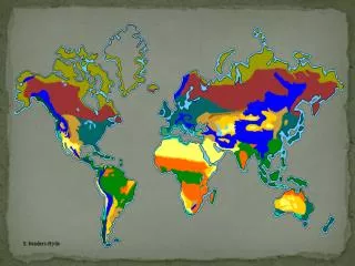
The 25 hotspots of biodiversity to preserve in the world, according to Myers et al. (Nature, 24 March 2000) Western African forests Cameroon volcanic line (CVL)
Adamaoua 1500 m Rumpi Hills 1700 m Bioko, Saõ Tome and Principe Mont Cameroun 4000 m Mont Lefo 2550 m Mont Kupe 2050 m Mont Oku 3000 m Mwanenguba 2000 m
IFORA Les îles forestières africaines - African Forests Islands : the partners
Scientific coordination M. Veuille Task 1 - Role of climate change on biodiversity changes Task 3 - Co-evolution and co-diversification of species Task 2 – Origin and diversification of ecosystems 3-2 Nematodes and chameleon hosts I Ineich 1-1 Pollen analyses of lake deposits AM Lezine 3-1 Ant-plant symbioses D McKey 2-1 Landscape and diversity G Duvallet 2-2 History and current structuring … P Le Gall 2-3 Small ammals: mechanisms … C Denys 3-3 Monogeneans and Cichlid hosts A Gilles 2-4 Diversity of eliaceae and Burseraceae … C Doumenge 2-5 Phylogeography of Forest tree species … O Hardy Task 4 – Barcode : C Laredo Task 5 - Geographic Information Systems and Data bases : C Valton Task 6 - Training and Capacity Building : G Duvallet Key areas Highland forests (Cameroun) Islands from the Gulf of Guinea Lowland forests (Cameroon – Gabon – Equatorial Guinea) Partnership INRA Yaounde Univ. Yaounde herbarium IRAD Libreville herbarium CENAREST IRET ENF Buea U MNHN CNRS IRD CIRAD ULB EPHE
The diversity of the populations of Busseola fusca Busseola fusca is a pest of cultivated cereals. It belongs to a genus widespread in Africa and Asia. It is morphologically similar all over its range of distribution.
The molecular analysis of the Cytochrome b gene revealed the diversity of the populations. Three groups of populations have been documented. They probably diversified around 1 million years BP. The Cameroon population belongs to an East african subgroup and is not linked to the populations from West Africa .
GIS Data are linked in a single type of GIS database which will use the 200 different maps from the IRD collection (Bondy France). The GIS grouped taxonomic (with collection access code), geographical (altitude, longitude, latitude) genetic access code, biological data (e g. hostplant).