Download
1 / 47
620 likes | 851 Vues
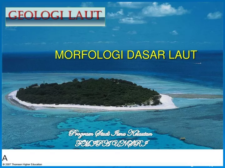
MORFOLOGI DASAR LAUT. GEOLOGI LAUT. Program Studi Ilmu Kelautan FMIPA UNSRI. Fig. 16.38a, p.423. Topograpi dasar laut ??. Bentuk2, pola dan konfigurasi fisik permukaan dasar laut . Kenampakan dasar laut : Kombinasi aktivitas tektonik dan the processes of erosion and deposition.

E N D
MORFOLOGI DASAR LAUT GEOLOGI LAUT Program StudiIlmuKelautan FMIPA UNSRI Fig. 16.38a, p.423
Topograpidasarlaut?? Bentuk2, poladankonfigurasifisikpermukaandasarlaut. Kenampakandasarlaut: Kombinasiaktivitastektonikdan the processes of erosion and deposition.
Dasar Laut Oceans = 71% of the Earth’s surface. Belahan bumi utara: 60% laut, 40% daratan Belahan bumi selatan: 83% laut, 17% daratan. • Four main ocean basins: • Pacific, • Atlantic, • Indian, and • Arctic Laut Pacific Laut paling luas dan paling dalam (average depth ~4,000 meters)
Ocean Basins Arctic Ocean
Bathymetry: Petadasarlaut: • Echo sounding • Multibeam Systems • Satellite Altimetry
Echo sounding : Sound beam emitted by echo sounder (beam angle is exaggerated) Measured depth equals true depth True depth immediately beneath vessel Measured depth is less than actual depth Seafloor Fig. 4-2a, p. 79
Multibeam Systems:Kombinasibanyak echo sounder Multibeam systems : dpt memberikan hasil pengukuran yg lebih akurat. Menggunakan 121 beams radiating from a ship’s hull. Beam ini dapat mengkover sudut 120°
Satellites: Dptdigunakanuntukpemetaankonturdasarlaut Menggunakan satellite altimetry, sea surface levels dapat diukur lebih akurat,
Topografidasarlautbervariasimenurutlokasi Cross sections Atlantic Ocean basin dan the continental United States, menunjukkan range elevasi. Skala vertical exaggeration: 100:1. Although ocean depth is clearly greater than the average height of the continent, the general range of contours is similar.
StrukturDasarLaut • Continental Margin : Continental Shelf (near continent) Continental Slope Continental Rise Submarine Canyons Continental Margins – Bagiansisibenua yang terdapatdibawahpermukaanlaut • Passive margins, disebut Atlantic-type margins, face the edges of diverging tectonic plates. Sangatsedikit/no aktivitas volcanic ataugempabumiygterdapatpadadaerahini. • Active margins, known as Pacific-type margins, terletakdekatsisi converging plates. Active margins tempataktivitasvulkanikataugempabumi. 2.Deep Ocean Basin : Abyssal Plains Oceanic ridges 3. Lain2: aTrenches b Seamounts and Guyots c Atolls
2.Deep Ocean Basin :Abyssal Plains Oceanic ridges 3. Lain2: aTrenches b Seamounts and Guyots c Atolls
Continental slope Continental shelf Continental Shelf Volcanic island Seamount Continental slope Abyssal plain Continental rise trench mid-ocean ridge Rift valley
KenampakanDasarLaut Flat-topped seamounts eroded by wave action are called guyots. Abyssal hills are small, extinct volcanoes or rock intrusions near the oceanic ridges.
Continental Margins Passive Active • Passive continental margins mempunyai continental shelf, continental slope, and continental rise descending to the abyssal plain • Active continental margins have continental shelves and slopes, but the slope extends down into a deep oceanic trench • A mid-oceanic ridge system encircles the globe, typically running down the center of oceans • Banyak gunung laut yang berbentuk kerucut rise from the deep ocean floor
Deep-ocean basin Continental margin Continental margin Submarine canyon profile (cut through continental shelf) Sediment Continental shelf Continental slope Oceanic ridge Sediment Continental rise Continental crust (granitic) Continental crust (granitic) Oceanic crust (basaltic) Oceanic crust (basaltic) Asthenosphere
Narrow continental shelf An active margin A passive margin Peru–Chile Trench Plate boundary Andes Mountains Plate boundary Broad continental shelf South America Atlantic Ocean Pacific Ocean South American Plate Deep basin Nazca Plate African Plate Plate movement Plate movement Plate movement Subduction zone (deep and shallow earthquakes) Mid-Atlantic Ridge (spreading centers, shallow earthquakes) • Atlantic = Passive Margin • little/no geologic activity • Pacific = Active Margin • geologic activity
passive margin NO plate boundary at edge of continent • shelf and slope • continental rise (less steep than slope) • abyssal plain (smooth, deep seafloor)
Continental shelf • Continental shelf: perluasandari continent danberhubungandengandataranpantai, • Kemiringan 0,1derajat • Lebarbeberapa km – 50km, kedalaman 100 – 200 m • UmumnyaSedimenterakumulasipadadaerahini kedaerah C. Slope by: Turbidity current • Sedimenberasaldari continent Terrigeneoussediemet Ditutupiolehsedimenmuda
most material comes from erosion of continent http://media.allrefer.com/s1/l/c0601400-continental-shelf.jpg
Continental slope • Kemiringanbertambahygmenghubungkan the Continental shelf to abyssal plan. • Kemiringan slope 4 – 5 derajat • Kedalamanterusbertambah star 100-200m to 4.000 – 6.000 m
Continental rise • Kemiringansemakinberkurang, 0,5 derajatmenghubungkandasarlaut dg continental shelf. • Masihdianggapbagiandari continental. • Berakhir pd abisal plan pd kedalamankira 5 km • Beradadiatasoseanik crust
Abyssal plains • Abyssal plains daerahdatar yang terdapatdi deep ocean basin floor. • Kenampakanplgdatardibumidengan slope < 0,01 derajat • Umumnyaterletakantara kaki continental rise dan a mid-oceanic ridge. • Kedalaman 4,000 – 6,000 m
Abyssal Plains: Deep, flat areas that are composed mostly of sediment. The Atlantic Ocean has the most substantial. Abyssal plains and abyssal hills cover most of Earth’s surface. • Abyssal plains • 40% of the ocean floor • common in the Atlantic • rare in the Pacific • covered by sediment • Abyssal hills • small sediment-covered extinct volcanos or rock
Abyssal hills • Hills (Bukit2) along the ocean floor. • Tinggidan diameter bervariasi • Kebanyakanlebihbesardibanding bukit2 didarat. • 100-2000 meters high
Seamounts are volcanic projections from the ocean floor that do not rise above sea level. Flat-topped seamounts eroded by wave action are called guyots Abyssal hills are flat areas of sediment-covered ocean floor found between the continental margins and oceanic ridges. Abyssal hills are small, extinct volcanoes or rock intrusions near the oceanic ridges.
Submarine Canyon • Submarine canyons- V-shaped valleys that run across continental shelves and down continental slopes • Deliver continental sediments to abyssal fanson deep sea floor, sometimes by turbidity currents
Submarine Canyons Form at the Junction between Continental Shelf and Continental Slope These are features of some continental margins. They cut into the continental shelf and slope, often terminating on the deep-sea floor in a fan-shaped wedge of sediment.
Oceanic Trenches • Oceanic trench-> daerah sempit, • Palung dalam, parallel thp sisi/tepi continent atau an island arc • Bagian yang paling dalam dari lautan
Mid-Oceanic Ridges • Mid-oceanic ridge - giant undersea mountain range extending around the world like the seams on a baseball • Made mostly of young basalt flows • More than 80,000 km long, 1,500-2,500 km wide, and rises 2-3 km above ocean floor • A rift valley, 1-2 km deep, runs down the crest of the ridge • Shallow focus earthquakes common • Extremely high heat flow • Often marked by line of hot springs, supporting unique biological communities • Offset along transform fracture zones
Mid-Ocean ridge • A mid-ocean ridge is an underwater mountain range, typically having a valley known as a rift running along its spine (punggung), formed by plate tectonics. It is usually an oceanic spreading center,which is responsible for seafloor spreading.
Coral Reefs • Coral (symbiotic coral + alga) are filter feeders, (at present) only live in fairly warm, clear, agitated waters. • Coral reefs are due to accumulation of the calcareous remains of corals and algae, along with minor contributions from other organisms, like sponges and shellfish. • Reefs come in three main types. First two are found in the geologic record, as well as live. Atolls are not found in the geologic record. • Fringe reefs occur along the margins of land. Only conditions needed by coral are necessary for fringe reefs to form. If sea-level is constant, they propagate seaward, leading to barrier reefs. • Barrier reefs occur offshore from land at the surf zone. As a fringe reef grows, the water above it becomes less agitated, a condition necessary for coral. Coral keeps growing in the surf zone, so the live part of a reef can be separated from the land. Fragmented bits of reef fill in the lagoon (quiet water area behind the reef). (Why would this be different for atolls?) • Atolls occur in deep water, and are usually circular rims of reef around a central lagoon. They form as fringe or barrier reefs around an island. The central lagoon is due to karst dissolution of the central part of an originally flat island when sea level was lower during the last glaciation. (We know this because a) we don't find ancient atolls and b) when we drilled a lot into Bikini Atoll, the lower part looked like a perfectly normal fringe reef, and the upper bit looked like it had been karsted, and partially filled in)
other sea floor features seamount conical mountain that rises > 1,000 m above sea floor; basaltic volcanoes; chains of seamounts occur (aseismic ridges) (Emperor seamounts) guyot flat-topped seamount; erosion from waves; reefs common around them
Sea Mount • A seamount is a mountain rising from the ocean seafloor that does not reach to the water's surface (sea level), and thus is not an island. These are typically formed from extinct volcanoes, that rise abruptly.
Volcanic seamounts and guyots project above the seabed • >1 km in height • important fishing areas seamount • about 30,000 • about 10,000 in the Pacific Emperor Seamounts http://upload.wikimedia.org/wikipedia/en/thumb/2/25/Seamount_Locations.png/350px-Seamount_Locations.png
Guyot • A guyot also known as a tablemount, is a flat-topped seamount. Their flatness is due to erosion by waves, winds, and atmospheric processes.
Guyot: flat-topped seamount that once reached the surface http://en.wikipedia.org/wiki/Image:Guyot.jpg
Trench • The oceanic trenches are hemispheric-scale (one hemisphere to another) long but narrow topographic depressions of the sea floor. They are also the deepest parts of the ocean floor.
Mariana Trench • Is the deepest part of the world's oceans, and the deepest location on the surface of the Earth's crust. It has a maximum depth of about 10,911meters, or 11 kilometers.
Atlantic http://www.cryingvoice.com/Evolution/gifs/hydroNA.jpg
Dimana atoll tedapat? • Most of the world's atolls are in the Pacific Oceanand Indian Ocean • The Atlantic Ocean has no large groups of atolls other than eight atolls east of Nicaragua
Atoll • An atoll is an island of coral that encircles a lagoon partially or completely.