Download
1 / 1
10 likes | 159 Vues
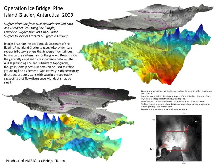
Operation Ice Bridge: Pine Island Glacier, Antarctica, 2009 Surface elevation from ATM on Radarsat SAR data ASAID Project Grounding line (Purple) Lower Ice Surface from MCORDS Radar Surface Velocities From RAMP (yellow Arrows).

E N D
Operation Ice Bridge: Pine Island Glacier, Antarctica, 2009 Surface elevation from ATM on Radarsat SAR data ASAID Project Grounding line (Purple) Lower Ice Surface from MCORDS Radar Surface Velocities From RAMP (yellow Arrows) Images illustrate the deep trough upstream of the floating Pine Island Glacier tongue. Also evident are several tributary glaciers that traverse mountainous terrain on the eastern flank of the glacier. Results show the generally excellent correspondence between the ASAID grounding line and subsurface topography, though in some places OIB data can be used to refine grounding line placement. Qualitatively, surface velocity directions are consistent with subglacial topography suggesting that flow divergence with depth may be small. Upper and lower surfaces vertically exaggerated. Surfaces are offset to enhance visualization Lower surface is bedrock interface upstream of grounding line. Lower surface is ice/ocean interface downstream of grounding line. Digital elevation models constructed using an adaptive kriging technique. Artifacts remain in regions where data is sparse or where surface topographies are complex (e.g. rifts and crevasses). Location and orientations shown in inset map below. upper left Product of NASA’s IceBridge Team