Download
1 / 20
230 likes | 489 Vues
Fleet Weather Center San Diego. Prepared in support of conference entitled, “Mapping, Tracking, & Visualization from Harbors to Deep Oceans 26 Aug 2011. Naval Oceanography Organization. KNOWLEDGE-CENTRIC. MISSION SUPPORT PRIORITY. Maritime Operations. Fleet safety and

E N D
Fleet Weather Center San Diego Prepared in support of conference entitled, “Mapping, Tracking, & Visualization from Harbors to Deep Oceans 26 Aug 2011
Naval Oceanography Organization KNOWLEDGE-CENTRIC MISSION SUPPORT PRIORITY Maritime Operations Fleet safety and near-term operational readiness Aviation Operations Cost of Ownership Fleet Operations Precise Time and Astrometry National missions Navigation ISR Today’s Fight • Naval Oceanography • ~$350M TOA • 6 ships • 1,200 military • 1,300 civilians Naval Special Warfare Cost ofOperations (Effectiveness) Anti-Submarine Warfare Navy Operations Mine Warfare FNMOC USNO NAVO
Battlespace On DemandLinking Forecasts to Decisions Decision Superiority: Making better decisions faster than the adversary
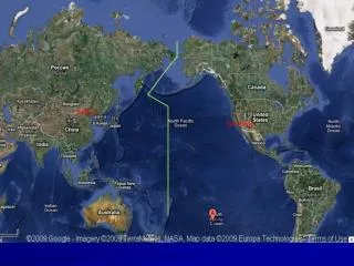
FWC San Diego and FWC Norfolk AORs FWC-N FWC-SD FWC, Norfolk FWC, San Diego Fleet Weather Center San Diego has the Pacific and Indian Oceans AOR’s
Maritime Operations • Optimum Track Ship Routing • - Hazardous weather advisories • - Divert and sortie recommendations • Joint Typhoon Warning Center • - Pearl Harbor, Hawaii • - Tropical cyclone forecasts for Pacific • and Indian Oceans • Routine ship weather forecasts (WEAX) • Aviation weather forecasts for ship-based helicopters (AVWX)
Aviation Operations Core Aviation Weather Services • Flight Route Weather Briefings via Web-based Flight Weather Briefer • Severe weather warnings and advisories for Navy airfields • Terminal Aerodrome Forecasts for Navy airfields
Fleet Operations “Cradle to Grave” support to: • Carrier Strike Group Commanders and ARG • Joint and contingency operations worldwide SGOT = 1 AGC, 3 forecasters, 4 asst MET = 1 forecaster, 1 asst Onboard personnel work with reachback cells to determine: • Optimum fleet maneuvers • Flight operations • Weapons loadout • Target selection
Strike Group Oceanography Teams (SGOTs) Mission: Provide timely, comprehensive, and tactically relevant meteorological and oceanographic (METOC) products and services in direct support of Numbered Fleet / Navy Component Commanders, Assigned Units / Staff, and other U.S. and Joint / NATO/Coalition Forces as directed. • “Sensible Weather” • Aviation Forecast • Maritime Forecast • Satellite Imagery • Upper Air Soundings • BTs • Obs • Tailored Mission Support TDAs: • NITES • PC-IMAT • AREPS • TAWS CVN / LHD / LHA
Naval Oceanography Tools Regional Global High resolution 3D forecast models 3D full physics forecast models Future Local 2D/3D rapidly placed coastal, riverine, and estuary models
Side Scan Sonar Side Scan Sonar Master Contact Database Master Contact Database Pd Map (averaged over4nmifor each grid point) Pd Map (averaged over4nmifor each grid point) Temp: CTD section A - B A B Pd Radials (unaveraged for each grid point) Pd Radials (unaveraged for each grid point) A Historical Imagery Historical Imagery Tactical Imagery Tactical Imagery B Cold core feature Warm core feature Naval Oceanography Tools Collection Assets Annotated and Analyzed Imagery Tactical Products Ocean Modeling Global Regional Local A Kuroshio
Ship Routing Around Heavy Seas Divert track Original track For Demonstration Purposes Only
Joint Typhoon Warning Center Routing Ships around typhoons in the Western Pacific
Hazardous Seas ROGUE WAVES Catastrophic ocean waves, otherwise known as "freak" or "rogue" waves, are towering waves that can measure 30 to 60 feet in height. While always UNEXPECTED, rogue waves tend to occur more often in particular areas, such as off the eastern coast of South Africa. AGULHAS CURRENT WESTWIND DRIFT WESTWIND DRIFT
Using Delft 3D Nearshore Model to Characterize Nearshore Environment
Using Long Range Forecast Tools to Solve Operational Problems
Forecaster Tool Kit 300MB Jet Stream and Vorticity
Maritime Use of Google Earth For Demonstration Purposes Only
Questions? UNCLASSIFIED