Download
1 / 19
190 likes | 304 Vues
ArcServer. Kris Lander Central Region HQ RFC GIS Workshop July 2007. Outline . What is Sever GIS and ArcServer? ArcServer Services Demos. Server GIS Author => Publish => Serve. Server GIS allows GIS capabilities to be delivered to large numbers of users over networks.

E N D
ArcServer Kris Lander Central Region HQ RFC GIS Workshop July 2007
Outline • What is Sever GIS and ArcServer? • ArcServer Services • Demos
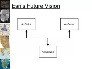
Server GISAuthor => Publish => Serve • Server GIS allows GIS capabilities to be delivered to large numbers of users over networks. • Enterprise GIS users connect to central GIS servers using traditional desktop GIS as well as Web browsers, mobile computing devices, and digital appliances. • Advantages • Flexible applications • Scalable Architecture
What is ArcServer? • ESRI's primary server GIS product. • Maps, Globes and Geocoded data can be shared as a “resource” by ArcServer • A server hosts the data, handles requests for data and allows users to connect to Resources on the server through a variety of client interfaces. • Users can consume services across multiple platforms and actually use the data instead of just “looking” at data
ArcServer Clients • Web • Firefox, IE or any “thin” client • Desktop • ArcGIS,ArcExplorer, Google Earth, GRASS GIS • Mobile • PDA, Smartphone, Laptop • Any device running Pocket PC or Windows CE
Two Development Worlds • .NET • Windows platform • .NET development environment • IIS Server • Java • Linux/Solaris/Windows platform • Java development environment • Apache Server
Services • Map – 2D Map • Globe – 3D Globe • Geocode – Address Matching Jobs • Geodatabase – Access to contents of DB. DB contents can be checked out, edited, and checked back in. • Geoprocessing – Remotely ask to the server to run a model or do geoprocessing • Network.
Map and Globe Service • 2D Clients • ArcGIS Desktop • ArcExplorer • Web API Interface • 3D Clients • Google Earth • ArcExplorer • 3D Client Specs • Data in Cube Projection • Cache on demand or pre-generated cache • Consumers can mix and match services
Geoprocessing Service • A Toolbox or tool layer can be published as a model • Allows organization to centralize data and processes (workflows) • Modelbuilder models are exposed to the client as tasks • Model and data reside on the server • Clients automatically understand the parameter inputs of the models • Supports very thin clients as the processing is handled on the server • Two Processing Modes: • Synchronous: User is locked out of the software while a task is running (ArcGIS Desktop). • Asynchronous: User maintains control of the application while task is running.
Geodata Service • Publish and share data to different locations • Geodatabase replication of http:\\ • Desktop Client (ArcGIS) can be used to extract data, synchronize and replicate
Other Services • Geocoding • Forward and Reverse supported • Network Analyst • Routing etc. • Think Pizza delivery optimization
Improving Service Performance • Map Caching • creates a pre rendered map so that server resources aren’t required to generate data. • 2D and 3D data can be cached. • Good for base maps, aerial photography and data that does not change frequently. • Simplify Mapping to reduce processing requirements • Tune the Service properties
Data Requirements • Map – mxd • Globe – 3dd • Geocode -- .loc file or geodatabase • Geodata – any geodatabase • Geoprocessing -- .tbx or mxd out of the box
Demo Disclaimer • Everything in this Demo was done within the past month • 1 week of ESRI Conference training • Only 40 hours of development time into these applications • No custom programming was required • Nothing is optimized • Most difficult part was setting up software
Demo 1:Web Mapping • Web-based interface • Query Tools • Geoprocessing Tools
Demo 2:Web Service “Mashup” Example • Incorporating Services from Multiple Sources • GIS-1 Server at CRH • Pennsylvania State Data Service • ESRI ArcGIS Online Map Services • Advantage of Fusing and Caching Base Maps
Demo 3:Flood Inundation Example • Free ArcGIS Online 1-m Imagery • Extracting Data to ArcGIS with Geodata Service • Distributed Geodatabase Tools in ArcGIS
Potential NWS Applications • Mobile: Storm damage path surveys or verification for flood inundation mapping • Situation Awareness Tool • Geoprocessing: NWS wide dambreak x-section template and geoprocessing. • GIS Portal and data library