Download
1 / 47
480 likes | 871 Vues
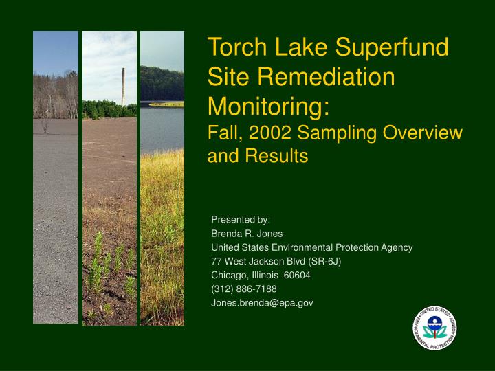
Torch Lake Superfund Site Remediation Monitoring: Fall, 2002 Sampling Overview and Results. Presented by: Brenda R. Jones United States Environmental Protection Agency 77 West Jackson Blvd (SR-6J) Chicago, Illinois 60604 (312) 886-7188 Jones.brenda@epa.gov. Objectives.

E N D
Torch Lake Superfund Site Remediation Monitoring: Fall, 2002 Sampling Overview and Results Presented by: Brenda R. Jones United States Environmental Protection Agency 77 West Jackson Blvd (SR-6J) Chicago, Illinois 60604 (312) 886-7188 Jones.brenda@epa.gov
Objectives • Brief intro to Superfund • Overview of fall 2002 sampling efforts • Summary of results
What is Superfund? Superfund: • Program to clean up hazardous waste sites to protect human health and the environment. • Superfund is managed by the U.S. Environmental Protection Agency • MDEQ Project Mgr: Mary Schafer
Torch Lake Clean-Up Objectives Reduce/minimize: • risks from inhaling airborne stamp sands • risk from contact with or ingestion of slag. • risk of contaminants getting into groundwater • risk of stamp sands released to sediments or surface water
Reduced risk of stamp sands released to sediments or surface water • Protection of benthic orgs • Benthic orgs are part of the aquatic food chain • Stamp sands can interfere with ecological function of the site
Torch Lake Superfund Site Locations 1 = Calumet Lake 2 = Calumet Poor Rock 3 = Boston Pond 4 = North Entry 5 = Michigan Smelter 6 = Quincy Smelter 7 = Isle-Royale 8 = Dollar Bay 9 = Gross Point 10 = Gross Point 11 = Baltic/Atlantic Stamp Mills 12 = Adventure/Trimountain/ Champion Stamp Mills 13 = Torch Lake: Lake Linden, Hubbell/Tamarack Mason sites 13
Blowing Stamp Sands Soil and plant cover over mine waste piles to stop continued erosion of stamp sands into the lake. Thereby speeding up natural recovery of lake’s sediments.
Torch Lake Remedy Objective: prevent further erosion of stamp sands into lake(s) • 6 inches soil with vegetative cover • Vegetation consists of legumes and grasses • Most not native to U.S. or Michigan LegumesGrasses Red clover ryegrass Alfalfa fescue (2 sp) trefoil
1 = Calumet Lake 2 = Calumet Poor Rock 3 = Boston Pond 4 = North Entry 5 = (Michigan Smelter) 6 = Quincy Smelter 7 = (Isle-Royale) 8 = Dollar Bay 9 = Gross Point 10 = Gross Point 11 = Baltic/Atlantic Stamp Mills 12 = Adventure/Trimountain/ Champion Stamp Mills 13 = Torch Lake: Lake Linden, Hubbell/Tamarack Mason sites ____ = completed ( ) = 2003 work in progress Superfund Work Completed 13
Has the habitat been improved due to the remediation? Prior to implementation, the stamp sands were: • poor habitat (fertility, moisture, surface temp) • mostly devoid of vegetation
Good news Adjacent potential source areas
Ecological Study Implemented in 2002 to address the following question: What impact is the remedy having on terrestrial habitats?
2002 Ecological Study • Small mammal survey • Plant survey • Bird survey • GPS - whole site and • all sampling locations
1999 2000 2001 & 2002 2002 Remedy Completion of Four Study Areas
Mammal survey 80 sherman live traps at each location (400 traps) 3 – 4 habitats at each location
Mammal survey • Checked 2x daily for 2 days • Variety of habitats sampled (remediated and unremediated)
Plant Community Survey • Biomass • Root penetration • Fertility • Coverage • Species ID
Plant Community Survey At each of the 5 locations: • 20 random sampling points and • 5 biased sampling point • 3 – 4 distinct habitats • Total = 125 sampling points
Bird Community Observations • Qualitative • Visual • Auditory
Tamarack and Hubbell sites before and after Before Photos: Gary Aho, NRCS
Mason area before remedy Photo credits: Gary Aho, NRCS
2002 Results – Bird Survey # of bird species Lake Linden – 19 Tamarack – 13 Mason – 11 Point Mills – 15 Gay - 15
Results – Plant Survey # plant species • Lake Linden – 17 • Tamarack – 13 • Mason – 19 • Point Mills – 5 • Gay – 7 Total = 76 species ?? Remember we only planted 6 species
Soil Fertility - Calcium Low: 690 – 1130, Med: 1130 – 1570, High: 1570 – 2000, Very High: >2000 From Table 6
Soil Fertility - Magnesium Low: 53 - 93, Med: 94 – 160, High: 161 - 330, Very High: >330 From Table 6
Soil Fertility - Phosphorous Low: 28 - 50, Med: 51 - 80, High: 80 - 153, Very High: >153 From Table 6
Soil Fertility - Potassium Low: 46 - 91, Med: 92 - 162, High: 164 - 310, Very High: >310 From Table 6
Soil Fertility - Copper Low: 0.5, Med: not determined, High: 20, Very High: not determined From Table 6
Results –Mammal Survey # mammal captures • Lake Linden – 15 • Tamarack – 35 • Mason – 20 • Point Mills –0 • Gay – 0 • Gay surrounding area - 55 • At least 15 species (7 trapped) • ~ 15 % trap success • Observed directly or saw signs of: red fox, skunk, deer, black bear, squirrel, raccoon
What does this all mean? Remedial action created diverse habitat where none existed before.
Increased Biodiversity • Biodiversity (number of species) much greater than expected • Biomass (numbers of individuals) much greater than expected • Soil fertility increased after remedy