Download
1 / 1
10 likes | 128 Vues
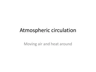
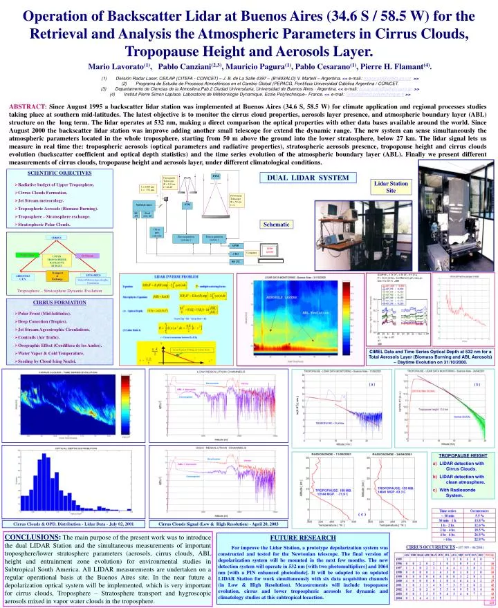
PTM. Cassegrain Telescope F = 8,2 cm f / 16-20. l = 1064 nm l = 532 nm. Newtonian Telescope F = 50 cm f / 2. Nd:YAG laser. PTM. RS - 232. Fixed sync. out. Offset gate controler. Data acquisition system 1. Data acquisition systeme 2. GPIB. Lidar system. CIRRUS.

E N D
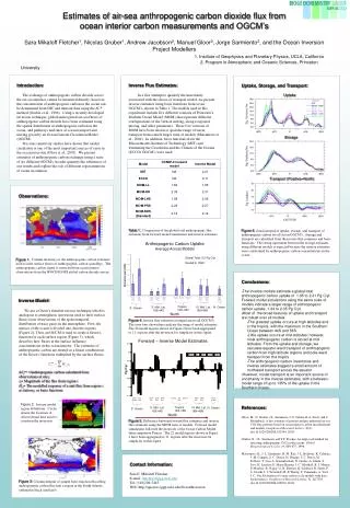
PTM Cassegrain Telescope F = 8,2 cm f / 16-20 l = 1064 nm l = 532 nm Newtonian Telescope F = 50 cm f / 2 Nd:YAG laser PTM RS- 232 Fixed sync. out Offset gate controler Dataacquisition system 1 Dataacquisition systeme 2 GPIB Lidar system CIRRUS Computer // I/O RS 232 Water Vapor Jet Stream UPPER TROPOSPHERE RADIATIVE BUDGET Transport & Exchange DYNAMICS AEROSOLS C.I.N. Vertical Motion Ageostrophic Circulation Troposphere – Stratosphere Dynamic Evolution Operation of Backscatter Lidar at Buenos Aires (34.6 S / 58.5 W) for the Retrieval and Analysis the Atmospheric Parameters in Cirrus Clouds, Tropopause Height and Aerosols Layer.. Mario Lavorato(1), Pablo Canziani(2,3), Mauricio Pagura(1), Pablo Cesarano(1), Pierre H. Flamant(4). (1)División Radar Laser, CEILAP (CITEFA - CONICET) – J. B. de La Salle 4397 – (B1603ALO) V. Martelli – Argentina. <<e-mail: mlavorato@citefa.gov.ar>>(2)Programa de Estudio de Procesos Atmosféricos en el Cambio Global (PEPACG, Pontificia Universidad Católica Argentina / CONICET.(3)Departamento de Ciencias de la Atmosfera,Pab.2 Ciudad Universitaria, Universidad de Buenos Aires - Argentina. <<e-mail: pocanziani@yahoo.com.ar>>(4)Institut Pierre Simon Laplace, Laboratoire de Météorologie Dynamique. Ecole Polytechnique– France. << e-mail: flamant@lmd.polytechnique.fr>> ABSTRACT:Since August 1995 a backscatter lidar station was implemented at Buenos Aires (34.6 S, 58.5 W) for climate application and regional processes studies taking place at southern mid-latitudes. The latest objective is to monitor the cirrus cloud properties, aerosols layer presence, and atmospheric boundary layer (ABL) structure on the long term. The lidar operates at 532 nm, making a direct comparison the optical properties with other data bases available around the world. Since August 2000 the backscatter lidar station was improve adding another small telescope for extend the dynamic range. The new system can sense simultaneously the atmospheric parameters located in the whole troposphere, starting from 50 m above the ground into the lower stratosphere, below 27 km. The lidar signal lets us measure in real time the: tropospheric aerosols (optical parameters and radiative properties), stratospheric aerosols presence, tropopause height and cirrus clouds evolution (backscatter coefficient and optical depth statistics) and the time series evolution of the atmospheric boundary layer (ABL). Finally we present different measurements of cirrus clouds, tropopause height and aerosols layer,under different climatological conditions. • SCIENTIFIC OBJECTIVES • Radiative budget of Upper Troposphere. • Cirrus Clouds Formation. • Jet Stream meteorology. • Tropospheric Aerosols (Biomass Burning). • Troposphere – Stratosphere exchange. • Stratospheric Polar Clouds. DUAL LIDAR SYSTEM Lidar Station Site Schematic • CIRRUS FORMATION • Polar Front (Mid-latitudes). • Deep Conection (Tropics). • Jet Stream Ageostrophic Circulations. • Contrails (Air Trafic). • Orographic Effect (Cordillera de los Andes). • Water Vapor & Cold Temperature. • Seeding by Cloud Icing Nuclei. CIMEL Data and Time Series Optical Depth at 532 nm for a Total Aerosols Layer (Biomass Burning and ABL Aerosols) – Daytime Evolution on 31/10/2000. • TROPOPAUSE HEIGHT • LIDAR detection with Cirrus Clouds. • LIDAR detection with clean atmosphere. • With Radiosonde System. Cirrus Clouds & OPD. Distribution - Lidar Data - July 02, 2001 Cirrus Clouds Signal (Low & High Resolution) - April 20, 2003 CONCLUSIONS:The main purpose of the present work was to introduce the dual LIDAR Station and the simultaneous measurements of important troposphere/lower stratosphere parameters (aerosols, cirrus clouds, ABL height and entrainment zone evolution) for environmental studies in Subtropical South America. All LIDAR measurements are undertaken on a regular operational basis at the Buenos Aires site. In the near future a depolarization optical system will be implemented, which is very important for cirrus clouds, Troposphere – Stratosphere transport and hygroscopic aerosols mixed in vapor water clouds in the troposphere. FUTURE RESEARCH For improve the Lidar Station, a prototype depolarization system was constructed and tested for the Newtonian telescope. The final version of depolarization system will be mounted in the next few months. The new detection system will operate in 532 nm [with two photomultipliers] and 1064 nm [with a PIN enhanced photodiode]. It will be adapted to an updated LIDAR Station for work simultaneously with six data acquisition channels (in Low & High Resolution). Measurements will include tropopause evolution, cirrus and lower tropospheric aerosols for dynamic and climatology studies at this subtropical locaction.