Download
1 / 1
10 likes | 265 Vues
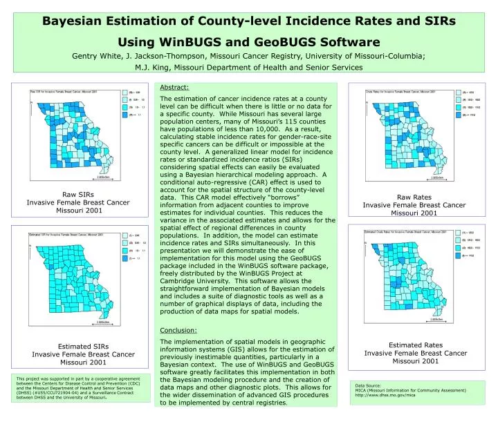
Bayesian Estimation of County-level Incidence Rates and SIRs Using WinBUGS and GeoBUGS Software Gentry White, J. Jackson-Thompson, Missouri Cancer Registry, University of Missouri-Columbia; M.J. King, Missouri Department of Health and Senior Services. Abstract:

E N D
Bayesian Estimation of County-level Incidence Rates and SIRs Using WinBUGS and GeoBUGS Software Gentry White, J. Jackson-Thompson, Missouri Cancer Registry, University of Missouri-Columbia; M.J. King, Missouri Department of Health and Senior Services • Abstract: • The estimation of cancer incidence rates at a county level can be difficult when there is little or no data for a specific county. While Missouri has several large population centers, many of Missouri’s 115 counties have populations of less than 10,000. As a result, calculating stable incidence rates for gender-race-site specific cancers can be difficult or impossible at the county level. A generalized linear model for incidence rates or standardized incidence ratios (SIRs) considering spatial effects can easily be evaluated using a Bayesian hierarchical modeling approach. A conditional auto-regressive (CAR) effect is used to account for the spatial structure of the county-level data. This CAR model effectively “borrows” information from adjacent counties to improve estimates for individual counties. This reduces the variance in the associated estimates and allows for the spatial effect of regional differences in county populations. In addition, the model can estimate incidence rates and SIRs simultaneously. In this presentation we will demonstrate the ease of implementation for this model using the GeoBUGS package included in the WinBUGS software package, freely distributed by the WinBUGS Project at Cambridge University. This software allows the straightforward implementation of Bayesian models and includes a suite of diagnostic tools as well as a number of graphical displays of data, including the production of data maps for spatial models. • Conclusion: • The implementation of spatial models in geographic information systems (GIS) allows for the estimation of previously inestimable quantities, particularly in a Bayesian context. The use of WinBUGS and GeoBUGS software greatly facilitates this implementation in both the Bayesian modeling procedure and the creation of data maps and other diagnostic plots. This allows for the wider dissemination of advanced GIS procedures to be implemented by central registries. Raw SIRs Invasive Female Breast Cancer Missouri 2001 Raw Rates Invasive Female Breast Cancer Missouri 2001 Estimated Rates Invasive Female Breast Cancer Missouri 2001 Estimated SIRs Invasive Female Breast Cancer Missouri 2001 This project was supported in part by a cooperative agreement between the Centers for Disease Control and Prevention (CDC) and the Missouri Department of Health and Senior Services (DHSS) (#U55/CCU721904-04) and a SurveillanceContract between DHSS and the University of Missouri. Data Source: MICA (Missouri Information for Community Assessment) http://www.dhss.mo.gov/mica