Download
1 / 8
80 likes | 177 Vues
Topic 10- GIS layers to web. Outline. GIS data to web What is KML? Conversion of data to KMZ Overlaying KMZ data on web (Google Earth) Convert a kmz file to ArcGIS layer. GIS data to web. Graphic display of GIS spatial data in applications such as Google Earth

E N D
Outline • GIS data to web • What is KML? • Conversion of data to KMZ • Overlaying KMZ data on web (Google Earth) • Convert a kmz file to ArcGIS layer
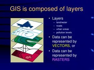
GIS data to web • Graphic display of GIS spatial data in applications such as Google Earth • Layers – features or raster layer converted • Map- map document converted • Process uses conversion to KML for display on web
What is KML? • Keyhole Markup Language (KML) • Format to store geographic data & associated content • Share with non-GIS users on and viewed on Internet using free applications such as Google Earth • Composed of features & raster: points, lines, polygons, and imagery as well as pictures and attributes • KML files are compressed to KMZ format
Conversion of data to KMZ • Tool converts a feature or raster layer into a KML file • containing a translation of Esri geometries and symbology. • File is compressed using ZIP compression, has a .kmzextension • Can be read by any KML client including ArcGIS Explorer, ArcGlobe, and Google Earth. • To access: Arctoolbox> Conversion tools> To KML> Layer to KML Use to convert individual data layer
Conversion of data to KMZ • Tool converts a entire map document (.mxd) into a KML file • containing a translation of Esri geometries and symbology. • File is compressed using ZIP compression, has a .kmzextension • Can be read by any KML client including ArcGIS Explorer, ArcGlobe, and Google Earth. • To access: Arctoolbox> Conversion tools> To KML> Map to KML Use to convert map document
Overlaying KMZ data on web (Google Earth) • Convert to kmz in arcGIS; Open Google Earth and add the kmz file
Conversion of data to KMZ • Tool converts a KMZ file into an ArcGIS layer • To access: Arctoolbox> Conversion tools> From KML> KML to Layer Use to convert KMZ to ArcGIS layer Go to ArcGIS help menu for more info or click: Creating KML in ArcGIS for Desktop