Download
1 / 1
10 likes | 87 Vues
Satellite Earth Surf a ce T emperature: A veraging Proce s s and V alidation

E N D
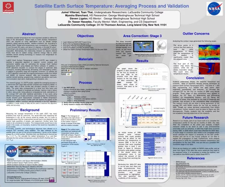
SatelliteEarthSurfaceTemperature:AveragingProcessandValidationSatelliteEarthSurfaceTemperature:AveragingProcessandValidation JumelVillaroel,Tuan Thai,UndergraduateResearchers:LaGuardiaCommunity CollegeMyeshaBlanchard,HS Researcher:GeorgeWestinghouseTechnicalHighSchool Steven Ligator,HS Mentor: George WestinghouseTechnicalHighSchool Dr.YasserHassebo,Faculty Mentor: Math,Engineering,andCS Department LaGuardia Community College: 31-10ThomsonAvenue, Long IslandCity, NewYork 11101 OutlierConcerns Abstract Scientistsconsidertemperaturethemostimportantvariabletodefinethe state of the atmosphere. Global maps of Earth Surface Temperature (EST) are required for many applications such as climate change research,globalwarmingstudies, weatherprediction,etc.Accordingto BerkelyEarth"Globallandtemperatureshaveincreasedby1.5degrees Coverthepast250years,andabout0.9degreesinthepast50years". Performinginsitutemperaturemeasurementfor theglobal ESTis almost impossible. Alternatively, the relationship between an object's internal kinetic heat and its radiant energy (external energy) help to utilize satellites remote sensing technology to measure true temperature for most realobjects. Objectives AreaCorrection:Stage3 The areas bounded bylinesoflongitude andlatitudearenot dividedequally.Asa result, as you move Analyzingthe contourmapsgeneratedthefollowingissues: • LearnAdvanced MATLABProgramming • BuildaStrongStatisticalBackground • Strengthen RemoteSensing Knowledge • ImproveAcademicandNon-Academicskills • ObtaintheEarth’sSurfaceTemperature(EST)fortheyear2000 January,15-20Average The arrow points to a verticallinethatseemsto 70 60 same shows have the 50 temperature. It from toward the the equator 40 Latitude that the temperature at the areas poles get 30 Figure5:Taking theareasintoconsiderationbecause Earth’sgrid isnotdividedinto equalareas the equator is significantly cooler than the adjacentarea. 20 smaller. Materials Oneyearoftemperaturedata(2000)providedbyNationalAeronautic andSpaceAdministration(NASA) NASAresultsfortheyear2000 tovalidatecalculation MATLAB Microsoft Excel Python 10 Results LaGCC Earth Surface Temperature project (L-ESTP) was created to develop a sequential algorithm to organize, correct, analyze, and summarize satellite data for estimating the average Earth Surface Temperature (EST) using Matlab and Python software. In addition, L- ESTP objectives included: (1) conduct five stages of systematic data corrections,includingdetermining,eliminating,andinterpolatingoutliers, inadditiontogeometric(mapandlongitude)correction;(2)validatethe L-ESTPalgorithmresultwiththeongoing temperature resultsfromNASA and NOAA; (3) improve students' skills and knowledge (research, satelliteremotesensing,programming,statisticalcalculationsandtools, communication,team work,reading/writingindiscipline,etc) 20 40 60 80 100 120 140 Longitude 2000.01.01.0000 70 The blue part of this contour map shows the outliers, while the red 60 50 The graph shows the progressindatacorrection for the first six months of the year 2000. As we proceed from raw data analysis to the last stage Latitude 40 shows This could skew the reasonable values. 30 20 10 temperatureresults. 20 40 60 80 Longitude 100 120 140 Conclusion of data correction, the obtained average EST of be Process Students understood, deeply, the essential theoretical and scientific ideas of Satellites Remote Sensing techniques to measureEarth SurfaceTemperature(EST). Thetotalof 1,424 files representing 14.7 million real data points were organized, summarized, and analyzed to calculate the averaged EST for the first six months of 2000 using Matlab program. Three stages of data corrections were applied to analyze the EST data: (1) determining and eliminating Outliers, (2) Interpolating Outliers, and (3) Taking the variationofareas,thatboundedbythelinesoflongitudeand latitude, into account in the calculations (Map corrections). Theresearchresultsdidnotshowastrongagreement,ofthe average EST, with NASA’s results for the first six months of 2000. Though our values deviated substantially from NASA’s calculations,furtherresearchmustbedonetofigureoutthis discrepancies. Finally, students met the academic and the non-academiclearningobjectivesof theresearch. Theresearchgroup,inL-ESTPproject,appliedtheaveragingprocessto awell-knownESTlargedatasetthatcompiledandmergedbyNASA.In this stage, data of three months was provided (January to March of 2000). The given data corresponded to a three hour time frame and boundedby2.5degreeoflongitudeandlatitude,makingatotalofabout 8milliondatapoints.Usingadvancecomputationaltools,estimationsof the average EST and other statistical parameters, in four cases using differenttechniquesofdatacorrections,werecalculated.Thepreliminary results showed good improvement compared to NASA temperature recordsinthesameperiod.Furtherworkwillexploretheimpactofthe precipitation,wildfire,volcanos,andtheemissivityintheESTalgorithm. Inaddition,awidevarietyofdatawillbeusedtoexaminethealgorithm abilityandaccuracy. shows some concern that investigated. areas need to Use MATLABto: Obtain statisticaldata(mean,standarddeviation, etc.) ValidatestatisticaldatausingPython Identifyoutliers DataCorrection: Stage 1. Eliminate outliers Stage 2. Interpolate and replaceoutliers Stage 3. Areacorrection Verifyarea correction results usingexcel Verifyresearchresults withNASAdata Figure6: Data correction:3stagesof 2004 temperature profile Background Measuring the average temperature of the earth (EST) has many problems that must be overcome. You would think that measuring the temperature in situ (at the source) would be simple, but it is close to impossiblegiventhatthemeasurementwouldhavetobeobtainedwould require huge quantities of people, and equipment. Another factor that needstobeconsideredislocation.Themeasurementswouldhavetobe madeintheocean,onmountains,locationsthatwouldbeimpossibleto doaccurately. Fortunately, scientific, and technological advances have allowed us to measure EST remotely, using satellites. The data collected by the satellitedoesnotgiveusthegroundtemperature;itgivesustheradiant energy(Erad)ofthesurface.ScientiststhenuseBoltzmann’sthermallaw (Erad = σ x Trad 4)to calculate the radiant temperature (Trad), and then calculatethetruesurfacetemperatureusingKirchhoff’sthermallaw(Ttrue =є¼Trad). PreliminaryResults Jan Feb March April May June Stage 1:Thehistogramof 6 RAWData FutureResearch Basedonourresults,partofourfutureworkistocompletethe temperature profile for the last six months of 2000. Any data After the completion of the entire year analysis, in-depth research needs to be done to see if any environmental anomaliessuchasvolcanos,orwildfiresmighthaveoccurred during1999,or2000whichcouldhaveeffectedthe2000data. Afourthstageofcorrectionalsoneedstobecompletedwhich would calculate the impact of emissivity on the EST profile. Another part will be to use Fourier analysis on our data to explain the propagation of heat. Furthermore, more analysis willbedonetoverifythecorrelationbetweentemperatureand precipitationfortheyear2000,andusethatasapossiblefifth correctionstageof ourdata. x10 2.5 NASA C 0 -5 13.33 13.33 14.44 3.89 5.56 rawdatatotherightshows a skewtotheleft whichisdue LAGCC 0C 11.3 10.6 11.1 13.23 14.20 14.79 totheoutliers. Figure2 showsasampleofthedata withtheoutliersincluded. 2 ∆T 0C -16.3 2.73 2.23 1.21 -10.31 -9.23 1.5 Occurrence Figure7: Comparison ofourresultswithNASAfor theyear2000 Stage 2:Theoutlierswere 1 eliminatedandreplaced with An initial review of 1999 showed some volcanic activity that could possibly have had an affect on the extreme low temperature in January 2000. A list of the volcanos that were classified greater than a level 2 are listed in figure 8. Volcanos primarilycauseglobalcooling interpolatedvaluesusing MATLABsoftware.Figure 3 Outliers 0.5 showsthesample dataafter interpolation. Anewhistogramwas generatedalongwitha comparisonoftheresults, Figure4. 0 -1000 -800 -600 -400 -200 Temperture(K) 0 200 400 Figure1: Temperature analysisof Year 2000Raw Data SincewearebasingourvalidityonNASA’sdataprofile,andas seenfromfigure9thisdatahassomevariancesthatneedto beanalyzedfurther.Itisnecessarytoreviewthemethod,and calculationsthat NASAusedto obtaintheseEST’s. References if the plume enters the stratosphere were it can reduce the amount of the Figure8: Volcanicactivity sunsenergyfromwarmingthe surface. Sponsors: NationalAeronauticsandSpaceAdministration(NASA) NASAGoddardSpaceFlightCenter(GSFC) NASAGoddardInstituteforSpaceStudies(GISS) NASANewYorkCityResearchInitiative(NYCRI) Departmentof Education-TheAllianceforContinuousLearning Environmentsin STEM(CILES)grant# P031C110158 LaGuardiaCommunityCollege(LAGCC) • WWW.nasa.gov • http://www.python.org/ • WWW.mathworks.com • • Figure2: Temperature analysisof Year 2000Raw Data Reviewingthe NASAESTdata itcanbeseenthatthereare large inconsistencies from • http://photos.mercurynews.com/2013/05/08/photos-volcanos-the-last- 20-years/#name • http://webcache.googleusercontent.com/search?q=cache:Zpg_yB7-z0cJ:data.giss.nasa.gov/gistemp/tabledata_v3/GLB.Ts%2BdSST.txt+&cd=1&hl=en&ct=clnk&gl=us&client=firefox-a • Jensen, John R..Remotesensing ofthe environment:an earth resourceperspective.2nd ed.Upper Saddle River, NJ: Pearson Prentice Hall, 2007.Print. samemonthyeartoyear,and previous and post temperatures as highlighted. Figure3: Temperature analysisof Year 2000InterpolatedData This also questions the credibilityofthe numbers. Acknowledgements: Dr.WilliamRossow,DistinguishedProfessor, EEdept, CCNY Dr.Jorge Gonzalez,MEProfessor, PIofCILESgrant, CCNY Figure9: NASAESTAverages Figure4: Temperature analysisof Year 2000InterpolatedData