Download
1 / 1

E N D
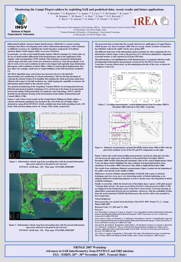
Differential Synthetic Aperture Radar Interferometry (DInSAR) is a remote sensing technique that allows investigating earth surface deformation phenomena (with centimeter to millimeter accuracy) by exploiting the round-trip phase components of Synthetic Aperture Radar (SAR) images relative to an area of interest. In particular, we refer to the Small BAseline Subsets (SBAS) technique [1], which relies on the use of small baseline differential SAR interferograms and on the application of the singular value decomposition (SVD) method. This technique can generate deformation velocity maps and time-series of the area of interest; moreover, it has the peculiarity to be able to work at two-scale resolution in order to investigate both spatially large deformation phenomena (with resolutions of about 100m x 100m) [1] and localized displacements that may affect, for example, small areas or single buildings (at the full instrument resolution) [2]. The SBAS algorithm large scale feature has been proved to be well suited for characterizing and monitoring of volcanic phenomena. This has the big advantage of reducing the amount of data to be handled, thus making the whole processing chain more efficient with respect to the full resolution one, while keeping the capability to measure the deformation signal related to the volcanic activity. The geodetical monitoring of the Neapolitan Volcanic District via an integration between DInSAR and classical geodetic techniques [3] is carried out in the frame of an agreement between the Italian National Institute of Geophysics and Volcanology (INGV) and the Institute for the Remote Sensing of the Environment of the Italian National Research Council (IREA-CNR). Figures 1 and 2 show recent results on the Campi Flegrei (Phlegrean Fields) caldera, a volcanic and densely populated area located to the west of the city of Naples (Italy), obtained by using all the ENVISAT ASAR available data from both ascending (track: 129 - frame: 810) and descending (track: 36 - frame: 2781) orbits, respectively. Figure 1 - Deformation velocity map from ascending data with the ground deformation time-series referred to the pixel in red (red star). ENVISAT ASAR data - IS2 - Time span: 13/11/2002-29/08/2007 Figure 2 - Deformation velocity map from descending data with the ground deformation time-series referred to the pixel in red (red star). ENVISAT ASAR data - IS2 - Time span: 07/11/2002-10/05/2007 The processed data revealed that the recently detected new uplift phase of Campi Flegrei, which became very clear in summer 2005 with an average velocity of about 2.8 mm/year, has definitely reduced the uplift velocity since spring 2007. The different behaviour of the deformation pattern pointed out when comparing the two deformation velocity maps, is due to the presence of a well known planimetric component of ground motion, as also reported in [3] from GPS data. This deformation event highlighted by SAR Interferometry is consistent with the results of independent deformation measurements carried out by the INGV-Osservatorio Vesuviano (Vesuvius Observatory) on the monitoring networks of the area, as shown in the figures 3 and 4 [4]. Figure 3 - Levelling measurements: vertical displacements from November 2004 to December 2006 referred to May 2004 - Coast line Figure 4 - Tiltmetric measurements: ground tilt (DMB station) from 1996 to 2007 with the plot of the resultant vector of the NS and EW components on the right Figure 3 shows the results from levelling measurements carried out along the coast line (see the box in the upper part of the figure) in the period from November 2004 to December 2006: besides indicating the maximum value of the vertical displacement (about 5 cm), the figure clearly highlights the time evolution of ground deformation, from subsidence in November 2004 (referred to May 2004) to uplift till December 2006. The results from continuous tiltmetric measurements (figure 4) point out the beginning of the uplift event already in the middle of 2004. Differences, in terms of limits and potentialities of InSAR with respect to classical techniques and vice-versa, are a very interesting matter of debate indicating, as an optimal solution for monitoring purposes in active volcanic areas, the integration of all the available techniques. Finally we note that, within the framework of the Italian Space Agency (ASI) pilot project “Volcanic Risk System”, the most recent SBAS ENVISAT data processed at IREA-CNR are displayed in the Monitoring Center of the INGV-Osservatorio Vesuviano through an optical fibre connection between the two Institutes. Moreover, with the availability of data from the newly launched COSMO-SkyMed sensor, this activity will be also extended to the X-band data. Acknowledgments Data processing was carried out in the frame of the INGV-DPC Project V3_2 - Campi Flegrei 2005-2007. Research Units: V3_2/01 and V3_2/06. References [1] P. Berardino, G. Fornaro, R. Lanari, E. Sansosti “A new Algorithm for Surface Deformation Monitoring based on Small Baseline Differential SAR Interferograms”, IEEE Transactions on Geosci. and Remote Sensing, 40-11 (2002) 2375-2383. [2] R. Lanari, O. Mora, M. Manunta, J. J. Mallorquí, P. Berardino, E. Sansosti “A Small Baseline Approach for Investigating Deformations on Full Resolution Differential SAR Interferograms”, IEEE Transactions on Geosci. and Remote Sensing, 42-7 (2004) 1377-1386. [3] Lanari R., Berardino P., Borgström S., Del Gaudio C., De Martino P., Fornaro G., Guarino S., Ricciardi G.P., Sansosti E., Lundgren P. “The use of IFSAR and classical geodetic techniques for caldera unrest episodes: application to the Campi Flegrei uplift event of 2000”. Journal of Volcanology and Geothermal Research, 133 (2004) 247-260. [4] C. Ricco, I. Aquino, S. Borgström, C. Del Gaudio “The study of the tiltmetric inversion recorded from July to October 2006 at the Phlegrean Fields (Naples, Italy)” Annals of Geophysics, (2007) in press. Monitoring the Campi Flegrei caldera by exploiting SAR and geodetical data: recent results and future applicationsP. Berardino (1), S. Borgström (2), I. Aquino (2), F. Casu (1), C. Del Gaudio (2), R. Lanari (1), M. Manunta (1), M. Manzo (1), A. Pepe (1), S. Pepe (1), G. P. Ricciardi (2), C. Ricco (2), E. Sansosti (1), G. Solaro (2), P. Tizzani (1), G. Zeni (1)(1) Istituto per il Rilevamento Elettromagnetico dell’Ambiente (IREA) - National Research Council of Italy (CNR), via Diocleziano 328, 80124 Naples, Italy.(2) Istituto Nazionale di Geofisica e Vulcanologia - Osservatorio Vesuviano, via Diocleziano 328, 80124 Naples, Italy. Sezione di Napoli Osservatorio Vesuviano * * FRINGE 2007 WorkshopAdvances in SAR Interferometry from ENVISAT and ERS missionsESA - ESRIN, 26th - 30th November 2007, Frascati (Italy)