Download
1 / 20
240 likes | 644 Vues
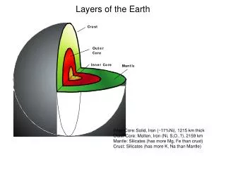
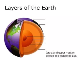
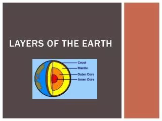
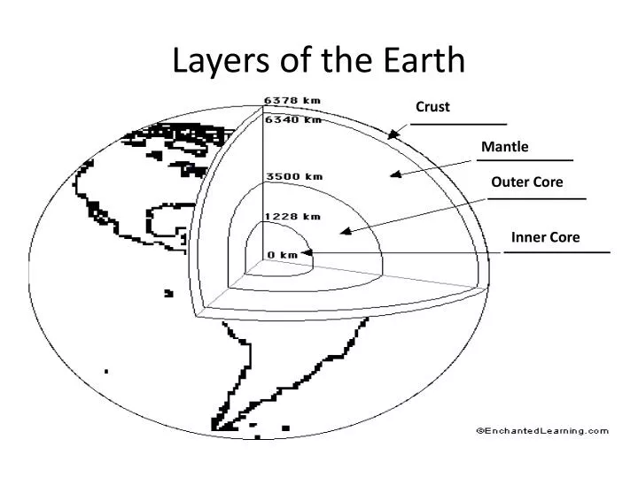
Layers of the Earth. Crust. Mantle. Outer Core. Inner Core. Alfred Wegener’s theory of Continental Drift. Wegener believed that all the earth’s continents were once joined together in a supercontinent call Pangaea.

E N D
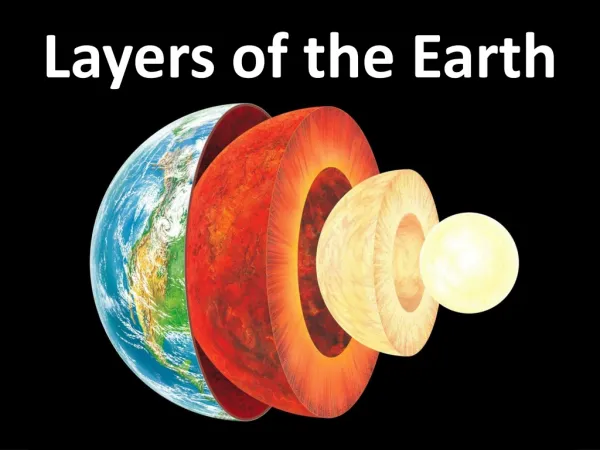
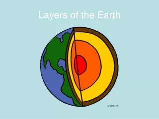
Layers of the Earth Crust Mantle Outer Core Inner Core
Alfred Wegener’s theory of Continental Drift • Wegener believed that all the earth’s continents were once joined together in a supercontinent call Pangaea. • Over 100 million years ago, Pangaea began to split apart and the continents are still moving today.
Evidence for Wegener’s Theory • The shapes of the continental lands masses looked like they had once fit together like a puzzle. • The presence of fossils in rocks now separated by oceans. • Matching magnetic bands on either side of the Mid-Atlantic Ridge. • Fossils of sea animals have been found high in the rocks of the Himalayas.
Chapter Definitions Plate- A section of the earth’s crust. Plate Tectonics- The theory that the earth’s plates interact to produce mountains, trenches, earthquakes, and volcanoes. This happens through convection currents and plate movement. Subduction Zone- An arte of the earth’s crust where one plate slide beneath another, creating volcanoes and earthquakes.
Definitions Continued Topography-The natural features of the land’s surface. Landscape- An area’s landforms together with its cover of vegetation, water, ice, and rock. Geology- Refers to the types of rocks and the history of those rocks. Meteorology- The science of weather. Climate- How we describe the patterns of weather conditions over the long term. Jet Stream-A high and fast wind that flows east across North America along the Canada/U.S. Border.
What Direction is the North American Plate moving? • The North American Plate is moving westward at a rate of 2-4cm per year. • It is separating from the Eurasian Plate along the Mid-Atlantic Ridge, an area of seafloor spreading.
How are landforms built? Convection currents These currents in the mantle cause magma to sometimes break through the crust as lava and volcanic ash, creating new land forms. The currents also cause plates of the earth to separate and collide at their edges. Where they separate trenches are formed and where they collide mountains are formed.
What Forces Shape Canada’s Topography • The building up forces of mountain building • The wearing down forces of weathering, or exposure to the atmosphere. • The wearing down forces of erosion. • The building up forces of deposition, where eroded materials add new shapes.
Canada’s Landform Regions Canadian Shield • 4 billion years old • Canada’s oldest rock • formed by volcanoes,moving water, ice and plate movements • Has thin acidic soil called podzols, and has coniferous forest. • Covers much of Central Canada, west to Saskatchewan and east to Labrador.
Appalachian Mountains • Formed in the east 37 million years ago • Warn down by ice & water creating rolling hills • Deep fertile soil with forest vegetation containing a mix of coniferous & deciduous trees • Covers the Atlantic region of Canada (N.S, N.B., P.E.I., N.F.L.D.)
Western Cordillera • Formed during the Cenozoic Period • Has mountains that rise to over 3000m • West facing slopes have the fastest growing forest in Canada. • 200-300 year old Douglas fir trees 100+m high & 5m in diameter. • Covers all of B.C., Yukon, and parts of Alberta.
Innuitian Mountains • Located in the far north • Formed in the Mesozoic Era • Has rugged mountains over 200m high, not yet eroded. • Too cold for trees
Arctic Lowlands • Located to the south of the Innuitians mostly in Nunavut • Region of upland plateau surfaces and lowland treeless plains containing tundra, lichens, and moss • Cold dry climate,
Interior Plains • Located between the Shield and the Western Cordillera • Created when inland seas receded between the Paleozoic & Cenozoic eras. • Black soil 25cm deep good for growing wheat • Covers most of Alberta, and large sections of Saskatchewan, Manitoba and NWT
Great Lakes-St. Lawrence Lowlands • Located south of the Shield in southern Ontario and Quebec • An area of plains formed during the Paleozoic era • Flooded 10,000 years ago by the Champlain Sea • Fertile brown earth
Hudson Bay Lowlands • Located within the Shield in northern Ontario & Manitoba • Contains Paleozoic rock up to 2000m deep • Soil is a mix of tundra and podzols supporting swamp forest
Seven Factors that effect climate Latitude- Cold in the northern hemisphere and warm near the equator. Air Masses & Winds- Air masses over water or land take on the characteristics of that area(cold/wet or Hot/dry) They travel from west to east across Canada. Ocean Currents- Move large amounts of heat and cold around the earth Clouds & Precipitation- When water vapour in clouds cool below the temperature when condensation occurs rain, ice and snow may form
Seven Factors Continued Altitude- The temperature changes as altitude increases. Bodies of Water- Being near water can bring changes in temperature and precipitation due to the temperature of the water. Mountain Barriers- The Coast Mountains of B.C. receive high amounts or rain and snow due to the west winds from the Pacific, they also keep the Fraser Plateau relatively dry.
Climate Regions of Canada Dry Climates(B Zones)- Cool category of dry climates with an average temperature of less than 18 degrees C, located in southern Alberta and Saskatchewan Warm, moist Climates(C Zones)- Warm humid summers and mild winters located on the western coast of B.C. Cool, moist Climates(D Zones)- Covers 70% of Canada Polar(E Zones)- Located in the far north and covers 25% of Canada, is a cold dry tundra zone
How Canada’s Climates, Weather & Landforms Influence Our Identity