Download
1 / 19
190 likes | 327 Vues
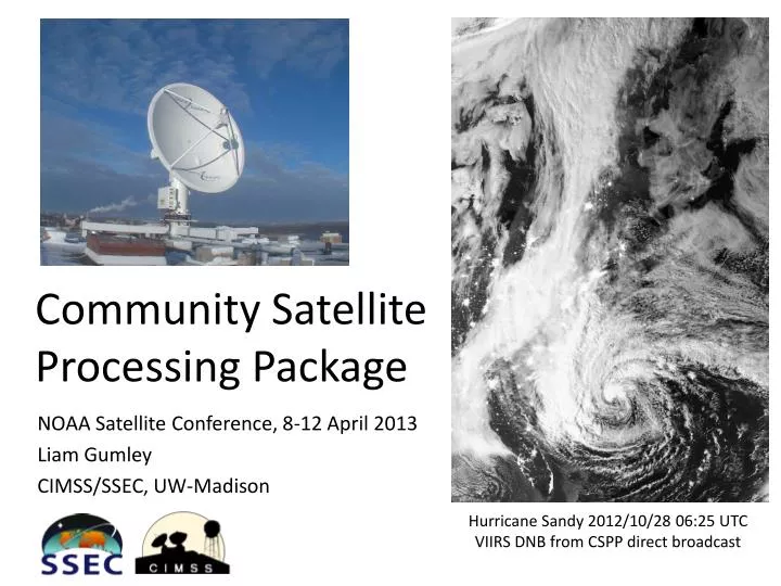
Community Satellite Processing Package. NOAA Satellite Conference, 8-12 April 2013 Liam Gumley CIMSS/SSEC, UW-Madison. Hurricane Sandy 2012/10/28 06:25 UTC VIIRS DNB from CSPP direct broadcast. What is CSPP?.

E N D
Community SatelliteProcessing Package NOAA Satellite Conference, 8-12 April 2013 Liam Gumley CIMSS/SSEC, UW-Madison Hurricane Sandy 2012/10/28 06:25 UTC VIIRS DNB from CSPP direct broadcast
What is CSPP? • The Community Satellite Processing Package (CSPP) is a software system for processing direct broadcast data from polar orbiting meteorological satellites. • Supported satellites include SNPP/JPSS, POES, Metop, Terra, and Aqua. • Developed and supported by CIMSS/SSEC, UW-Madison. • Funded by JPSS Project (Mitch Goldberg). • CSPP Team: Allen Huang (PI), Liam Gumley (PM) Kathy Strabala, Scott Mindock, Geoff Cureton, Ray Garcia, Graeme Martin, Elisabeth Weisz, Nadia Smith, Bill Smith Sr., Nick Bearson, Jim Davies.
VIIRS CrIS CERES ATMS OMPS Limb OMPS Nadir Suomi NPP Sensor Suite HRD X-band Direct Broadcast VIIRS – Medium Resolution Visible & Infra-red Imager CrIS – Fourier Transform Spectrometer for IR Temperature and Moisture sounding ATMS – Microwave sounding radiometer OMPS – Total Ozone Mapping and Ozone Profile measurements CERES - Earth Radiation Budget
First Suomi NPP DB pass acquired by SSEC2.4 meter X/L System, 20:30 UTC, 2012/02/23 VIIRS True Color (M5/M4/M3) VIIRS Infrared (M15)
CSPP for Suomi NPP • CSPP currently includes software for processing of • VIIRS, CrIS, and ATMS SDRs, • VIIRS EDRs, • CrIS single FOV atmospheric profile retrievals, • VIIRS imagery. • Distribution format is executable code and data (ready to run); source code is available in ADL. • Supported host platform is Red Hat Enterprise Linux 5 (64-bit); minimum of 16 GB of RAM is required. • Fast Intel Xeon hardware is recommended for real-time processing.
About CSPP for Suomi NPP • The CSPP software for NPP is based on the Algorithm Development Library (ADL) developed by Raytheon and the JPSS project (the same software that runs in IDPS). • SSEC has packaged the ADL software to run from the Linux command line in real-time direct broadcast mode. We have not changed the underlying processing source code, algorithms, or data formats. • The output files from the CSPP NPP SDR processing software are identical in naming, format, and structure to the corresponding files from IDPS.
Value added features for Suomi NPP • Alternative algorithms, e.g., CrIS DR retrievals. • Optional Granule aggregation, HDF5 internal compression, and mapped quicklook images. • Ancillary data are ingested and processed automatically. • Compiler flags are selected to provide optimized execution speed. • Details of run-time configuration (e.g., XML files) are transparent. • Command line scripts require the name of the directory containing the input files, and nothing else.
CSPP Releases to Date 1. Dec 21, 2011: VIIRS, CrIS, and ATMS SDR beta1. 2. Mar 14, 2012: VIIRS and ATMS SDR v1.0. 3. May 02, 2012: VIIRS, CrIS, and ATMS SDR v1.1. 4. May 04, 2012: CrIS UW DR Retrieval v1.0. 5. Oct 04, 2012: VIIRS, CrIS, and ATMS SDR v1.2. 6. Nov 26, 2012: CrIS, AIR, IASI Hyperspectral Retrieval v1.0. 7. Feb 08, 2013: VIIRS, CrIS, and ATMS SDR v1.3. 8. Feb 08, 2013: VIIRS Cloud Mask and Active Fires EDR v1.0. 9. Feb 22, 2013: VIIRS GeoTIFF and AWIPS Reprojected Imagery v1.0.
CSPP Website http://cimss.ssec.wisc.edu/cspp/
Update 1/7: VIIRS SDR Multi-Processing • Common request from CSPP users is “Can you speed up VIIRS SDR processing?”. • We have tested a multi-processing prototype of CSPP VIIRS SDR. Benchmarks were run on 7 granules (10.0 min) of VIIRS DB data on a fast Intel E5 system. 1 CPU core; 11.6 min 2 CPU cores; 6.8 min 4 CPU cores; 4.0 min 8 CPU cores; 3.3 min (speedup of 350%) • This feature will be available in the next release of CSPP SDR (end of April 2013). Transparent to the end user; activated via command line option.
Update 2/7: CrIS Full Spectral Resolution • CSPP CrIS SDR will support a seamless interrupted transition to FSR mode. • After the switch to FSR, the initial CSPP CrIS SDR product will be identical to current RSR product (FSR is downsampled to RSR). • When FSR calibration processing has been verified in IDPS and offline, it will also be available in CSPP SDR. Current plan is to support both modes (FSR and RSR) in CSPP. • Will be ready for beta testing by end of May 2013.
Update 3/7: VIIRS EDR additions • Have tested VIIRS Aerosol Optical Thickness (AOT), Sea Surface Temperature (SST), and GTM Imagery EDRs in CSPP DB environment. • Independent real-time ancillary data are ingested and granulated at runtime. • Algorithms and LUTs are based on ADL versions of current IDPS algorithms. • Will be ready for beta testing by end of April 2013.
CSPP VIIRS Imagery EDR in AWIPS2 VIIRS I4 Brightness Temp, 09:44 UTC, 16 Jan 2013
Update 4/7: CrIS/IASI/AIRS Retrievals • CSPP HSRTV retrieval package supports SNPP CrIS, Metop IASI, and Aqua AIRS. • Have added and tested Metop-B IASI support. • Have improved detection and handling of AIRS popping channels. • Will be released by end of April 2013.
Update 5/7: CLAVR-X • CLAVR-X creates a suite of Level 2 products including clouds, aerosols, NDVI, and dust. • SNPP VIIRS, POES and Metop AVHRR (AAPP L1B format), and Terra/Aqua MODIS are supported via common algorithms. • Will be ready for beta testing by end of April 2013.
Update 6/7: VIIRS Projected Imagery • Current POLAR2GRID package supports creation of VIIRS visible and infrared imagery at 1.1 km resolution in GeoTIFF and AWIPS formats. • New version supports multiple visible/near-IR/infrared channels for VIIRS and MODIS at full spatial resolution (375 m for VIIRS). • Atmospherically corrected true color images will be available for VIIRS and MODIS. • Will be ready for beta testing by end of April 2013.
Update 7/7: CSPP/IMAPP User’s Group Meeting http://www.ssec.wisc.edu/meetings/cspp


![Advanced Package Processing System [APPS] MTAC – August 2004](https://cdn1.slideserve.com/1720791/advanced-package-processing-system-apps-mtac-august-2004-dt.jpg)