Download
1 / 30
300 likes | 422 Vues
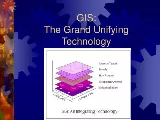
GIS: The Grand Unifying Technology. Introduction to GIS. What is GIS? Why GIS? Contributing Disciplines Applications of GIS GIS functions Information about this course. What is GIS?. It is a: Tool, a science, a software

E N D
Introduction to GIS • What is GIS? • Why GIS? • Contributing Disciplines • Applications of GIS • GIS functions • Information about this course
What is GIS? It is a: • Tool, a science, a software • It is a marriage between computer cartography and database management • It tells you what is where and why • It can model change over time and space. • what is your zip code?
What comprises GIS? • An integration of five basic components People Data Software Hardware Procedures
Contributing Disciplines • Geography • understanding the world and man’s place in it • Cartography-art of map making • display of spatial information • Remote Sensing (define) • images from space and air • source of information for GIS
Contributing Disciplines • Photogrammetry • accurate measurement from photographs • Surveying • high quality positional data • Geodesy- shape of the earth • accurate positional data (control points) • Statistics • GIS models are often statistical in nature
Contributing Disciplines • Computer Science • e.g. CAD, database management • Math • especially geometry and graph theory • Civil Engineering • application driven • roads etc.
Why GIS? • better administration of geographical data • property ownership • tax records • utilities • forests • etc.
Why GIS? • framework for analyzing spatial problems • easy manipulation of map related information • insight into spatial relationships
Why GIS? • better administration of geographical data • property ownership • tax records • utilities • forests • etc.
Applications • Street Network Based • vehicle routing • address matching • site selection
Applications • Natural Resource based • forestry management • wildlife preservation • agricultural land management • wetland preservation
Applications • Land Parcel Based • Zoning • Land Acquisition (greenways) • Water Quality Management
Applications • Facility Management • Utilities (pipes, cables, etc.) • Facility maintenance
You want to buy a house? • Must be close to school. • Must live near a main road. • Would like to live close to urban area. • Would like to live in an area with a low crime rate.
You need to find… • Map showing schools. • Map showing main roads. • Map showing location of urban center. • Map showing insurance zones as a surrogate measure for crime rates.
Capture Store Query Analyze Display Output GIS Functions
Capturing Data Paper Maps GIS Data DigitalData 48585.5, 3759432 Coordinates GPS
Storing Data:Vector & Raster Formats • Database consists of points, lines and polygons • Grid • Cells or pixels
Query • Identifying specific features • I know what but where? Ex. What county is this? • Identifying features based on conditions • I know where but what? • Ex. California counties with population greater than 500,000
Analysis • Proximity – which parcels are within 100 feet of the road? • Overlay- • Well type Drilled • Building owner Smith • Soil type Sandy loam • Network analysis – examines how linear features are connected and how resources flow through them. Traffic flow, water flow
Display • Maps • Graphs • Reports
Output Paper map GIS Data Internet Document Image Texas.mxd Cowboy.jpg
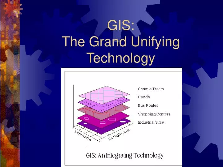
Organizing spatial data • A GIS works with thematic layers of spatial data • Answer questions by comparing different layers of data
Cartography – the science of map making • Scale • Projections • Coordinate Systems • Datums
Topics presented in this class • Introduction to GIS • Introduction to cartographic principles • Models of Reality: Vector and Raster data models • Implementation of a GIS • Spatial Data • Introduction to GPS • Spatial Analysis • Sampling, Error and Uncertainty • Cartographic Design • Future of GIS
Why should you learn GIS? • It is one of the biggest specialized skills in demand today. • It is a multibillion $$$$ industry. • It touches just about every discipline in some way. • It affects your daily life and will do so increasingly in the future.
What should you know about this course? • It will be an adventure. • It will not be presented on a silver platter. • It is technology dependent, and technology does not always work. • If you think the instructors have all the answers, we have some beach front property we would like to sell you. • You are in the drivers seat, what you get out of this class will depend on you. • The Course Goal…