Download
1 / 26
260 likes | 411 Vues
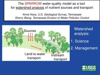
The National Hydrography Dataset Plus a tool for SPARROW Watershed Modeling Richard Moore (presented by Alan Rea). SPARROW (Spatially Referenced Regressions On Watershed Attributes) Described in Smith and others, Water Resources Research, 33(12): 2781-2798

E N D
The National Hydrography Dataset Plus a tool for SPARROW Watershed ModelingRichard Moore (presented by Alan Rea)
SPARROW (Spatially Referenced • Regressions On Watershed Attributes) • Described in Smith and others, Water Resources Research, 33(12): 2781-2798 • An empirical (regression) approach relating observed water-quality data (nutrient loads) to upstream watershed characteristics in a GIS framework • Incorporates variables to simulate in-stream processes • Incorporates only statistically significant parameters.
NHDPlus A digital stream network that is useful as a framework for both water-quality and stream-flow modeling. Has been used to develop the Northeastern and MidAtlantic Region nutrient SPARROW models.
The success of the New England SPARROW originally encouraged the development of NHDPlus. NHDPlus Network
NHDPlus V1 used for SPARROW watershed modeling of nutrient in the Northeastern and Mid-Atlantic Region of the United States
Sparrow Modeling to Understand Water-Quality Conditions in Major Regions of the United States: A Featured Collection
Regional Nutrient SPARROW models developed for 2002 conditions Major River Basin study areas 1 through 5, and 7 published
Regional Nutrient SPARROW models developed for 2002 conditions -- with stream network NHDPlus V1 RF1 (NHDPlus V1 underway) Major River Basin study areas 1 through 5, and 7 published RF1 (NHDPlus V2 underway) RF1 (NHDPlus V2 underway) RF1 (NHDPlus V2 underway) NHDPlus V2 underway RF1 (NHDPlus V2 underway) RF1 = 1:500,000 scale NHDPlus = 1:100,000 scale
Advantages in using NHDPlus NE SPARROW model applications
Advantages in using NHDPlus to build models Provides greater detail A National Seamless Database of topographically derived catchments Mean annual stream flows and velocities “Value Added Attributes” (VAAs) Hydrologic sequence number Identified primary path From and to node navigation Terminal identifier
NHDPlus provides greater detail RF1 2,462 Reaches NHDPlus 72,085 Flowlines (29 x RF1)
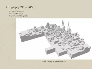
A National Seamless Database 2,613,709 catchments nationally
Catchments are used to compile the predictor variables: Nutrient source variables Land to water delivery variables Regionalization variables
NHDPlus Flow Estimates in cubic feet per second (cfs) Legend SPARROW requires mean annual stream flow and velocity
SPARROW model calibrated based on points, and predictions made for 187,171 stream segments (plus 6156 coastal segments)
4A 4B Phosphorus Nitrogen Kg / ha / year Phosphorus and Nitrogen yields predicted by the Northeastern and Mid-Atlantic regions SPARROW model.
15,600 metric tons/year • SPARROW results are useful in evaluating load assessments to receiving waters Long Island Sound
Predicted Sources of Nitrogen Loading from the Connecticut River Watershed to Long Island Sound
Predicted Nitrogen Load (kg/year) Delivered to Long Island Sound from States within the Connecticut River Watershed
An Example From Narragansett Bay Integration:1) National Coastal Assessment (probabilistic) sampling data, 2) moored instrumentation3) Freshwater Nutrient (NHDPlus –based Sparrow) Modeling4) Estuary Nutrient Mass Balance Calculations EMAP 4/07
New England SPARROW Model Narragansett Bay
Aug 20th Dissolved Oxygen in Narragansett Bay, RI Summer of 2003
Point Sources About 70 % of the TN loadings to the bay were estimated to be from point sources 28 % directly into the bay 42 % from upstream point sources (SPARROW model data) Supports recent management decisions to require tertiary treatment to reduce nitrogen loading to Narragansett Bay
Conclusion NHDPlus data structure is very compatible with freshwater nutrient (Sparrow) modeling, which has many useful applications NHDPlus represents a true partnership effort NHDPlus data website http://www.horizon-systems.com/nhdplus/