Download
1 / 19
210 likes | 414 Vues
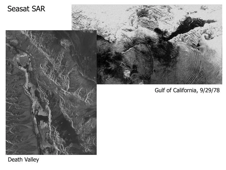
Seasat SAR. Gulf of California, 9/29/78. Death Valley. RadarSat 7/15/98 1513Z. DMSP SSMI 7/15/98 1713Z. DMSP OLS 7/15/98 1713Z. “All images are of the Beaufort Sea. The RadarSat image is focused on the northern part of Banks Island, in the northeastern Beaufort Sea.”

E N D
Seasat SAR Gulf of California, 9/29/78 Death Valley
RadarSat7/15/98 1513Z DMSP SSMI7/15/98 1713Z DMSP OLS7/15/98 1713Z “All images are of the Beaufort Sea. The RadarSat image is focused on the northern part of Banks Island, in the northeastern Beaufort Sea.” “As far as ice types are concerned.....the ice you're seeing in these images are at least 8/10th's of multi-year ice (with the remainder of the ice being <2/10th's first-year thick). If I were to analyze it, I would call it 9-10 / 81 / 74 dot.” National Ice Center Analysis
Ice ReconnaissanceGulf of St Lawrence, Eastern CanadaMarch 6, 1996 Thin first year ice floes (B) and rough "brash ice" (A) are clearly visible as are pressure ridges (C) and cracks or "leads" within first year ice floes (D).
"Sea Empress" Oil Spill MonitoringMilford Haven, Wales, United KingdomFebruary 22, 1996 Ice Type IdentificationGulf of St Lawrence, Prince Edward Island, CanadaMarch 6, 1996
RADARSAT Imagery from September 24 and October 18, 1997 were combined to create this illustration of ice motion in the Slessor Glacier as it flows into the Filchner Ice Shelf in Western Antarctica.
Tokyo Bay Area (Rainbow Bridge, Tokyo Bigsite, etc.) (X-band, VV, 5 km x 4 km, flight direction: right to left, illumination: top to bottom)
Downtown Area of Tokyo (Around Shinjyuku) (X-band, VV, 5 km x 4 km, flight direction: right to left, illumination: top to bottom)
Kansai International Airport (Osaka)(X-band, VV, 5 km x 4 km, flight direction: right to left, illumination: top to bottom)
Surface Properties that Affect SAR Signatures Dielectric Constant (capacitance relative to a vacuum) - MW radars penetrate deeper when the dielectric constant is low (reflect more when it is high). Typical values include 3-16 for dry rocks and soils, 30-60 for moist soils, and up to 80 for water. The Rayleigh criterion states that the height of the surface variation in the direction of the incoming radar, must be less than 1/8th the value of the radar's wavelength to be considered "smooth." Roughness - granular soils, gravel, grass, etc. with representative size of millimeters to centimeters affect the “smoothness” of a surface. Volumetric Scatter - Can produce depolarization effects. http://www.asf.alaska.edu/reference_documents/datacenters_references/scatter.html
Oxford County, Ontario HH Polarization:R=May 22, 1990G=May 23, 1990B=May25, 1990 HH polarized microwaves penetrate vegetation to a greater degree than VV and hence respond to variations in plant volume and underlying soil moisture. This can decrease class separability at low plant density and increase at high density.
Oxford County, Ontario VV Polarization: R=May 22, 1990G=May 23, 1990B=May25, 1990 Vertically polarized microwaves couple with the vertical structure of crops, providing good contrast among different crop types. In this C-VV image, the difference in crop structure and planting dates between winter wheat and rye can be detected. The attenuation of VV microwaves by alfalfa crops separates these fields from other early season crops better than HH.
Oxford County, Ontario, HV polarization:R=May 22, 1990G=May 23, 1990B=May25, 1990 Forested areas act as strong depolarizers of microwave signals and as a result, wooded areas are more easily separated from cropped and bare agricultural fields than with like polarized data.
Teide Volcano • This radar image shows the Teide volcano on the island of Tenerife in the Canary Islands. The Canary Islands, part of Spain, are located in the eastern Atlantic Ocean off the coast of Morocco. Teide has erupted only once in the 20th Century, in 1909, but is considered a potentially threatening volcano due to its proximity to the city of Santa Cruz de Tenerife, shown in this image as the purple and white area on the lower right edge of the island. The summit crater of Teide, clearly visible in the left center of the image, contains lava flows of various ages and roughnesses that appear in shades of green and brown. Different vegetation zones, both natural and agricultural, are detected by the radar as areas of purple, green and yellow on the volcano's flanks. Scientists are using images such as this to understand the evolution of the structure of Teide, especially the formation of the summit caldera and the potential for collapse of the flanks. The volcano is one of 15 identified by scientists as potentially hazardous to local populations, as part of the international "Decade Volcano" program. The image was acquired by the Spaceborne Imaging Radar-C/X-Band Synthetic Aperture Radar (SIR-C/X-SAR) onboard the space shuttle Endeavour on October 11, 1994. SIR-C/X-SAR, a joint mission of the German, Italian and the United States space agencies, is part of NASA's Mission to Planet Earth. The image is centered at 28.3 degrees North latitude and 16.6 degrees West longitude. North is toward the upper right. The area shown measures 90 kilometers by 54.5 kilometers (55.8 miles by 33.8 miles). The colors in the image are assigned to different frequencies and polarizations of the radar as follows: red is L-band horizontally transmitted, horizontally received; green is L-band horizontally transmitted, vertically received; blue is C-band horizontally transmitted, vertically received. R - L-band HH G - L-band HV B - C-band HV
One of the properties of radar pulses gave rise to an extraordinary image acquired from SIR-A in November of 1981. The color scene below is a Landsat subimage of the Selma Sand Sheet in the Sahara Desert within northwestern Sudan. Because dry sand has a low dielectric constant, radar waves can penetrate these small particles to depths of 10 feet (several meters) or more. The inset radar strip trending NE actually images bedrock at that general depth below the loose alluvial sand and gravel which acts as though almost invisible. A channeled subsurface topography is revealed, with valleys correlative to specularly reflecting surfaces and uplands shown as brighter. Here is a movie showing a Landsat image fading into a SIR-C/X-SAR image of the Safsaf Oasis, Egypt http://mercator.upc.es/tutorial/nicktutor_8-7.html
Interferometric SAR (ISAR or IFSAR) essentially produces a stereo SAR view of a scene. This allows extraction of height information.
Interesting SAR Sites SAR Missions Airbone High-resolution Multiparameter Synthetic Aperture Radar (Japan) Heriot-Watt University, Department of Physics SIR-C/X-SAR Space Radar Images of Earth (NASA JPL) Alaska SAR Facility