Download
1 / 36
360 likes | 368 Vues
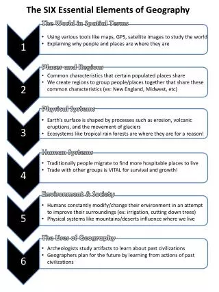
The 6 Elements of Geography Part 1. 6 Elements. Many geographers use the six essential elements to organize their study. The World in Spatial Terms Physical Systems Human Systems Environment and Society Places and Regions Uses of Geography. The World in Spatial Terms.

E N D
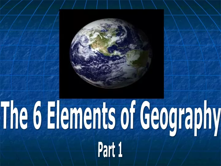
The 6 Elements of Geography Part 1
6 Elements Many geographers use the six essential elements to organize their study. • The World in Spatial Terms • Physical Systems • Human Systems • Environment and Society • Places and Regions • Uses of Geography
The World in Spatial Terms • Geographers look at where things are on the Earth’ssurface. • Changes in settlementpatterns over time are also important.
The World in Spatial Terms It tells us where this place is in relation to other places? Or, its LOCATION
The World in Spatial Terms “Where are we?” • Absolute Location: • Latitude and longitude (global location) • Sugar Land is located at 29°N, 96°W • Street address (local location)
Arctic Circle, 66 1/2ºN North Pole, 90ºN Tropic of Cancer, 23 1/2ºN Tropic of Capricorn, 23 1/2ºS South Pole, 90ºS Antarctic Circle, 66 1/2ºS
Practice • What major city has the following coordinates? • 41ºN, 73ºW (USA) • 33ºN, 13ºE (Africa) • 33ºS, 71ºW • 34ºS, 150ºE • Name the global address of: • Hanoi, Vietnam • Athens, Greece • Tehran, Iran • Sugar Land, TX
The World in Spatial Terms • Relative Location: • Described by landmarks, time, distance from one place to another, etc. • Sugar Land is southwest of Houston • College Station is 1 hr 45 min away • Israel is next to Lebanon & Jordan
Practice Using an atlas, select a city outside of the United States and write down its absolute location. Then, describe its relative location.
Physical Systems • We study the 4 physical systems: Earth’s atmosphere, land, water and life…and the interaction b/w them all • Physical processes shape and change Earth’s physical features and environments. • Climate and weather affect humans.
Physical Systems • Ecosystem: all of an area’s plants and animals together with the nonliving parts of their environment. • Earth is the largest ecosystem. • Natural events and human activity change ecosystems. • All of life depends on these ecosystems…
Physical Systems: • How did Hurricane Katrina influence New Orleans’ population and economy?
Human Systems Human systems include population distribution, growth and movement Population growth is affected by a population’s age, birthrate, death rate, and life expectancy. What kinds of things lead to population growth?
Human Systems Houston traffic • Geographers look at where people live and how crowded a place is when they study population density. • They also study migration or the movement of people. • One specific type of movement is urbanization
MOVEMENT Movement of people, goods, and information & ideas Through travel, trade, internet, political events, etc.
Transportation of humans Immigration/Migration What are some push factors? What are some pull factors?
Environment and Society Pollution in Houston, Texas… on a clear day. • One of the most impt. topics is how people interact with the environment. • Human activities can have positive and negative affects on the environment.
Environment and Society Humans adapt to env.: Name 3 ways humans Δfor the environment Humans modify env.: Name 3 ways humans Δ the environment Humans depend on env.: Name 3 ways humans need the environment
Environment and Society Oil Fields in West Texas • Resources are very impt. to study in relation to people. • Population , demands on resources . • Study the locations, quality, and quantity & and the effect of humans.
Places and Regions Palo Duro Canyon A place has physical and human characteristics that make it special.
PLACE “What is it like?” Physical Characteristics: Mountains, rivers, wildlife, beaches, etc. Describe Texas’ physical characteristics
PLACE Human/Cultural Characteristics: Buildings, roads, clothing, food, people, language, religion, etc Describe New York’s cultural characteristics People then develop an image of the place based on experience What do you imagine when you think of China? Saudi Arabia?
What physical features of Sugar Land make it a unique place? What cultural/human characteristics are unique to Sugar Land?
REGION“How are places similar or different?” definition = area of earth’s surface with similar characteristics Geographers categorize regions in 3 ways: A. formal regions B. functional regions C. perceptual/vernacular regions
REGION Formal (uniform) regions: Defined by govn’t. (USA, Brazil, Texas) Or physical features (Rockies, Great Lake States) Or common characteristic (Corn Belt, Rust Belt)
REGION Functional regions: organized around a set of interactions and connection between places (usually characterized by a hub, or central place, and links to the central place) a newspaper’s distribution route
REGION Vernacular/Perceptual regions: people perceive the characteristics of the region in the same way (loosely defined) The Middle East (what countries are actually included? Is it linked b/c of oil? Islam?) Bible Belt – southeastern states in U.S. = strict Protestants
Perceptual Region • The states in dark red are almost always included in modern day definitions of the Southern United States, while those in medium red are usually included. Those cross-shaded are sometimes included due to their historic connections to the South.
Uses of Geography • Historians use geography to understand history. • Not only do they look at when things happened, but where and why they happened. • Geography helps people understand the present as well as the past.
Uses of Geography • Geographers use many tools including maps, charts, and graphs. High-tech tools such as satellites provide detailed images • Computer databases, like Geographic Information Systems, (GIS) store huge amounts of data. Satellite image of Texas, Louisiana and the Gulf of Mexico