Download
1 / 25

E N D
Michael Pearlman1, Carey Noll2, Jan McGarry2, Werner Gurtner3, and Erricos Pavlis41Harvard-Smithsonian Center for Astrophysics 2NASA Goddard Space Flight Center 3Astronomical Institute of Bern 4Joint Center for Earth Systems Technology, University of Maryland, Baltimore County*with a very extensive use of charts and inputs provided by many other people
Established in 1998 as a service under the International Association of Geodesy (IAG) ILRS collects, merges, analyzes, archives and distributes satellite and lunar laser ranging data to satisfy a variety of scientific, engineering, and operational needs and encourages the application of new technologies to enhance the quality, quantity, and cost effectiveness of its data products Components Tracking Stations and Subnetworks Operations Centers Global and Regional Data Centers Analysis and Associate Analysis Centers Central Bureau ILRS produces standard products for the scientific and applications communities International Laser Ranging Service (ILRS)
Satellite Laser Ranging Technique Precise range measurement between an SLR ground station and a retroreflector- equipped satellite using ultrashort laser pulses corrected for refraction, satellite center of mass, and the internal delay of the ranging machine. • Simple range measurement • Space segment is passive • Simple refraction model • Night / Day Operation • Near real-time global data availability • Satellite altitudes from 400 km to 20,000 km (e.g. GPS/GLONASS), and the Moon • Cm satellite Orbit Accuracy • Able to see small changes by looking at long time series • Unambiguous centimeter accuracy orbits • Long-term stable time series
Measurements Precision Orbit Determination (POD) Time History of Station Positions and Motions Products Terrestrial Reference Frame (Center of Mass and Scale) Plate Tectonics and Crustal Deformation Static and Time-varying Gravity Field Earth Orientation and Rotation (Polar Motion, length of day) Orbits and Calibration of Altimetry Missions (Oceans, Ice) Total Earth Mass Distribution Space Science - Tether Dynamics, etc. Relativity More than 60 Space Missions Supported since 1970 Four Missions Rescued in the Last Decade SLR Science and Applications
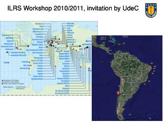
ILRS Network • 33 global stations providing tracking data regularly • Majority of SLR stations co-located with GNSS
Selected SLR Stations Around the World Zimmerwald, Switzerland Shanghai, China NGSLR, Greenbelt, MD USA Matera, Italy MLRS, TX USA Kashima, Japan Riyadh, Saudi Arabia TROS, China Wettzell, Germany Tahiti, French Polynesia TIGO, Concepcion, Chile Yarragadee, Australia Hartebeesthoek, South Africa
NASA SLR Systems NASA’s Next Generation SLR (NGSLR), GGAO, Greenbelt, MD
Sample of SLR Satellite Constellation(Geodetic Satellites) Etalon-I & -II LAGEOS-2 LAGEOS-1 Starlette Stella GFZ-1 Ajisai
Sample of SLR Satellite Constellation(POD Support) Terra-SAR-X CHAMP ERS-1 GFO-1 ERS-2 Meteor-3M Jason-1 Envisat GRACE ANDE
Sample of SLR Satellite Constellation(HEO) GLONASS GIOVE-A ETS-8 GPS
Example Satellite Configurations GRACE (courtesy of U. TX/CSR) TOPEX/Poseidon
Pass Interleaving Pass interleaving allows stations to track satellites that are simultaneously visible
2 kHz operation to increase data yield and improve interleaving Eye-safe operations and auto tracking Event timers with near-ps resolution Web based restricted tracking to protect optically vulnerable satellites (ICESat, ALOS, etc.) Two wavelength experiments to test refraction models Experiments continue to demonstrate optical transponders for interplanetary ranging Transponder experiment to Messenger (24.3 million km) was a two-way demonstration that resulted in a range precision of less than 20 cm. Mars Global Surveyor MOLA experiment (over 80 million km link) was a one-way demonstration due to an inoperative laser at Mars. Technology Developments
LAGEOS Pass from Graz Station High repetition rate, short pulse lasers allow us to see retroreflector array details
GNSS retroreflector activities Dialog underway with relevant agencies on the importance of including reflectors on GPS-III satellites Specification document for GNSS array created for Governing Board consideration Study underway at GSFC on hollow cube technology in collaboration with a newly-established testing facility (Laboratori Nazionali di Frascati, LNF, Italy) Several stations now ranging to ETS-8 in synchronous orbit Retroreflector Technology Single hollow cube Hollow cube array configuration
ILRS “official products” (station coordinates and EOP) issued weekly Seven ILRS Analysis Centers contribute to the official products: ASI, Agenzia Spaziale Italiana BKG, Bundesamt für Kartographie und Geodäsie DGFI, Deutsches Geodätisches Forschungsinstitut GA, Geosciences Australia GFZ, GeoForschungsZentrum Potsdam JCET, Joint Center for Earth Systems Technology NSGF, NERC Space Geodesy Facility Combination and Combination Back-up Centers at ASI and DGFI compute the combination products and furnish them to the IERS Time series of weekly solutions is provided to the IERS for the development of the ITRF (ITRF 2005) Analysis of early LAGEOS (1976-1993) data underway for ILRS product submission to the next reference frame New “official POD product” for geodetic satellites under development Analysis Activities
Geocenter Motion • mm-level Geodesy requires understanding of the reference frame and its distortions to acute levels of precision. • Shown here is the change in the origin of the crust-fixed frame w.r.t. the center of mass due to non tidal mass transport in the atmospheric and hydrospheric systems.
Solar System Science Solar Physics: gravity field, internal mass distribution and rotation Lunar ephemeredes and librations Planetary ephemeredes Mass distribution within the asteroid belt General Relativity Tests of relativity and constraints on its metrics Precession of Mercury’s perihelion Constraints on the magnitude of G-dot (1x10-12 from LLR) Gravitational and velocity effects on spacecraft clocks Shapiro Time Delay Lunar and Planetary Mission Operations Spacecraft ranging Calibration/validation/backup for DSN microwave tracking Subnanosecond transfer of GPS time to interplanetary spacecraft for improved synchronization of Earth/spacecraft operations Independent self-locking beacon for collocated laser communications systems (e.g., NASA’s Mars Laser Communications Demonstration) Some Transponder Applications
One-Way Earth-to-MarsTransponder Experiment(September 2005) 80 Million Km! ~500 laser pulses observed at Mars! GSFC 1.2 Meter Telescope Mars Orbiter Laser Altimeter (MOLA) Ground Station Xiaoli Sun Jan McGarry Tom Zagwodzki John Degnan Science/Analysis/Spacecraft David Smith Maria Zuber Greg Neumann Jim Abshire
Transmit 532nm laser pulses at 28 Hz to LRO Time stamp departure and arrival times LRO Laser Ranging Greenbelt, MD LRO Receiver telescope on High Gain Antenna System (HGAS) routes LR signal to LOLA LOLA channel 1 detects LR signal LR Receiver Telescope Fiber Optic Bundle
Gravity changes from SLR showinglong-wavelength water redistribution Large interannual variations related to strong El-Niño-Southern Oscilation (ENSO) events seasonal variation only From Cheng and Tapley (2004) Seasonal variation from mass redistribution in atmosphere, ocean and continental water
Multi-year gravity changes from SLR(seasonal variation removed) Cheng and Tapley (2004) Secular trend significantly affected if time series is not long enough Cox and Chao (2002)