Download
1 / 19
190 likes | 506 Vues
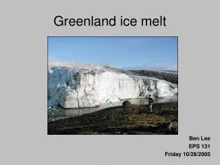
Sub-Glacial Topography and Ice Discharge of the Greenland Ice Sheet. Ms. Amber E. Smith – REU Student Mr. Eunmok Lee – GRA Dr. Kees van der Veen – Advisor. Introduction Bamber Map Flight Lines Definitions Greenland Sub-Glacial Topography Research Focus Method of Study Radar Images.

E N D
Sub-Glacial Topography and Ice Discharge of the Greenland Ice Sheet Ms. Amber E. Smith – REU Student Mr. Eunmok Lee – GRA Dr. Kees van der Veen – Advisor
Introduction Bamber Map Flight Lines Definitions Greenland Sub-Glacial Topography Research Focus Method of Study Radar Images Method of Study (cont.) Choosing Valleys Google Earth Image Balance Velocities Map Summary Future Work Discussion References Acknowledgements Outline
Introduction • Ice thickness data collected periodically since the 1970’s. • Jonathan Bamber developed a map of the sub-glacial topography of Greenland. (Bamber, 2001) • Narrow sub-glacial valleys are believed to affect the movement of the ice sheet. (Van der Veen and others, 2007)
Bamber Map • Created by Jonathan Bamber in 2001 • Shows the elevation of the bed topography of Greenland • Elevations calculated by subtracting the ice thickness grid from a DEM (Digital Elevation Model)
Flight Lines • The routes taken to obtain ice thickness data (radar images) by the University of Kansas (CReSIS) from 1993 until 2003.
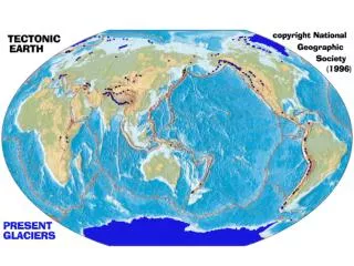
Definitions • Greenland: The largest island in the world, located between the North Atlantic and Arctic oceans • Sub-Glacial: Beneath a glacier • Glacier: An enormous mass of ice, formed by compacted snow, slowly flowing over land • Topography: Portrayal of the features and layout of land surfaces
Research Focus • Reanalyze the radar images and identify narrow sub-glacial trenches. • Determine if narrow valleys affect the movement of the ice sheet by comparing their locations with the balance velocities of the ice sheet.
Method of Study • Determined the location of Greenland’s sub-glacial valleys using radar data from 1993 until 2003. • Mapped the location of narrow sub-glacial valleys using Google Earth. • Compared location of valleys with the map of balance velocities.
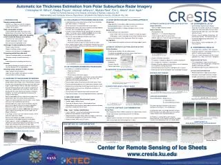
Radar Image • Example of original radar image • Ice sheet surface • Bed topography • Snow layers
Area in the orange rectangle Bed topography only Easier to read Refined Radar Image
Choosing Valleys • Wanted • Deeper valleys • Unwanted • Relatively flat
Google Earth Image • Shows the location of the narrow sub-glacial valleys • Color coded for each year data was collected
Location of Valleys vs. Map of Balance Velocities • Balance Velocities map • Map of the narrow valleys
Summary • Reanalyzed radar profiles to identify narrow sub-glacial trenches • Narrow valleys located along the edge of the ice sheet, mainly on the eastern side • Jakobshavn area, on the western coast, an exception
Future Work • Obtain local bed topography 2-D image • Smaller Area • Compare the new 2-D image with Bamber’s bed DEM and the balance velocities map • Narrow sub-glacial valleys seem to affect the movement of the ice sheet • Depend more on the depth of the valleys than the number of valleys • Determine the presence of water in the valleys
Discussion • MATLAB – find a way to keep the image from overlapping when the data has similar coordinates • Radar images – represent data in the same format • Give the scale for the horizontal axis • Keep the longitude and latitude units consistent
References • Bamber, J.L., S.P. Gogineni, R.L. Layberry. December 27, 2001. A New Ice Thickness and Bed Data Set for the Greenland Ice Sheet. Journal of Geophysical Research Vol 106, No. D24, Pages 33, 773-33, 780. • Glacier. Reference.com. Columbia Electronic Encyclopedia. Columbia University Press. http://www.reference.com/browse/columbia/glacier (accessed: July 05, 2007). • Greenland. Reference.com. Columbia Electronic Encyclopedia. Columbia University Press. http://www.reference.com/browse/columbia/Greenlan (accessed: July 03, 2007). • Greenland Data. The Center for Remote Sensing of Ice Sheets. Kansas University. http://www.cresis.ku.edu/research/data/greenland_data.html • Topography. Reference.com. Columbia Electronic Encyclopedia. Columbia University Press. http://www.reference.com/browse/columbia/topograp (accessed: July 03, 2007). • World Maps Online. http://worldmapsonline.com/outline_maps.html
Acknowledgements • Dr. Kees van der Veen • Mr. Eunmok Lee • Mr. Randy Justin • Mr. Eduardo Cabret • Mr. Jilu Li • Mr. Edil Sepulvedo • Mr. Michael Ziegler • CReSIS • National Science Foundation