Download
1 / 19
190 likes | 263 Vues
XOVWM User Impact Study Coastal Simulations. Contacts: Zorana.Jelenak@noaa.gov Paul.S.Chang@noaa.gov. QuikSCAT Follow-On Mission Options. In June 2007, NOAA asked JPL to conduct a study to provide the technical readiness, cost, and impact to NOAA of (1M investment):

E N D
XOVWM User Impact StudyCoastal Simulations Contacts: Zorana.Jelenak@noaa.gov Paul.S.Chang@noaa.gov
QuikSCAT Follow-On Mission Options In June 2007, NOAA asked JPL to conduct a study to provide the technical readiness, cost, and impact to NOAA of (1M investment): • A QuikSCAT equivalent re-flight • An Extended Ocean Vector Winds Mission (XOVWM) • A constellation (2) of XOVWM instruments • A draft of the final report documenting results of this study will be ready by January, 2008
XOWVM Impact Study • As part of JPL study user input is needed regarding proposed mission options • Input desired by 4th of January • Mini wind workshop held at the end of NOAA Hurricane conference and study results were presented • GoTo meetings are set up to reach as many interested users as possible • Written statements from offices are desired addressing the following questions: • What realized impacts on your daily work would be continued if QuikSCAT-like instrument is launched (swell forecast?, ) • Based on simulation results presented what is perceived impact that new capability can bring to your areas of responsibility (no buoys in particular areas of interest, wind events affecting your particular region not observed so far…) • Due to time limitations simulation study is limited in its scope. In order to get more comprehensive understanding of new capability what are simulations that would be of interest for your area of responsibilities
Target Level 1 Performance Requirements • Higher spatial resolution (~5km) • Full wind speed range (to category 5), • Coastal coverage 2.5-5 km of land • Significantly better retrievals in rain impacted measurements For NASA missions, these are must meet requirements which must be demonstrated prior to launch. NASA instruments frequently perform significantly better the requirements.
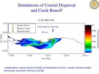
XOVWM Coastal Studies • Motivation • Nearly 50% of the US population lives near the coasts • Coastal fisheries depend on wind-driven nutrient upwelling • The shipping and fishing industries need to know winds near the coasts • Winds near the coasts are influenced by land topography and can exhibit strong jets and fronts • XOVWM can measure winds with 2.5km of the coast • QuikSCAT measures winds only up to 20 km from the coast, and cannot meet the coastal winds needs • Study description: • Use NOGAPS model wind complemented with SAR 500m resolution wind speed observations to simulate XOVWM and QuikSCAT data (SAR does not provide direction data and has limited temporal coverage.) • Primary data (Alaska) selected by NOAA based on known hazardous coastal winds in shipping lanes and fisheries • Additional data (California & Oregon) selected based on known highly variable coastal winds
Alaska Coast: Chatham Strait & Cross Sound Juneau Cross Sound The Alaska coast near Juneau and Sitka has frequent strong coastal winds which affect the safety of shipping and fishing boats. Sitka Chatham Strait
Alaska CoastCurrently Available Routine Data Availability Occasionally, SAR wind speed data (no directions) are available that give an indication of the true wind variability. Note speeds do not agree with model. Model winds are routinely available at low resolution, which fail to capture high speed coastal winds and variability
Gulf of Alaska Wind Retrieval Examples 58.5N Juneau Chatman Strait 55.5N 136W 133W XOVWM Retrievals SAR Winds + NOGAPS Directions QuikSCAT-like Retrievals
Gulf of Alaska Wind Retrieval Examples 60N 56.5N 154W 151W SAR Winds + NOGAPS Directions QuikSCAT-like Retrievals XOVWM Retrievals
West Coast Wind Example – 05/09/05 39.5N Pt Arena Pt Reyes San Francisco Bay 37.5N 124W 122.5W XOVWM Retrievals SAR Winds + NOGAPS Directions QuikSCAT-like Retrievals
West Coast Wind Example – 05/06/05 39.5N Pt Arena Pt Reyes San Francisco Bay 37.5N 124.5W 122.5W XOVWM Retrievals SAR Winds + NOGAPS Directions QuikSCAT-like Retrievals
08/23/05 – 18:25UTC XOVWM Retrievals SAR Winds + NOGAPS Directions QuikSCAT-like Retrievals
08/26/05 – 18:30UTC XOVWM Retrievals SAR Winds + NOGAPS Directions QuikSCAT-like Retrievals
09/08/05 – 06:10UTC XOVWM Retrievals SAR Winds + NOGAPS Directions QuikSCAT-like Retrievals
Written Feedback on Following Questions is Desired by 4th of Jan ‘08 • What realized impacts on your daily work would be continued if QuikSCAT-like instrument is launched (swell forecast?, ) • Based on simulation results presented what is perceived impact that new capability can bring to your areas of responsibility (no buoys in particular areas of interest, wind events affecting your particular region not observed so far…) • Due to time limitations simulation study is limited in its scope. In order to get more comprehensive understanding of new capability what are simulations that would be of interest for your area of responsibilities Additional information available at: http://manati.orbit.nesdis.noaa.gov/SVW_nextgen/osvw_mini_workshop.html