Download
1 / 23
230 likes | 234 Vues
This data set provides a low resolution nature run from May 2005 to June 2006, with two high resolution periods during the hurricane season and convective precipitation over CONUS. The data is available from ECMWF, NCEP, ESRL, and NASA/GSFC.

E N D
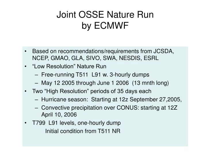
Joint OSSE Nature Runby ECMWF • Based on recommendations/requirements from JCSDA, NCEP, GMAO, GLA, SIVO, SWA, NESDIS, ESRL • “Low Resolution” Nature Run • Free-running T511 L91 w. 3-hourly dumps • May 12 2005 through June 1 2006 (13 mnth long) • Two “High Resolution” periods of 35 days each • Hurricane season: Starting at 12z September 27,2005, • Convective precipitation over CONUS: starting at 12Z April 10, 2006 • T799 L91 levels, one-hourly dump Initial condition from T511 NR
Archive and Distribution The Complete data set • saved at ECMWF, NCEP, ESRL, and NASA/GSFC • ECMWF: • Archived in the MARS system as expver=etwu • NASA/GSFC portal: • ID and password required • contact: Harper Prior (Harper.Pryor@nasa.gov) • Gradsdods access is available for T511 NR. The data can be down loaded in grib1, NetCDF, binary. The data can be retrieved globally or selected region. • Provide IP number to :Arlindo da Silva (Arlindo.Dasilva@nasa.gov) • NCEP: Require account at NCEP • Nature Runs are available to designated users for research purpose& users known to ECMWF • The user list outside of the EC is maintained by :Michiko Masutani (michiko.masutani@noaa.gov) and reported to ECMWF
Archive and Distribution Supplemental data Supplemental low resolution regular lat lon data 1degx1deg for T511 NR, 0.5degx0.5deg for T799 NR Pressure level data: 31 levels, Potential temperature level data: 315,330,350,370,530K Selected surface data for T511 NR: Convective precip, Large scale precip, MSLP,T2m,TD2m, U10,V10, HCC, LCC, MCC, TCC, Sfc Skin Temp Complete surface data for T799 NR Available from NCAR CISL Research Data Archive. Data set ID ds621.0 Currently NCAR account is required for access. (Also available from NCEP hpss, NASA/GSFC Portal, ESRL, NCAR/MMM, NRL/MRY, JMA, MSU, Utah) Note: This data must not be used for commercial purposes and re-distribution rights are not given.
Squall line / cold front case event from T799 NR Mississippi State University Hill_MSU_case_event_T799_080731.ppt
An Observing System Simulation Experiment to Evaluate ATMS and CrIS Observations Christopher M. Hill Patrick J. Fitzpatrick Valentine G. Anantharaj Mississippi State University Lars-Peter Riishojgaard/NASA T799 NR case event May 3 06 UTC MSU Out of season storm over Mississippi. Provide good sample for MSU.
Evaluation of Tropics in T511 Oreste Reale Reale_Evaluation_ECMWF_T511NR.ppt • The NR shows a stronger than climatology TEJ, but a very credible and realistic decrease of easterly speed with the progress of the monsoon season. As a consequence, the environment becomes conducive to more development • First Nature Run to simulate one entire season • Twelve tropical cyclones develop • Realistic variability of tracks • Most intense reaches 957 hPa • Binary vortices, looping and singularities are observed (good from OSSE perspective)
Concluding remarks on the African Monson region and tropical Atlantic (T511NR) • A synoptic assessment of the NR over the AM region and the tropical Atlantic shows an overall very realistic African Monsoon, AEJ and wave activity • Several weak tropical and sub-tropical systems are present, together with `major’ tropical cyclones • In spite of a tendency of creating several early recurvers, it can be stated that the NR, given the resolution limitation, does have a very good representativeness of tropical cyclone track variability in the Atlantic, as it would occur in an active season • This Nature Run represents a very promising tool to perform OSSEs over the tropical Atlantic
Summary of Tropics of T799 NROreste Reale Reale_T799_October_Nature_Run.ppt • AEJ is 40% weaker than climatology • Atlantic TC activity contains some highly suspicious tracks • Eastern Pacific seems to present excessive proliferation of weak TCs • The intensity of the strongest ATL systems is not superior to T511 • Different behavior in different basins • Structure of some intense system not very satisfactory in terms of scale and size of eye-like feature
Preliminary conclusions • The increased resolution does not necessarily provide stronger confidence in a much better Nature Run for the tropics • Representation of TC activity does not immediately appear superior to the T511 • Caution should perhaps be used in adopting this NR for applications centered on future instruments targeting hurricanes • Further investigation is needed
Summary: Extratropical Cyclones 31R1 @ T511 (DJFM) Thomas Jung Jung_ECMWF_Nature_Run_TJ.ppt • Synoptic activity (extratropics): • Generally well represented • Distribution of storm frequency quite realistic • Problems in the Gulf Stream/Kurushio area? • Too many systems in the eastern Atlantic (blocking)
Summary: Tropical Cyclones 31R1 @ T511 (DJFM) • T511 model produces quite realistic frequency of occurrence of TS/Hurricanes in the Atlantic. • North African Monsoon too strong + northward shifted. • AEJ is too weak (problem at higher resolution). • Perhaps slightly too much AEW activity. • Strong problems in the western tropical Pacific (too little atmospheric upwelling). Problem larger at higher resolution.
Some Other Issues: Model Climate 31R1 @ T511 • Amplitude of the MJO is underestimated (better in recent cycles but still an issue). • Convectively coupled Kelvin waves in the tropics are underestimated (better from 32R3 onwards). • Too little (much) precipitation over the tropical continents (oceans) (improved in recent cycles). • No QBO • Euro-Atlantic blocking significantly underestimated (large improvements in 33R1). • Anti-cyclonic circulation bias in the North Pacific (fixed in 32R3)
Tropical Cyclones in Recent Model Cycles • Generally there is an increase in the number/intensity of tropical cyclones/hurricanes. • Particularly lower resolution versions perform better than older cycles (e.g., US landfall). • Large increases in the western tropical Pacific (partly due changes in the large-scale atmospheric circulation). Too large?
Sensitivity to Horizontal ResolutionThomas JungJung_ECMWF_Nature_Run_TJ.ppt • Short-range and medium-range forecasts suggest that T799, if anything, produces stronger hurricanes than T511. • Resolution studies, however, suggests, that some aspects of the tropical climate (i.e., beyond the medium-range) of 31R1 deteriorate when increasing horizontal resolution (T159->T511). So it may be possible that T799 performs worse than T511. • In the extratropics the largest changes occur when going from T95 to T159. Rather little changes occur beyond T159 (T159->T511). Hence, it seems reasonable to assume that T511 and T799 perform similar.
Colder surface in Both poles (T799NR) Michiko Masutani Masutani_T799_T511.080410.ppt Transient eddy kinetic energy become activs in SH toward summer Both Poles are colder in T799 NR 10 day average sfc skin temperature
Zonal mean high pass eddy KE at 250hPa Three day running mean subtracted Interpolated to 1degree 3 hour sampling Toward end of October, SH become erroneously active in T799 NR.
Arctic in T511 NRNikki Prive 2008//Jan-Mar08/Prive_arctic_ice_080221.ppt • Stratospheric ‘cold pole’ - without input from obs, model develops abnormally cold polar region in winter with strong polar vortex. Common problem with global models. • Surface temperatures are strangely high over the arctic • Disconnect with temperatures above surface layer? • Low level inversion too weak - impacted by many processes • What is energy balance over ice? SHF/LHF/longwave/cloud impacts? • Sea ice and SST are applied from 2005/6 fields, not interactive with model atmosphere
Omega fields in Hurricane (T511 NR) Nikki Prive A mage from the storm that hits Florida, with the 850 mb omega in full colors (blue = up), and the 250 mb omega in red contours (solid lines = up) The upper level upward maximum seems to wobble around, displaced about one degree from the lower level area of strong vertical velocities. It doesn't really look like an artifact of the low resolution interpolation. I would have expected stronger stacking of the omega field - maybe this is not a problem, though? I haven't looked at the full reduced gaussian data yet because it is messy, and I'm certainly not any kind of expert on hurricanes....
Quick look using 1degree data Min MSLP T799 OCT05 period T511 T799 By Michiko Masutani
Quick look using 1degree data Convective Precipitation 3 hour mean 12z-15Z Oct05 2005 T511 T799 By Michiko Masutani
Quick look using 1degree data Min MSLP T799 APR06 period T511 T799 By Michiko Masutani
Convective Precipitation in Spring Quick look using 3 hour mean 1degree data T511 06Z Apr 25, 2006 T799 01Z May 2, 2005 By Michiko Masutani
Plot by Yoshiaki Sato Quick satellite view datTB(ix,iy)=datTB(ix,iy)*(1.0-datC(ix,iy,iz))+datT(ix,iy,iz)*datC(ix,iy,iz) # datC: CC, datT: T IR T799 NR 2006041106