Download
1 / 1
10 likes | 119 Vues
USING A GEOGRAPHIC INFORMATION SYSTEM (GIS) TO MODEL SLOPE INSTABILITY AND DEBRIS FLOW HAZARDS IN THE FRENCH BROAD RIVER WATERSHED, NORTH CAROLINA Anne Carter Witt Dept. of Marine, Earth and Atmospheric Sciences, Box 8208, North Carolina State University, Raleigh, N. C. 27695, awitt48662@aol.com.

E N D
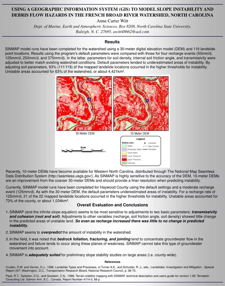
USING A GEOGRAPHIC INFORMATION SYSTEM (GIS) TO MODEL SLOPE INSTABILITY AND DEBRIS FLOW HAZARDS IN THE FRENCH BROAD RIVER WATERSHED, NORTH CAROLINAAnne Carter WittDept. of Marine, Earth and Atmospheric Sciences, Box 8208, North Carolina State University, Raleigh, N. C. 27695, awitt48662@aol.com Results SINMAP model runs have been completed for the watershed using a 30-meter digital elevation model (DEM) and 119 landslide point locations. Results using the program’s default parameters were compared with those for four recharge events (50mm/d, 125mm/d, 250mm/d, and 375mm/d). In the latter,parameters for soil density, internal soil friction angle, and transmissivity were adjusted to better match existing watershed conditions. Default parameters tended to underestimated areas of instability. By adjusting soil parameters, 93% (111/119) of the mapped landslide locations occurred in the higher thresholds for instability. Unstable areas accounted for 63% of the watershed, or about 4,421km². Recently, 10-meter DEMs have become available for Western North Carolina, distributed through The National Map Seamless Data Distribution System (http://seamless.usgs.gov/). As SINMAP is highly sensitive to the accuracy of the DEM, 10-meter DEMs are an improvement from the coarser 30-meter DEMs and should provide a finer resolution when predicting instability. Currently, SINMAP model runs have been completed for Haywood County using the default settings and a moderate recharge event (125mm/d). As with the 30-meter DEM, the default parameters underestimated areas of instability. For a recharge rate of 125mm/d, 21 of the 22 mapped landslide locations occurred in the higher thresholds for instability. Unstable areas accounted for 73% of the county, or about 1,034km². • Overall Evaluation and Conclusions • SINMAP (and the infinite slope equation) seems to be most sensitive to adjustments to two basic parameters: transmissivity and cohesion (root and soil). Adjustments to other variables (recharge, soil friction angle, soil density) showed little change in the predicted areas of unstable land. So even as recharge increased there was little to no change in predicted instability. • SINMAP seems to overpredict the amount of instability in the watershed. • In the field, it was noted that bedrock foliation, fracturing, and jointing tend to concentrate groundwater flow in the watershed and failure tends to occur along these planes of weakness. SINMAP cannot take this type of groundwater movement into account. • SINMAP is adequately suited for preliminary slope stability studies on large areas (i.e. county-wide). References Cruden, D.M. and Varnes, D.J., 1996, Landslide Types and Processes, in Turner A.K., and Schuster, R. J., eds., Landslides: Investigation and Mitigation - Special Report 247: Washington, D.C., Transportation Research Board, National Research Council, p. 36-75. Pack, R.T., Tarboton, D.G., and Goodwin, C.N., 1998, Terrain stability mapping with SINMAP, technical description and users guide for version 1.00: Terratech Consulting Ltd. Salmon Arm, B.C., Canada, Report Number 4114-0, 68 p.