Download
1 / 47
470 likes | 475 Vues
Chapter 19. Air Pressure and Wind. Air Pressure Defined. 19.1 Understanding Air Pressure. Air pressure is the pressure exerted by the weight of air.

E N D
Chapter19 Air Pressure and Wind
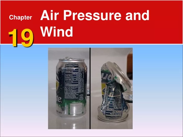
Air Pressure Defined 19.1 Understanding Air Pressure Air pressure is the pressure exerted by the weight of air. • Air pressure is exerted in all directions— down, up, and sideways. The air pressure pushing down on an object exactly balances the air pressure pushing up on the object. • Watch this can crushing example of air pressure. air pressure is a monster
Measuring Air Pressure 19.1 Understanding Air Pressure A barometer is a device used for measuring air pressure. • When air pressure increases, the mercury in the tube rises. When air pressure decreases, so does the height of the mercury column. • This guy can show you how a barometer works and has a cool voice.
Factors Affecting Wind 19.1 Understanding Air Pressure • Wind is the result of horizontal differences in air pressure. Air flows from areas of higher pressure to areas of lower pressure. The unequal heating of Earth’s surface generates pressure differences. Solar radiation is the ultimate energy source for most wind. Three factors combine to control wind: pressure differences, the Coriolis effect, and friction.
Factors Affecting Wind 19.1 Understanding Air Pressure Pressure Differences • A pressure gradient is the amount of pressure change occurring over a given distance. • Closely spaced isobars—lines on a map that connect places of equal air pressure—indicate a steep pressure gradient and high winds. Widely spaced isobars indicate a weak pressure gradient and light winds.
Isobars Copy the activity on the following page into paint. Read the info and complete the activities.
Factors Affecting Wind 19.1 Understanding Air Pressure Coriolis Effect • The Coriolis effect describes how Earth’s rotation affects moving objects. In the Northern Hemisphere, all free-moving objects or fluids, including the wind, are deflected to the right of their path of motion. In the Southern Hemisphere, they are deflected to the left. • The coriolis effect can be a difficult concept to understand. To get more information about the coriolis effect, click on the link below. • Understand the Coriolis Effect • Video demonstrating result of Coriolis Effect
The Coriolis Effect Use the cards, scissors, markers, etc. at your lab station. Follow Dr. C as he helps you understand Coriolis Effect.
Factors Affecting Wind 19.1 Understanding Air Pressure Friction • Friction acts to slow air movement, which changes wind direction. • Jet streams are fast-moving rivers of air that travel between 120 and 240 kilometers per hour in a west-to-east direction. How do Jet Streams Work??? More about jet streams Even more about jet streams in the United States
Highs and Lows 19.2 Pressure Centers and Winds Cyclones are centers of low pressure. Anticyclones are centers of high pressure. In cyclones, the pressure decreases from the outer isobars toward the center. In anticyclones, just the opposite is the case—the values of the isobars increase from the outside toward the center.
Highs and Lows 19.2 Pressure Centers and Winds Cyclonic and Anticyclonic Winds • When the pressure gradient and the Coriolis effect are applied to pressure centers in the Northern Hemisphere, winds blow counterclockwise around a low. Around a high, they blow clockwise. • In either hemisphere, friction causes a net flow of air inward around a cyclone and a net flow of air outward around an anticyclone.
Highs and Lows 19.2 Pressure Centers and Winds Weather and Air Pressure • Rising air is associated with cloud formation and precipitation, whereas sinking air produces clear skies. Weather Forecasting • Weather reports emphasize the locations and possible paths of cyclones and anticyclones. • Low-pressure centers can produce bad weather in any season.
Airflow Patterns, Surface and Aloft LOW = Convergence HIGH = Divergence • Lows move west to east. • Their paths can be somewhat unpredictable, making accurate estimation of their movement difficult. • It is important to understand total atmosphere circulation….
Global Winds 19.2 Pressure Centers and Winds The atmosphere balances these differences by acting as a giant heat-transfer system. This system moves warm air toward high latitudes and cool air toward the equator. Non-Rotating Earth Model • On a hypothetical non-rotating planet with a smooth surface of either all land or all water, two large thermally produced cells would form.
Circulation on a Non-Rotating Earth • Heated air at the equator would rise until it reached the Tropopause. • Eventually the upper-level airflow would reach the poles, sink, spread out in all directions at the surface, and move back toward the equator.
Global Winds 19.2 Pressure Centers and Winds Rotating Earth Model • If the effect of rotation were added to the global circulation model, the two-cell convection system would break down into smaller cells. • Near the equator, rising air produces a pressure Zone known as the equatorial low – a region characterized by abundant precipitation. • 20-30 degrees, north or south latitude, the sinking air and its associated heating due to compression produce hot, arid conditions – the center of this zone of sinking dry air is the subtropical high.
• Trade winds are two belts of winds that blow almost constantly from easterly directions and are located on the north and south sides of the subtropical highs. • Westerlies are the dominant west-to-east motion of the atmosphere that characterizes the regions on the poleward side of the subtropical highs. • Polar easterlies are winds that blow from the polar high toward the subpolar low. These winds are not constant like the trade winds. • A polar front is a stormy frontal zone separating cold air masses of polar origin from warm air masses of tropical origin.
Circulation on a Rotating Earth global air circulation
Global Winds 19.2 Pressure Centers and Winds Influence of Continents • The only truly continuous pressure belt is the subpolar low in the Southern Hemisphere. In the Northern Hemisphere, where land masses break up the ocean surface, large seasonal temperature differences disrupt the pressure pattern. • Monsoons are the seasonal reversal of wind direction associated with large continents, especially Asia. In winter, the wind blows from land to sea. In summer, the wind blows from sea to land.
Surface Pressure The Intertropical Convergence Zone (ITCZ) is a zone of unstable air that forms along the equator where the northeast and southeast trade winds converge.
What are centers of low pressure called? • Air masses • Anticyclones • Cyclones • Jet streams
Variations in air pressure from place to place are the principal caused of • clouds. • Lows. • Hail. • Wind.
In the winter, large landmasses often develop a seasonal • high-pressure system • Low-pressure system • Typhoon • Trade wind
What is the pressure zone that is associated with rising air near the equator? • Equatorial low • Equatorial high • Subtropical low • Subtropical high
In what stormy region do the westerlies and polar easterlies converge? • Equatorial low • Subpolar high • Polar front • Subtropical high
Local Winds 19.3 Regional Wind Systems The local winds are caused either by topographic effects or by variations in surface composition—land and water—in the immediate area. Land and Sea Breezes • In coastal areas during the warm summer months, the land surface is heated more intensely during the daylight hours than an adjacent body of water is heated. As a result, the air above the land surface heats, expands, and rises, creating an area of lower pressure. At night the reverse takes place.
Local Winds 19.3 Regional Wind Systems Valley and Mountain Breezes • In mountainous regions during daylight hours, the air along the slopes of the mountains is heated more intensely than the air at the same elevation over the valley floor. Because this warmer air on the mountain slopes is less dense, it glides up along the slope and generates a valley breeze. After sunset the pattern may reverse.
How Wind Is Measured 19.3 Regional Wind Systems Wind Direction • The prevailing wind is the wind that blows more often from one direction than from any other. • In the United States, the westerlies consistently move weather from west to east across the continent.
How Wind Is Measured 19.3 Regional Wind Systems Wind Speed • An anemometer is an instrument that resembles a cup and is commonly used to measure wind speed.
El Niño and La Niña 19.3 Regional Wind Systems El Niño • El Niño is the name given to the periodic warming of the ocean that occurs in the central and eastern Pacific. • At irregular intervals of three to seven years, these warm countercurrents become unusually strong and replace normally cold offshore waters with warm equatorial waters. • A major El Niño episode can cause extreme weather in many parts of the world.
El Niño and La Niña 19.3 Regional Wind Systems La Niña • Researchers have come to recognize that when surface temperatures in the eastern Pacific are colder than average, a La Niña event is triggered that has a distinctive set of weather patterns.
Global Distribution of Precipitation 19.3 Regional Wind Systems Global precipitation can be explained if knowledge of global winds and pressure systems are applied.
Valley and mountain breezes are examples of ____. • global winds • trade winds • local winds • jet streams
A sea breeze usually originates during the ____. a. evening and flows toward the land • day and flows toward the land • evening and flows toward water • day and flows toward the water
A land breeze usually originates during the ____. a. evening and flows toward the land • day and flows toward the land • evening and flows toward the water d. day and flows toward the water
A wind that consistently blows more often from one direction than from any other is called a ____. a. local wind • prevailing wind • trade wind • jet stream
Winds are labeled according to which of the following? • whether they originate on land or water • the direction from which they blow • the region in which they can be found • none of the above
Which phenomenon is associated with surface temperatures in the eastern Pacific that are colder than average? a. La Niña • El Niño • global warming • local winds
Which of the following is a warm countercurrent that periodically flows southward along the coasts of Ecuador and Peru? a. mountainbreeze • La Niña • El Niño d. none of the above