Download
1 / 12
120 likes | 222 Vues
Will a Great Quake Strike Cascadia? Earthquake Group EarthScope Cascadia workshop August 4, 2006. Team members. List team members and respective roles. Michael Hubenthal – Group Facilitator John Taber – IRIS Data Provider Jenda Johnson – IRIS Tools Consultant Joshua Arnold – Teacher

E N D
Will a Great Quake Strike Cascadia? Earthquake Group EarthScope Cascadia workshop August 4, 2006
Team members • List team members and respective roles. Michael Hubenthal – Group Facilitator John Taber – IRIS Data Provider Jenda Johnson – IRIS Tools Consultant Joshua Arnold – Teacher Adrienne Ash – Teacher Pennie Edmond - Teacher LuAnn Dahlman – TERC Curriculum Development Ken Creager – UW Scientist Meghan Miller – CWU Scientist
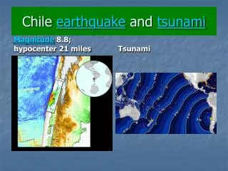
The storyline • --The Hook • If you knew that an earthquake and tsunami like those in Sumatra were going to strike, what would you do? How would you prepare? • --In a nutshell • Do you think that these could happen in America? • Where in the world do great earthquakes happen? • Seismic/Eruption (or on paper) • Look for Mw>=8 on map • Hand out partially complete table • Gather data to complete the sample table • What relationships do you see in the data? • Mostly on subduction zones, especially if > 8.5.
The storyline • --In a nutshell (con’t) • How might we plot these events? • When scientists asked themselves this question in the 1980’s they chose to make a plot of the age of the oceanic crust against convergence rate. • Try age of the oceanic crust against convergence rate • Draw a line with all earthquakes Mw=9 or larger on one side. It’s okay if there are smaller earthquake with the 9s. • Draw another line with all the 8s or larger on one side. • Draw another line with all the 7s or larger on one side. • What relationships do you see in the plot? • Does the U.S. have any subduction zones? If so, where are they? • Let’s put Cascadia on this plot and see what size of earthquake it might produce…..
The storyline • --In a nutshell (con’t) • What do you think? • Scientists published this plot in 1980 (Ruff and Kanamori, 1980) and added Cascadia to ask whether it could generate a great earthquake (Heaton and Kanamori, 1984). They concluded a great earthquake was possible here. • This led other scientists to look for other kinds of evidence for a history of great earthquakes in the Pacific Northwest.
The storyline • Optional Step • Use SeismicEruption to compare and contrast 2-3 global subduction zones, including Cascadia, note absence of large shallow earthquakes in Cascadia • Bringing it home • In this part, students research the expert’s recommendations of how to prepare for an earthquake. • They end with a letter to their parents with a plan for their home. • If the parent signs the letter, they get extra credit, creating false expectations of their geology professor in college.
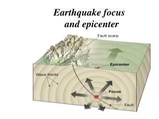
Using EarthScope Data • Types of Data Used: • Earthquake location, magnitude and damage caused • Plate movement rate and age (from Heaton/Kanamori Figure) • World map with plate boundaries
Using EarthScope Data Students will compile data on historical earthquakes: • Year • Place name • Magnitude • Age (Ma) • Plate motion (cm/yr) • Human casualties • Cost of Damage (dollars) • Other notes
Using EarthScope Data Software / URL’s used • Seismic Eruption http://www.geol.binghamton.edu/faculty/jones/jones.html#Seismic-Eruptions • Historic Worldwide Earthquakes – http://earthquake.usgs.gov/regional/world/historical.php • Lists of event data (date, location, depth, magnitude) http://neic.usgs.gov/neis/epic/epic.html
Using EarthScope Data Primary Study Area – Cascadia Secondary Study Areas – Sites where 8.0 or greater magnitude quakes have occurred globally.
What’s next? --If you had more work time, how would you proceed? • Develop list of guiding questions for each step of the investigation. • Coordinate with tsunami group to tie together both investigations.