Download
1 / 4
40 likes | 105 Vues
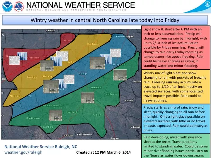
A low pressure system will move from the Gulf of Mexico and along the Carolina coast late Thursday through Friday. . Wintry weather in central North Carolina late today into Friday.

E N D
A low pressure system will move from the Gulf of Mexico and along the Carolina coast late Thursday through Friday. Wintry weather in central North Carolina late today into Friday Light snow & sleet after 6 PM with an inch or less accumulation. Precip will change to freezing rain by midnight, with up to 2/10 inch of ice accumulation possible by Friday morning. Precip will change to rain early Friday morning as temperatures rise above freezing. Rain could be heavy at times resulting in standing water and minor flooding. Wintry mix of light sleet and snow changing to rain with pockets of freezing rain. Freezing rain may accumulate a trace up to 1/10 of an inch, mostly on elevated surfaces, with some localized travel impacts possible. Rain could be heavy at times. Precip starts as a mix of rain, snow and sleet, quickly changing to all rain before midnight. Only a light glaze possible on elevated surfaces with little or no travel impactsexpected. Rain could be heavy at times. Rain developing, mixed with nuisance sleet at the onset. Travel problems limited to standing water. Could be some minor river flooding issues particularly on the Neuse as water flows downstream. National Weather Service Raleigh, NCweather.gov/raleigh Created at 12 PM March 6, 2014
A low pressure system will move from the Gulf of Mexico and along the Carolina coast late Thursday through Friday. Wintry weather in central North Carolina late today into Friday What the radar may look like at 7 PM. Precipitation spreading across most of the Piedmont, including the Triad and Triangle. Temperatures should still be above freezing in most places, though getting close to freezing in the northwest Piedmont after precipitation begins. What the radar may look like at 4 PM. Precipitation just moving into the state from the south. Temperatures should be well above freezing. National Weather Service Raleigh, NCweather.gov/raleigh Created at 12 PM March 6, 2014
A low pressure system will move from the Gulf of Mexico and along the Carolina coast late Thursday through Friday. Alternatives Possible for more snow and sleet before transition to freezing rain. Then, glazing could be a little higher. This is especially true the farther northwest one goes, to include Forsyth County. As freezing rain and rain develop, there could be urban, creek and small stream flooding concerns late tonight into Friday. Possible for a little more glazing in the northwest side of this area, but still should be mostly on elevated surfaces. Precip starts as a mix of rain, snow and sleet, quickly changing to all rain before midnight. Only a light glaze possible on elevated surfaces with little or no travel impactsexpected. Rain could be heavy at times. – higher confidence Rain developing, mixed with some nuisance sleet at the onset. Travel problems limited to standing water. Could be some minor river flooding issues particularly on the Neuse as water flows downstream. – higher confidence National Weather Service Raleigh, NCweather.gov/raleigh Created at 12 PM March 6, 2014
A low pressure system will move from the Gulf of Mexico and along the Carolina coast late Thursday through Friday. Impacts Power outages and downed tree limbs, more as glazing increases or is more than forecast due to precipitation and breezy conditions. Travel conditions difficult on untreated surfaces where temperatures are below freezing. Standing water later continuing to cause travel concerns. Isolated power outages and downed tree limbs due to precipitation and breezy conditions. Localized difficult travel conditions possible on untreated surfaces. Standing water later producing some travel concerns. Possible minor river flooding on the Haw. Very isolated power outages and downed limbs due to any glazing and breezy conditions. Standing water later producing some travel concerns. Mainstem creeks and streams running higher. Could be minor flooding on Fishing Creek. Travel problems should be limited to standing water. Minor river flooding issues particularly on the Neuse as water flows downstream over the next couple of days. National Weather Service Raleigh, NCweather.gov/raleigh Created at 12 PM March 6, 2014