Download
1 / 29
300 likes | 433 Vues
Europe, education and open geodata. Education and Culture Working Group Council of Europe, Strasbourg: 22 January 2013. Digital Agenda (https:// ec.europa.eu /digital-agenda/). Digital Agenda target areas (https:// ec.europa.eu /digital-agenda/ ). Pillar I: Digital Single Market

E N D
Europe, education and open geodata Education and Culture Working Group Council of Europe, Strasbourg: 22 January 2013
Digital Agenda target areas (https://ec.europa.eu/digital-agenda/) • Pillar I: Digital Single Market • Pillar II: Interoperability & Standards • Pillar III: Trust & Security • Pillar IV: Fast and ultra-fast Internet access • Pillar V: Research and innovation • Pillar VI: Enhancing digital literacy, skills and inclusion • Pillar VII: ICT-enabled benefits for EU society DG Education and Culture “New skills, New jobs” initiative
European Commission research Capacity for change: sustainable implementation and progressive scaling up (of ICT-enabled innovative learning environments) EC Joint Research Centre (2012) Europe needs to scale up its educational uses of ICT
Creative classrooms JRC (2012) "Challenges of implementing Creative Classrooms practices”, http://is.jrc.ec.europa.eu/pages/EAP/documents/_6_Etwinning_WS1_March2012.pdf, eTwinning conference, Tampere Finland
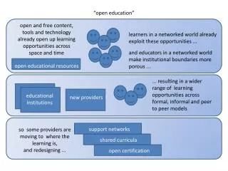
Open data • Sharing geographic data across borders is a key European policy: • collaboratively manage resources, • create fairer (transparent) governance structures and • contribute to each others' economic prosperity. Report on the potential of mapping software to empower consumers http://t.co/L25kIxlT
INSPIRE Directive • INSPIRE - Infrastructure for Spatial Information in Europe - an EU Directive • European governments work together to design common legislative standards that will allow, or oblige, national agencies to co-operate • Aim to create a common frameworkfor European spatial data • Now free data access across Europe – many countries still slow to develop this Europe OpenGeoData platform http://epsiplatform.eu/content/open-geodata
Open data – recent news • 12th December 2011 - Mrs Kroes, Commissioner for the Digital Agenda announced a new Open Data Strategy for Europe, she said: “The best way to get value from data is to give it away.” “Instead of needing complicated authorisation you will be automatically allowed to reuse the public data you need.” “Fees will be limited to marginal cost.” “I also say to private business – open your data”
Open data • Should provide political and economic decision-takers and scientists with reliable data for assessing environmental conditions across the whole of Europe • UK - http://data.gov.uk/ • IT - http://www.dati.piemonte.it • FR - http://opendata.paris.fr,http://www.data.gouv.fr/ • Dutch government released core data sets to the public free of charge for re-use, from January 1st 2012 NL - http://www.data.overheid.nl • Finnish government opened up all its data for free re-use from May 1st 2012 • Other countries? Regions?
Open data – recent news • Sept 12, 2012 - NeelieKroes speech • European Commission’s ongoing commitment to policies, projects and funding to support open data and open access – 4 features: 1. EU proposed new legislation to open up public sector information • Businesses and citizens can access and use this resource • The scope also includes cultural institutions • EC putting its own data on a single online portal, with free and easy access • could generate economic gains around €40 billion a year
Open data headlines 2. developments in cultural open data • EU promotes Europeana as the access point for Europe’s libraries, museums, galleries and archives • metadata for over 20 million exhibits in the public domain Europeana http://www.europeana.eu
Europeanahttp://www.europeana.eu Europeana http://www.europeana.eu
Open data headlines 3. Open collaborative science • Propose to make available, under open access, all publications that stem from EU-funded research • Open access to the data from scientific experiments and studies 4. support research related to open data • €45 million for open access infrastructures for science
EPSI Opendata Platform http://epsiplatform.eu/content/open-geodata
European dimension • European societal challenges • CORINE (Coordination of Information on the Environment) project • ‘Global Monitoring for Environment and Security' (GMES) – 2004 • INSPIRE Directive - 2007 • Open governance– new opportunities for citizens to interact • Open data – freedom of information (NeelieKroes, 2011; 2012) • Europe 2020 - Education & Training 2020 What about education? The need for geographic information is transforming Europe
No defined geospatial workforce Estimated 50,000 jobs in the geospatial industry cannot be filled in Europe. Industry growth at 7-10% per annum Little or no research on the geospatial workforce in Europe– a few countries starting to react (Belgium, Estonia, Finland) USA data: http://www.onetonline.org/find/quick?s=geospatial
Needs Analysis: Main issues • Infrastructureissues: soft- hardware, data • Low knowledge of teachers, low confidence • No timein the curriculum, curriculum too full • Not in teacher trainingcurriculum • Decision makers unaware of importance • No guidelineswhat students should be able to do • (Needs Analysis, digital-earth.eu Project, 2011) Not many teachers involved Too few young people with the necessary awareness, skills, knowledge and experience
Pilot project “Integrating DE” 1. Support education and training • continuity for digital-earth products 2. Research – Think Tank • White Paper/Book • Report on innovative pilots • Produce a ‘high growth industry’ profile • Develop indicators on geospatial status 3. Establish an expert group • Advise EC and bring agencies together 4. Launch event (Digital Earth summit) • industry meets education meets policy makers
Geo-services http://tinyurl.com/c2avu7h
Now ArcGIS Online et al. • Each producer creates maps and publishes services and metadata when they want • Can publish and reference own maps and services in their blog, web site, social networking • Can re-use one another’s available layers, including backgrounds / base maps
Conclusion … from LinkedIn Nov 2012 • “It’s fine to have geo-data, metadata, technology, top-class methods. But are all the considered people ready to use it really?” • Specific geoinformation knowledge is important …. geointelligence, geo-thinking… • quality and qualification of Human Resources will determine its use …. • any tool is better maintained, and utilizable, when its user is well trained…. • Should we not focus more on education and edification while developing the wider SDI concept?…. JiriHiess, LinkedIn, 12/11/2012
Conclusions • Strong EU commitment • Driven by the Digital Agenda for Europe • Little or no focus on education • Infrastructure increasingly in place • EU data coming online – EEA- EyeonEarth • Market-driven initiatives (Cloud)