Download
1 / 12
120 likes | 767 Vues
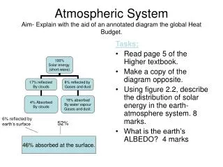
Aim- to describe and explain the formation of a variety of river features with the aid of annotated diagrams. River Velocity The THALWEG of the stream channel is the maximum velocity that weaves from side to side wriggling like a snake down the

E N D
Aim- to describe and explain the formation of a variety of river features with the aid of annotated diagrams • River Velocity The THALWEG of the stream channel is the maximum velocity that weaves from side to side wriggling like a snake down the channel as it is deflected from one bank to another. • In straight channels, riffles tend to develop at regular intervals. These typically slope alternately towards one bank and then another, and the thalweg winds between them. • Between the riffles occurs deeper pools. The spacing of these features is associated with the channel width, and usually the space between on riffle and the next is five to seven times the channel width.
Aim- to describe and explain the formation of a variety of river features with the aid of annotated diagrams • Sediment Transportation One of the most important relief forming activities of streamflow is its movement of broken rock debris and dissolved matter the Stream Load. This is governed by two factors; • Its energy • Amount of rock available A stream can wear away the bottom and sides of a rock channel, but to do so it must carry rock fragments. • Sediment already deposited • Mass movement downslope Different amounts and sizes of fragments occur in a stream at different points along the course of a river. • Where steep slopes are close to the channel (upper course) large blocks and boulders may fall in of rocks are well jointed or weathered. • Flat floodplain (lower course) the stream has available only the materials that carried out and deposited itself. Total Stream Load is composed of; • Solute • Suspended • Bed load
Aim- to describe and explain the formation of a variety of river features with the aid of annotated diagrams • Solute- dissloved load,chemical weathering soil and rock produces ions of elements/compounds dissolved in water. • Suspended load- particles eroded from the stream bed or banks may be carried along in a flow of water of suspended load (held up in the water). Such particles are usually no larger than sand or gravel. • Bed load -rock fragments rolled along the stream bed.
Aim- to describe and explain the formation of a variety of river features with the aid of annotated diagrams V-shaped Valley The river erodes vertically at a greater rate than it does horizontally deepening the valley. The river continues to erode vertically, the river banks become less stable and after A period of heavy rain, due to gravity they collapse. This creates a v-shaped valley. The process is repeated, deepening The valley further.
Aim- to describe and explain the formation of a variety of river features with the aid of annotated diagrams Many waterfalls form when rivers meet a band of softer less resistant rock after flowing over a relatively hard resistant rock. The softer rock is worn away more quickly, and the harder rock undercut. The overhead hard rock forms an overhang, which will eventually collapse, to form a deep plunge pool. This process is repeated causing the waterfall to retreat upstream creating a gorge in its wake. • Waterfall
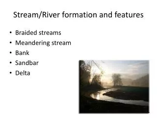
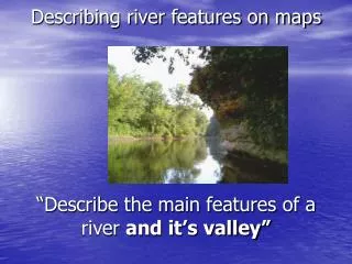
Aim- to describe and explain the formation of a variety of river features with the aid of annotated diagrams Within sections of the river channel, the flow tends to wind from side to side through a pattern of deep pools and shallower riffles. Riffles are formed by bed load deposits. A meander forms when the river channel bends, most of the water is directed to the outside of the bend. This reduces friction and increases the speed of the river at this point. The river therefore has more energy to transport through suspension, which will lead to erosion of the outside bank by corrasion. The bank will be undercut, collapse and retreat to leave a small river cliff. Meanwhile, there is less water on the inside of the bend, there is an increase in friction and a decrease in velocity. As the river loses energy, it deposits some of its load to form a slip off slope. Meander
Aim- to describe and explain the formation of a variety of river features with the aid of annotated diagrams Following on from the development of a meander….. Continued erosion (corrasion) on the outside of the bend results in the neck of the meander getting narrower until, usually at a time of flood, the river cuts across. The fastest current will now be flowing in the centre of the channel and deposition is now next to the banks. The original meander is blocked off to leave a crescent shaped Ox-Bow Lake. • Ox-Bow lake
Aim- to describe and explain the formation of a variety of river features with the aid of annotated diagrams Floodplain and levee In the lower course the river widens its valley through lateral erosion. At times of high discharge the river has considerable amounts of energy, which it uses to transport material through suspension. When the river overflows its banks, it will spread out over the surrounding area which is flat. This sudden increase in friction will reduce the velocity of the river causing it to deposit its load (silt). Each time the river floods another layer of silt is added creating as flat floodplain. The coarest material will be dropped first, and this can form a natural embankment, called a Levee next to the river. Levees can help to prevent further flooding.
Aim- to describe and explain the formation of a variety of river features with the aid of annotated diagrams river Current floodplain Height of old floodplain Rejuvenation is when the river is given a new lease of life and begins to erode to a new lower level. This can happen when the land was depressed during the last ice age rebounds, known as isostatic uplift. Isostactic uplift Isostatic uplift happens when the ice melts and the land pushes up again. land Weight of ice depresses The land like a sponge ICE Or when there is a change in sea level, i.e. sea levels fell during the ice age, creating a new base level for the river to erode down to. As the river erodes to its new base level it creates a new floodplain lower than the old one. Part of the old floodplain remains, above the new one. These terraces are often used as flood free sites for settlement and industry.
Aim- to describe and explain the formation of a variety of river features with the aid of annotated diagrams Delta Accumulation of silt deposited on the seabed at the month of the river. Because the river’s velocity is much reduced when it joins the sea, it must deposit its load. If the load is built up above sea level then mud banks form to create a delta. Estuary The mouth of a river where tidal effects can be seen. Most estuaries are funnel shaped, becoming wider towards the sea.
2004 past paper question 12 marks 12 marks
2004 answer • Main points which might be made are; • Erosion; • In the upper valley great deal of vertically erosion- due to steep gradient of streams, volume of water and velocity. Large bedload can cause considerable erosion at times of very heavy rainfall. • Middle valley-erosion mostly sideways- particularly at meanders-where the fastest flow on the outside of the bend causes erosion. • Lower valley- very little erosion- main work of river is now transportation. Broader deeper channels mean energy more evenly distributed. • Deposition • In upper valley- tends to be dominated by large stones and boulders- they can be transported at times of high discharge, but at other times are dumped in the stream. • In the middle valley- deposition of sand, silt and gravel at the inside of bends of meanders due to the slower flow and hence lower energy of the river at this point. • In the lower valley- silt deposited (this can form mudflats) as the river approaches the sea and slows down- gentler gradient, so load is deposited. • Credit can be awarded for details on the formation of a river delta.