Download
1 / 24
240 likes | 458 Vues
Caribbean Catastrophes and the Market. Laurie A. Johnson May 17, 2005. Agenda. RMS CAT Modeling in the Caribbean 2004 CAT Response and Activities to Date Evaluating the Caribbean Hurricane Model Performance Next Steps. Overview of Caribbean Risk.

E N D
Caribbean Catastrophes and the Market Laurie A. Johnson May 17, 2005
Agenda • RMS CAT Modeling in the Caribbean • 2004 CAT Response and Activities to Date • Evaluating the Caribbean Hurricane Model Performance • Next Steps Confidential
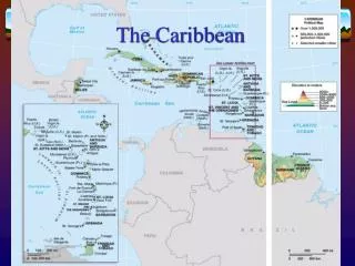
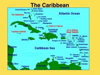
Overview of Caribbean Risk • Considerable variations in risk by peril by island across the Caribbean: • Earthquake risk dominated by proximity to the Caribbean plate boundary • An average of 9.8 named storms form annually within the Atlantic and Caribbean basins with tracks trending WNW • Considerable variation in insurance practices across the region, including availability, policy types and deductibles • Significant amount of risk is transferred outside the region through reinsurance Confidential
RMS Caribbean Models ‡ Puerto Rico * Jamaica + Entire Caribbean basin Confidential
Frances Jeanne Ivan Charley Caribbean Modeling and the 2004 Storms Confidential
Total Economic Damage in 2004 (by Country) (Source: CDERA, 2004) Confidential
RMS Activities To Date • CAT Response stochastic storm selections: • Post-landfall stochastic id’s issued based on best fit of track and central pressure • Updated stochastic id’s issued in Feb 2, with events providing better match of windspeeds at the exposure concentration: • For Grand Bahama (Freetown) and Cayman (Georgetown) extreme concentration of exposure • Modeled losses very sensitive to stochastic event windfield parameters • Bahamas and Caymans reconnaissance • Island-specific storm surge mapping • Client claims data collection initiated Confidential
Bahamas: Two Hurricanes Within 3 Weeks, September 2004 Confidential
Frances Damage on Grand Bahama • Frances crossed Grand Bahama Sept. 3 • Stalled for nearly 2 days while weakening to cat 2 with 103 mph (165 km/hr) sustained winds • 100 mph (160 km/hr) gust recorded on Grand Bahama • Major north coast storm surge • High proportion island’s total insured exposure located in Freeport (pop 27,000) (west island) • Widespread low-level roof damage • Storm surge flooding came from the north and inundated airport, commercial and residential property in northFreeport and alongthe west end Confidential
Jeanne Damage on Abaco • Jeanne’s eye crossed Abaco 3 weeks later on Sept. 25 • Cat 2 with 103 mph (165 km/hr) sustained winds strengthening to Cat 3 as it passed north • Storm surge from northeast inundated capital Marsh Harbour (pop 4,000), Treasure Cay, Cherokee Bay • North coast of outer Cays subject to wave action and erosion causing isolated building collapses • Widespread low level roof damage, particularly shingles and clay tiles Storm Surge Inundation zone Confidential
Bahamas Insights • Mandatory building code based on South Florida code • Concrete block construction on the main islands with wood frame on the outer cays • First major hurricane to directly hit Grand Bahama since 1960s/70s development of Freeport • Roof tiles cemented to roofing-felt meant that minor damage required replacement of all roof covering • On outer islands demand surge due to increased transportation and supply costs • Business interruption and contents policy uptake generally low reducing insured losses compared to economic damage Confidential
Impacted 5 islands in the southern/eastern Caribbean and 3 islands in the Northern Caribbean Resulted in 48 lives lost and multi-billion damages Southernmost cat 4/5 storm Struck Grenada directly mid-day September 7 Hurricane Ivan’s Path Across the Caribbean Confidential
Ivan’s Impact on the Cayman Islands • Ivan tracked just 21 miles (34 km) southwest of Grand Cayman, borderline category 4 5 , strongest winds directly over the capital Georgetown (pop 24,000) Confidential
1st wind Surge heights 2nd wind Ivan’s Impact on the Cayman Islands • Max sustained windspeed (airport) 149mph (240 km/hr) • Max official gust 171mph (275 km/hr); unofficial recording 190 mph (305 km/hr) on south coast • Eyewall replacement as RMax jumped from 11 to 23 miles (18 – 37 km) • Storm surge 8 – 10 feet (2.4 – 3 m) • 1st storm surge from northeast • 2nd from south as storm passed • 25% of island flooded Track Confidential
Grand Cayman Wind Damage • Caymans adopted South Florida Building Code in 1992 • Most high value buildings maintained structural integrity (but were subject to some level of roofing damage) • Building destruction restricted to older poorer quality buildings that were generally uninsured • Out of nearly 90% of properties damaged, only around 5% destroyed Confidential
Grand Cayman Storm Surge Damage • Commercial business district in Georgetown not flooded; the only high exposure area that was not flooded • Hotels concentrated along Seven Mile Beach sustainedsignificant flood damage from first surge • Only 25% hotel rooms restored by January 2005 • 10,000 cars flooded • Southeast facing coastlines suffered damaging wave action from the 2nd storm surge from the south • Many buildings demolished at South Shore Road, Bodden Town, Breakers, East End Confidential
MDR (%) Windspeed Evaluating the Caribbean Model’s Performance LOSS Define Hurricane Assess Wind speed Calculate Damage • Basin-wide stochastic tracks with realistic lifetime histories • Models clash and risk from by-passing storms • Time-stepping windfield calculations • Directional factors for surface roughness • High-resolution topography/land cover calculations • Regional code and construction variations • Detailed building inventory • Calibrated using claims and engineering studies Confidential
Stochastic Module Robustness • RMS stochastic tracks represent the actual and potential correlation of risk between different regions (Clash) CAT 1/2 storms that cross Barbados, Puerto Rico and north Bahamas CAT 2/3 storms that cross the Bahamas CAT 4/5 storms that cross Grenada and Jamaica CAT 4/5 storms that cross Grenada, Jamaica and Caymans Confidential
Hazard Module Evaluation: 100-Year Return Period Windspeeds (m/sec) 10 min winds at 10m above open water conditions; no roughness and topography factors applied. Confidential
Reconstructing Ivan’s Windfield in the Caymans Confidential
Ivan mid S coast (including waves) Storm Surge Mapping: Inundation vs. Wave Action Confidential
Storm Surge Modeling: Reconstructing Ivan’s Surge on the Caymans Confidential
Dominican Republic Storm Surge – Understanding Risk by Territory The Bahamas Population: 301,790 Total Area: 13,940 sq km Highest point: Mount Alvernia, on Cat Island, 63 m Dominican Republic Population: 8,950,034 Total Area: 48,730 sq km Highest point: Pico Duarte 3,175 m Nassau Eleuthera Andros The Bahamas Confidential
Next Steps • Detailed post-mortem on 2004 Caribbean claims and losses: • Analysis by occupancy, building type, age, materials of construction, distance to coast, BI etc. • Differentiate between flood and wind claims at high resolution • Collect high-windspeed data useful for U.S. calibration as well • Initiating the 2006 Upgrade: • Residential and commercial vulnerability calibration • Addition of storm surge modeling • Caribbean Industry Exposure Data Confidential