Download
1 / 28
280 likes | 398 Vues
UWKA and WCR. Data summaries, issues, problems, availability, etc WCR data processing : Dave Leon, Sam Haimov, Rick Damiani UWKA data processing: Glenn Gordon, Perry Wechsler, Larry Oolman Students: Qun Miao (PhD), Tim Trudel (MS). http://flights.uwyo.edu/ihop02/. date. UWKA data.

E N D
UWKA and WCR Data summaries, issues, problems, availability, etc WCR data processing : Dave Leon, Sam Haimov, Rick Damiani UWKA data processing: Glenn Gordon, Perry Wechsler, Larry Oolman Students: Qun Miao (PhD), Tim Trudel (MS) http://flights.uwyo.edu/ihop02/
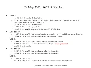
date UWKA data location WCR times UTC WCR modes* comments WCR echo strength CI Coordination with P-3 Falcon S-POL armada 5/22 all OK Homestead 21:45-23:43 VPDD (5), UD (2), P (2) Clear dryline, with deeper drier BL to the west good none + - + + Tornado radar 5/24 all OK Shamrock 18:53-21:13 VPDD (7), UD (4) 6 dryline transects (2 at low levels), 11 cold-front transects (4 at low levels) very good east of cold front, but aligned with it + + - + 6/02 Heiman dead Garden City 21:07-23:30 UP (3), P (1), nadir beam dead 2 microbursts, some hi-based precip poor none + - - - 6/03 Heiman dead Liberal 17:14-20:41 22:33-23:45 VPDD (11), UD (2) 12 legs across a weakening cold front, 1 leg along it mediocre none + - + + mips Tornado radar 6/9 all OK Guymon [17:00-19:09] all beams dead 1 long E-W low-level leg into NM, 3 UWKA soundings - none + - - + 6/10 all OK north of Dodge City [18:56-22:20] all beams dead line-normal stack, 11 legs between 160-1500 m AGL, plus 2 soundings - vigorous, within IOR + - - + 6/12 all OK east of Homestead 17:50-22:00 VPDD (15), UD (4) N-S line-normal stack, none parallel to the ‘fat-line’ good on a fine line, east of the boundary we sampled + - + + 6/15 all OK Dumas 17:39-20:57 VPDD (8), UD (4) E-W line-normal stack, none parallel of the diffuse boundary mediocre none + + (+) + 6/18 all OK Sublette 17:48-22:03 VPDD (6), UD (6) ESE-WNW line-normal stack, none parallel; followed retreating line well mediocre within IOR, but benign + - - + 6/19 all OK Goodland 17:48-22:03 VPDD (7), UD (3), UP (4), P(1) ESE-WNW line-normal stack, one excellent parallel leg good excellent CI sampled + - - +
Summary case study priorities 5/24: highest priority 6/19: high priority 6/12: priority 5/22, 6/3, 6/15, 6/18: possible use (more for intercomparison than for CI case study) Other CI data (purple in previous table): no interest
Wyoming Cloud Radar 95 GHz (3 mm) - Doppler
c c WCR through nadir port Vertical-Plane Dual-Doppler w = -Vn -winsects u = Vf - Vn - uinsects sina tana --> extract circulation (u,w) below AC a
name mode antenna PRF (kHz) pulse (ns) # rg Dr (m) Rmax (m) Flight legs (height AGL) WCR operational modes A-250-SPP SPPmag side 20 225 150 30 4500 CI – along @ ~200 m [default] A-PP4 PPmag4 side 10/15/20 225 150 30 4500 CI – along @ ~200 m [try] A-500-SPP SPPmag side 10 500 150 50 7.5 km CI – along @ ~200 m [try] ABL - @ 0.55 & 0.8 Zi [try] CI – across @ 0.6 Zi [try] low-SPP SPPmag up 20 225 150 15 2250 CI – across @ ~200 m [default] ABL – 50 m & 0.25 Zi [default] bore @ 300 m [default] X-lo-PP4 PPmag4 VPDD 20 225 100 15 1500 CI – across @ 0.6 Zi [default] ABL – @ 0.55 Zi and 0.8 Zi [try] X-hi-PP4 PPmag4 VPDD 20 (10 between bursts) 225 100 30 3000 (z) 2600 (xz) CI – across and box @ 1.5 Zi [default] ABL – @ 0.5 Zi [try] ABL – @ 1.2 Zi [default] M-PP4 PPmag4 nadir/up 20 (10 between bursts) 225 100 15 1500 up 1500 dn ABL – @ 30 m [when feeling lousy] ABL – @ 0.5 Zi [default] CI – across @ 0.6 Zi [try] Add, only if velocity folding is a problem: X-hi-PP6 PPmag6 VPDD 15 & 20 staggered 225 150 20 3000 CI – across and box @ 1.5 Zi [try] CI – across @ 0.6 Zi [try] bore @ 0.8, 1.6, 2.4 km [default]
WCR/UWKA data • Most WCR data processed at this time • netcdf • time-corrected • corrected for aircraft motion • bad data due to radio-interference corrected or omitted • UWKA probe data at 1 Hz and 25 Hz • Plans for higher level WCR reflectivity and velocities • focus on a few key CI days • probably structured 1 file = 1 flight leg • probably downgraded (eg 30 Hz to 2 Hz) • possibly merged dataset (WCR + UWKA, same time stamp) • probably not: • 2D gridded • Dual-Doppler synthesized
19:42 UTC 24 May AMA 19:52 UWKA N 19:43 cold front dryline WCR up-looking, flight level 165 m
frontal motion Total leg length: 12 km
20:10 Z VPDD cold front and dryline have collapsed Flight level: ~2300 m AGL cold front below @ 20:09 Z frontal motion SSE 164 NNW 344 front & dryline moist air cold air
Height below flight level (m) Time (UTC) WCR nadir antenna reflectivity Flight level: 2300 m AGL dBZ Aspect ratio : 2:1
Height above flight level (m) total length: 11.2 km aspect ratio: 1:1 NW 315 flight level: 360 m AGL frontal motion SE 135 19:33 - 19:35:33 possibly stratus clouds frontal motion WNW 344 ESE 164 20:21:50 - 20:25:40 front km -5 frontal motion SSE 164 NNW 344 km dBZ 6 8 -45 20:27:00 - 20:30:48 km NW 300 frontal motion SE 120 20:42:43 - 20:46:18
21:06:36-21:13:20 Gravity waves in the cold-frontal stratus frontal motion This is a cloud whose towering tops had grown well above 4 km AGL, part of a line of storm cells aligned with the cold front mixing ratio 9 km Deep convection develops 9 km ahead of sfc cold front w 21:05 21:15 wind direction 21:32 q qe WNW 290 ESE 110
19 June 20:06 UWKA 20:03 ‘dryline’ wind shift
height AGL (m) 19 June 2000 1500 1 m/s 4 m/s 1 m/s 1000 UWKA flight level (~880 m) 500 0 SE NW wind direction mixing ratio 11 km q qe mixing ratio vertical velocity
June 19 21:22 - 21:25 UTC N flight level: 1280 m MSL ( 300 m AGL) ‘dryline’ wind shift 21:18 UTC looking SE
‘dryline’ SE NW 1.5 km displacement plume on the dry side mixing ratio relative humidity buoyant plume! qe q
19 June 21:33 UWKA 21:37 Deep convection pops up on the moist side, some 10 km east of the fine line ‘dryline’ wind shift
height AGL (m) 2000 1000 UWKA flight level (~745 m) 0 Signal overwhelmed by rain drops wind direction mixing ratio NW SE 13.6 km qe q RH w 19 June
Research objectives • Understand WCR echo plumes (mainly BLH) • vertical structure (echo and velocity) • compare vertical velocities (UWKA vs WCR) • document buoyancy and moisture anomalies • interpret the BL dynamics, possibly in relation to land surface heterogeneity • CI case studies • background info (sondes, satellite, ELDORA, ground radars) • focused on WCR & UWKA data • Structure and evolution • Kinematics (updraft, VPDD) • Dynamical interpretation • priorities: May 24, June 19 (, June 12, …)
May 31 – BLH mission – 38 km total length – 1:1 aspect ratio
questions • Quiescent BL (BLH-BLE) • Are bug plumes thermals? • Do bug plumes transfer moisture/heat? • Do bugs oppose the updraft in which they are embedded? • What is the vertical velocity structure within plumes? • How do plumes evolve and/or move? • How do plumes behave spatially (spacing, width, geographic preference …)? • How does plume location relate to BL structure (shear, depth, land surface properties? • CI case studies • WCR and UWKA documented structure and evolution • Kinematics (updraft, VPDD) • Dynamical interpretation: what triggers deep convection? • priorities: May 24, June 19 (, June 12, May 22, June 3…)