Download
1 / 36
360 likes | 620 Vues
Orientation Location Scale. By: Eleanor Joyce City of Salem Schools. Objectives. Prior to this activity, the students have demonstrated a knowledge of The definition of latitude and longitude The concept of hemisphere and how the globe is divided into four hemispheres.

E N D
Orientation Location Scale By: Eleanor Joyce City of Salem Schools
Objectives • Prior to this activity, the students have demonstrated a knowledge of • The definition of latitude and longitude • The concept of hemisphere and how the globe is divided into four hemispheres. • The Student will draw a compass rose and determine orientation on a map. • The student will locate and label latitude and longitude coordinates on a map of the world • The student will state the relative location of regions on a map. • The student will estimate the distance between two points on a map by using a scale of miles. • The student will compare maps to understand how the scale ratio determines the amount of detail on a map.
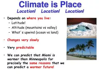
Orientation Location or position relative to the points on the compass. Cardinal Directions– North, South, East, West Intermediate Directions- Northwest, Northeast, Southeast, Southwest
Draw a compass rose and fill in the cardinal and intermediate directions.
Answers North Northwest Northeast West East Southwest Southeast South Never Eat Shredded Wheat
Location Absolute and Relative
Relative Location The description of the location of a place in relationship to another place.
Europe NorthAmerica Asia Africa SouthAmerica Australia Antarctica Europe is located North of Africa North America is located of South America Next North
Europe NorthAmerica Asia Africa SouthAmerica Australia Antarctica Asia is located of Europe. Australia is located of Antarctica. East Next Northeast
Absolute Location The global address of a point on the globe is an absolute location. The latitude and longitude coordinates define the absolute location of a point on the globe. The correct order for global addresses are North and South followed by East and West 60°N, 120°W is a correctly written address.
Absolute location is the point were lines of latitude and longitude intersect on a grid. Longitude lines or Meridians run north to south but are read east to west. Latitude lines or Parallel lines run east to west but are measured north to south.
Step 1. Highlight the Equator Step 2. Highlight the Prime Meridian. Next
NW NE SW SE Step 3. Draw and X where the two lines intersect. Step 4. Label the hemispheres Next
20°N, 80° W NW NE SW SE • Step 5. Locate 20°N, 80° W • Locate the Northwest hemisphere. Why • Locate 20° N, draw a line along this line to the Prime Meridian . • Locate 80° W, draw a line along this line to the Equator • Where the two lines intersect is 20°N, 80° W Next
Use the same skills to identify the absolute location of the red star. What is the answer? Next 40°N, 140°E.
Use the same skills to identify the absolute location of the red star. What is the answer? Next 60°S, 60°E.
Use the same skills to identify the absolute location of the red star. What is the answer? Next 20°S, 20°W.
Use the same skills to identify the absolute location of the red star. What is the answer? Next 20°N, 0°.
Use the same skills to identify the absolute location of the red star. What is the answer? 0°N, 100°W.
Scale Ratio between a distance on a map and the corresponding distance on the earth http://geography.uoregon.edu/buckley/teaching/geog311/lectures/lecture4%20-%20map%20scale/sld003.htm
Representative Fraction • a fraction or ratio between units on themap and units on the earth’s surface • format • 1:1,000,000 OR 1/1,000,000 http://geography.uoregon.edu/buckley/teaching/geog311/lectures/lecture4%20-%20map%20scale/sld003.htm
Graphic or Bar Scale • a line subdivided like a ruler to show the lengths of earth distance units on the map. 0 50 100 150 200 250 300 350 1 inch = 50 miles http://geography.uoregon.edu/buckley/teaching/geog311/lectures/lecture4%20-%20map%20scale/sld003.htm
The distance from Captain Cook to Hilo would be approximately how many miles? • 10 miles • 25 miles • 50 miles • 100 miles
The distance from Captain Cook to Hilo would be approximately how many miles? • 10 miles • 25 miles • 50 miles • 100 miles
Map Scale The smaller the scale of miles, the more detail the map shows. The larger the scale of miles, the less detail the map shows.
Scale of Miles range is 0-5 miles How much detail can you see on this map?
Scale of Miles range is 0-1.2 miles How much detail can you see on this map?
Scale of Miles range is 0-.6 miles How much detail can you see on this map?
Scale of Miles range is 0-.3 miles How much detail can you see on this map?
Scale of Miles range is 0-160 yards How much detail can you see on this map?
Which map shows the most detail? A C D B
Which map shows the most detail? A C D B
Review Fill in the blanks: The larger the scale of miles, the _______ detail will be shown on the map. The smaller the scale of miles, the_______detail will be shown on the detail.
Review Fill in the blanks: The larger the scale of miles, the _______ detail will be shown on the map. The smaller the scale of miles, the_______detail will be shown on the detail. less more