Download
1 / 16
170 likes | 345 Vues
Hazard Risk and Vulnerability Analysis Sunshine Coast Regional District. PURPOSE & INTENT. Hazard identification and gap analysis. HRVA as a key component of an emergency plan. Tool to help orient resource allocation, land use planning alternatives, support future funding applications.

E N D
Hazard Risk and Vulnerability AnalysisSunshine Coast Regional District
PURPOSE & INTENT Hazard identification and gap analysis. HRVA as a key component of an emergency plan. Tool to help orient resource allocation, land use planning alternatives, support future funding applications.
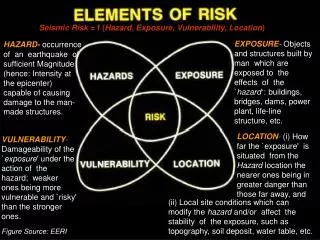
KEY TERMS HAZARD – a source of potential harm, or a situation with a potential for causing harm in terms of human injury, damage to health, property, the environment, and/or other things of value. – the chance of injury or loss as defined as a measure of the probability [likelihood] and severity or an adverse effect to health, property, the environment, or other things of value. – people, property, infrastructure, industry and resources, or environments that are particularly exposed to adverse impact from a hazard event. RISK VULNERABILITY
METHODOLOGY QUANTITATIVE & QUALITATIVE RESEARCH Survey Data Historical Data – climate, patterns & behaviours of past hazards Secondary Research – existing documents & publications Previous Assessments (general and hazard-specific) – OCPs, MoF Observation
Severity APPENDIX A – Risk Matrix Frequency Mod. Low High Very High 6 Very Likely 5 Moderate/Likely 4 Occasional/Slight Chance 3 Unlikely/Improbable 2 Highly Unlikely/Rare 1 Rare 8 16 24 32
APPENDIX E – OCP Spreadsheets Halfmoon Bay: 4,666 ha.
RESULTS STRUCTURAL FIRE / URBAN FIRE High potential for injury, fatality High potential for damage to critical infrastructure & property Adjacency – potential to damage lifelines (marinas, ferry terminal, etc) High frequency
WILD FIRE/INTERFACE FIRE 2003 : 71 fires within SCRD boundaries • 10.3 ha. • 54 lighting (76%) • 17 human carelessness(MoF, 2005) Most areas in SCRD moderate risk Extreme: Gambier & Keats Island, Sakinaw Lk. High: Halfmoon Bay, Pender Harbour (Garden Bay – Pender Hill), Roberts Creek North, Williams Landing Currently no updated fire hazard mapping (last done in 1999) Limited fire suppression capabilities, water coverage in peripheral areas, fuel loading, access for emergency vehicles
SEISMIC Coastal BC & lower mainland very active – high frequency Impact critical infrastructure Significant potential for property damage, injury, fatality Overall high risk – mitigation is difficult *For Vancouver. Onur & Seeman, 2004.
HAZMAT DG SPILL ‘in situ’– HSLP: Port Mellon, Granthams Landing, Williams Landing, Gibsons at higher risk than Roberts Creek. DG SPILL ‘in situ’ – Local: Ammonia, Propane, Diesel, etc. DG SPILL– Transport Routes: (waterways, highways) Response capability limited to containment & evacuation - SCRD and member municipalities rely on external agencies. Environmental impact, economic impact, health implications, are high.
LANDSLIDE / SUBSIDENCE January 2005 – heavy rains and soil saturation force evacuation of one household in Gibsons January 2005 – two homes in Halfmoon Bay affected by land subsidence (slumping) Extensive gravel mining and resource extraction in various areas of SCRD (Appendices E), prevalence of soft soils.
DEBRIS FLOW / RAIN STORMS Chapman Creek - early 1980s: serious flood along Chapman Creek alluvial fan results from high creek flows, high tides, storm wave action. Charman Creek -subject to high flood and debris flood hazards (1:25 – 1:100 annual). Clough Creek - November 1983: destructive debris flow runs beneath Orange Rd. and causes severe property damage.
SUBMARINE SLIDE (local marine tsunami) Anderson, P. & Gow, G. PSEPC. (2004). Rabinovich et. al., Canadian Hydrographic Service. (2003). Infrequent and difficult to detect Most commonly triggered by non-seismic events (abnormally low tides, coastal construction, heavy rainfall, strong winds, atmospheric pressure changes, sudden soil deposition) Slippage of a 1,250,000 m³ sediment lobe (the smaller of two) on Eastern shore of Texada Island would likely cause approx. 2m waves. Potentially impact Irvines Landing, Pope Landing, Donnelly Bay, Garden Bay, Madeira Park
SUBMARINE SLIDE (local marine tsunami) Low probability – close proximity (lead wave transiting Malaspina Strait and arriving at Cape Cockburn in 132 sec.) Emergent field in geophysical and disaster research – study not intended to be used as hazard assessment tool. Situational awareness & proactive planning – wise to consider potential impact of submarine slide activityon SCRD & member municipalities.