Download
1 / 16
160 likes | 251 Vues
Improving global agricultural cropland though integration and expert elicitation. Steffen Fritz Linda See Christoph Perger. Activities of IIASA in the wider field of Early warning. Global/regional land use models – impact of certain policies on GHG emissions, impact on food prices

E N D
Improving global agricultural cropland though integration and expert elicitation Steffen Fritz Linda See Christoph Perger
Activities of IIASA in the wider field of Early warning • Global/regional land use models – impact of certain policies on GHG emissions, impact on food prices • Crop modeling using crop modelling (e.g. Epic model), comparison of ASCAT Soil Moisture with EPIC soil moisture • Evaluatingthe potential of mobile phones in cropland mapping and Early Warning applications
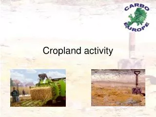
Current State of maps and possible improvements in data collection • Global Land Cover and cropland maps in particular disagree • Lots of national maps have been produced which can be integrated (e.g. Africover) • Google earth offers enormous potential to cross check and validate maps • Mobile phones allow to collect data – e.g. pictures on the ground
Geo-wiki.org www.geo-wiki.org
One Key Action from the Workshop • IIASA leads new subtask under the GEO Agriculture task, and work with the GEO Agriculture ‘Community of Practice’, Subtask: ‘Global land-use map’ • Cropland irrigated/non-irrigated • Rangelands • Crop Type • First step: Create a hybrid map of current cropland distribution.
How to make a ‘hybrid product’ • Data integration • Kind of ensemble for cropland maps • Use national and sub-national statistics • Use experts via feedback on current maps to improve at certain locations • Integrate validation points collected from very high resolution (e.g. geo-wiki) and ground points/ pictures from mobile phones
Fritz et al., 2011, A new calibrated cropland dataset for sub-saharan Africa, JGR
Invitation to our Geo-wiki training session on:Improving African cropland using integration and expert elicitationThursday afternoon 14.00-17.00Prize: co-authorship